Home > Europe > United Kingdom > England > Norfolk > North Green
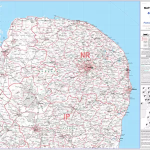
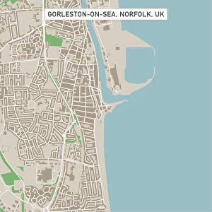
Great Yarmouth Norfolk UK City Street Map

![]()
Wall Art and Photo Gifts from Fine Art Storehouse
Great Yarmouth Norfolk UK City Street Map
Vector Illustration of a City Street Map of Great Yarmouth, Norfolk, UK. Included files are EPS (v10) and Hi-Res JPG.
Data courtesy from Ordnance Survey: VectorMap District
https:/ordnancesurvey.co.uk/business-and-government/products/vectormap-district.html
OS OpenData is free to use under the Open Government Licence (OGL).
Contains OS data eCrown copyright and database right 2017.
http:/nationalarchives.gov.uk/doc/open-government-licence/version/3/
Unleash your creativity and transform your space into a visual masterpiece!
Frank Ramspott
Media ID 15055281
© Frank Ramspott, all rights reserved
Aerial View Computer Graphic Directly Above Gray Green Norfolk North Sea Road Map Street Map Text Digitally Generated Image Great Yarmouth River Yare
FEATURES IN THESE COLLECTIONS
> Aerial Photography
> Related Images
> Arts
> Contemporary art
> Digital artwork
> Street art
> Arts
> Landscape paintings
> Waterfall and river artworks
> River artworks
> Arts
> Portraits
> Pop art gallery
> Street art portraits
> Arts
> Street art graffiti
> Digital art
> Digital paintings
> Arts
> Street art graffiti
> Digital art
> Vector illustrations
> Europe
> United Kingdom
> England
> Norfolk
> Great Yarmouth
> Europe
> United Kingdom
> England
> Norfolk
> North Green
> Europe
> United Kingdom
> England
> Norfolk
> Related Images
> Europe
> United Kingdom
> Maps
> Fine Art Storehouse
> Map
> Street Maps
EDITORS COMMENTS
This print showcases a meticulously detailed city street map of Great Yarmouth, Norfolk, UK. The vector illustration captures the essence of this charming coastal town, highlighting its key features such as the meandering River Yare and the picturesque coastline along the North Sea. The image is digitally generated with precision and creativity, presenting an aerial view directly above the city streets. The design incorporates various colors including shades of gray, green, blue, and white to bring out different elements on the map. With no people in sight, it allows viewers to focus solely on exploring the intricate cartography presented before them. Every road and building is intricately depicted in this visually stunning artwork. Data courtesy from Ordnance Survey's VectorMap District ensures accuracy and reliability in representing Great Yarmouth's geography. This high-resolution print comes with EPS (v10) and Hi-Res JPG files for versatile usage options. As an added bonus, this artwork falls under OS OpenData which means it can be freely used under the Open Government Licence (OGL). It is a testament to Frank Ramspott's talent as he masterfully combines technology with artistry to create a captivating representation of Great Yarmouth that will surely captivate any viewer’s imagination.
MADE IN THE USA
Safe Shipping with 30 Day Money Back Guarantee
FREE PERSONALISATION*
We are proud to offer a range of customisation features including Personalised Captions, Color Filters and Picture Zoom Tools
SECURE PAYMENTS
We happily accept a wide range of payment options so you can pay for the things you need in the way that is most convenient for you
* Options may vary by product and licensing agreement. Zoomed Pictures can be adjusted in the Cart.