Home > Arts > Street art graffiti > Digital art > Vector illustrations
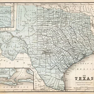
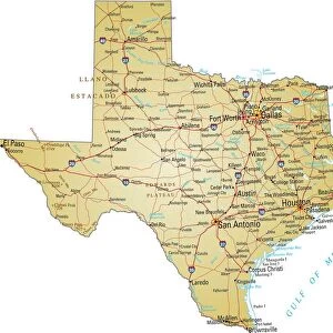
Mesquite Texas US City Street Map

![]()
Wall Art and Photo Gifts from Fine Art Storehouse
Mesquite Texas US City Street Map
Vector Illustration of a City Street Map of Mesquite, Texas, USA. Scale 1:60, 000.
All source data is in the public domain.
U.S. Geological Survey, US Topo
Used Layers:
USGS The National Map: National Hydrography Dataset (NHD)
USGS The National Map: National Transportation Dataset (NTD)
Unleash your creativity and transform your space into a visual masterpiece!
Frank Ramspott
Media ID 15192944
© Frank Ramspott, all rights reserved
Aerial View City Map Computer Graphic Directly Above Downtown District Gray Mesquite Road Map Texas Text Digitally Generated Image Green Color White Color
FEATURES IN THESE COLLECTIONS
> Aerial Photography
> Related Images
> Animals
> Insects
> Hemiptera
> Green Scale
> Arts
> Contemporary art
> Digital artwork
> Street art
> Arts
> Landscape paintings
> Waterfall and river artworks
> River artworks
> Arts
> Portraits
> Pop art gallery
> Street art portraits
> Arts
> Street art graffiti
> Digital art
> Digital paintings
> Arts
> Street art graffiti
> Digital art
> Vector illustrations
> Fine Art Storehouse
> Map
> Street Maps
> Fine Art Storehouse
> Map
> USA Maps
> Maps and Charts
> Geological Map
> Maps and Charts
> Related Images
> North America
> United States of America
> Lakes
> Related Images
EDITORS COMMENTS
This print showcases a meticulously crafted vector illustration of the vibrant city street map of Mesquite, Texas, USA. With a scale of 1:60,000, every intricate detail is brought to life in this visually stunning artwork. The source data used for this creation is all from the public domain and includes USGS The National Map's National Hydrography Dataset (NHD) and National Transportation Dataset (NTD). The mesmerizing design encompasses various elements that define Mesquite's charm. From its bustling downtown district to the serene lake and river that grace its landscape, this artwork beautifully captures the essence of the city. Every street and road is intricately depicted, allowing viewers to navigate through Mesquite with their eyes. Created digitally by Frank Ramspott, this image showcases his exceptional talent in cartography and design. Without any human presence captured in the frame, attention is solely drawn towards the rich colors that dominate the composition – gray streets intertwined with blue rivers against a backdrop of white buildings surrounded by lush greenery. With an aerial view directly above Mesquite's urban sprawl, this print serves as both an informative tool and a work of art. It encapsulates not only physical geography but also computer graphics expertise in bringing such detailed maps to life. Whether displayed for decorative purposes or utilized as a navigational aid, this masterpiece offers endless fascination for admirers seeking to explore every corner of Mesquite's dynamic cityscape.
MADE IN THE USA
Safe Shipping with 30 Day Money Back Guarantee
FREE PERSONALISATION*
We are proud to offer a range of customisation features including Personalised Captions, Color Filters and Picture Zoom Tools
SECURE PAYMENTS
We happily accept a wide range of payment options so you can pay for the things you need in the way that is most convenient for you
* Options may vary by product and licensing agreement. Zoomed Pictures can be adjusted in the Cart.