Home > Arts > Landscape paintings > Waterfall and river artworks > River artworks
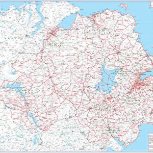
Northern Ireland Vector Road Map

![]()
Wall Art and Photo Gifts from Fine Art Storehouse
Northern Ireland Vector Road Map
Detailed vector map of Northern Ireland, including main cities, roads, rivers and lakes.
Source data courtesy of the former United States National Imagery and Mapping Agency NIMA (database: VMAP0: coastline, rivers, roads, built-up-areas), the National Geospatial-Intelligence Agency NGA (database: Geographic Names) and the Humanitarian Information Unit HIU, U.S. Department of State (database: LSIB: boundaries)
Unleash your creativity and transform your space into a visual masterpiece!
Frank Ramspott
Media ID 24122347
© Frank Ramspott, all rights reserved
Belfast Circle Clip Art Computer Graphic Country Geographic Area Geography Gray Latitude Longitude Northern Ireland Road Map Square Text Vector Digitally Generated Image Londonderry
FEATURES IN THESE COLLECTIONS
> Arts
> Landscape paintings
> Waterfall and river artworks
> River artworks
> Arts
> Photorealistic artworks
> Detailed art pieces
> Masterful detailing in art
> Arts
> Street art graffiti
> Digital art
> Digital paintings
> Arts
> Street art graffiti
> Digital art
> Vector illustrations
> Europe
> Related Images
> Europe
> Republic of Ireland
> Lakes
> Related Images
> Europe
> Republic of Ireland
> Maps
> Europe
> Republic of Ireland
> Paintings
> Europe
> United Kingdom
> Maps
> Europe
> United Kingdom
> Northern Ireland
> Belfast
> Fine Art Storehouse
> Travel Imagery
> Travel Destinations
> Ireland
> Londonderry, Northern Ireland
EDITORS COMMENTS
This vibrant and detailed print captures the essence of Northern Ireland in a single frame. The Northern Ireland Vector Road Map showcases the region's main cities, roads, rivers, and lakes with utmost precision. Thanks to the collaboration between various esteemed organizations such as the former United States National Imagery and Mapping Agency NIMA, the National Geospatial-Intelligence Agency NGA, and the Humanitarian Information Unit HIU of U. S. Department of State, this map is a reliable source for geographical information. The digital design of this artwork brings together elements like cartography, illustration, painting, and computer graphics seamlessly. The color image features shades of gray along with striking pops of red and black that add visual interest to every corner. With its square shape adorned by circles denoting cities and text providing additional details about latitude and longitude coordinates, this map exudes both functionality and aesthetics. Whether you are an avid traveler or simply fascinated by geography, this piece will transport you to Northern Ireland's enchanting landscapes from afar. From bustling Belfast to historic Londonderry (also known as Derry), every significant location is beautifully represented on this map print by Frank Ramspott.
MADE IN THE USA
Safe Shipping with 30 Day Money Back Guarantee
FREE PERSONALISATION*
We are proud to offer a range of customisation features including Personalised Captions, Color Filters and Picture Zoom Tools
SECURE PAYMENTS
We happily accept a wide range of payment options so you can pay for the things you need in the way that is most convenient for you
* Options may vary by product and licensing agreement. Zoomed Pictures can be adjusted in the Cart.