
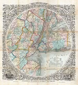
1853 Collection (#4)

In the year 1853, a tapestry of historical events unfolded, leaving an indelible mark on various aspects of society

Background image1853 Collection: 1853 Mitchell Map Of Austria Topography Cartography

1853 Mitchell Map Of Austria Topography Cartography
1853, Mitchell Map of Austria

Background image1853 Collection: 1853 Mitchell Map Of Asia Topography Cartography

1853 Mitchell Map Of Asia Topography Cartography
1853, Mitchell Map of Asia

Background image1853 Collection: 1853 Mitchell Map Of China Topography Cartography

1853 Mitchell Map Of China Topography Cartography
1853, Mitchell Map of China

Background image1853 Collection: 1853 Mitchell Map Of Arkansas Topography Cartography

1853 Mitchell Map Of Arkansas Topography Cartography
1853, Mitchell Map of Arkansas

Background image1853 Collection: 1853 Mitchell Map Of Germany Topography Cartography

1853 Mitchell Map Of Germany Topography Cartography
1853, Mitchell Map of Germany

Background image1853 Collection: 1853 Mitchell Map Of France Topography Cartography

1853 Mitchell Map Of France Topography Cartography
1853, Mitchell Map of France

Background image1853 Collection: 1853 Mitchell Map Of Greece Topography Cartography

1853 Mitchell Map Of Greece Topography Cartography
1853, Mitchell Map of Greece

Background image1853 Collection: 1853 Mitchell Map Of Louisiana Topography Cartography

1853 Mitchell Map Of Louisiana Topography Cartography
1853, Mitchell Map of Louisiana

Background image1853 Collection: 1853 Kaei 6 Japanese Map Of The World Topography

1853 Kaei 6 Japanese Map Of The World Topography
1853, Kaei 6 Japanese Map of the World

Background image1853 Collection: 1853 Andrews Map Of The Great Lakes And St. Lawrence Basin

1853 Andrews Map Of The Great Lakes And St. Lawrence Basin
1853, Andrews Map of the Great Lakes and St. Lawrence Basin

Background image1853 Collection: 1853 Land Office Plat Map Of Florida Topography

1853 Land Office Plat Map Of Florida Topography
1853, Land Office Plat Map of Florida

Background image1853 Collection: 1853 U.S.C.S. Map Of Sabine Pass Texas And Louisiana

1853 U.S.C.S. Map Of Sabine Pass Texas And Louisiana
1853, U.S.C.S. Map of Sabine Pass, Texas and Louisiana

Background image1853 Collection: 1853 U.S.C.S. Map Of San Diego Bay And Los Coronados

1853 U.S.C.S. Map Of San Diego Bay And Los Coronados
1853, U.S.C.S. Map of San Diego Bay and Los Coronados

Background image1853 Collection: 1853 U.S.C.S. Map Or Chart Of Northwestern Washington State

1853 U.S.C.S. Map Or Chart Of Northwestern Washington State
1853, U.S.C.S. Map or Chart of Northwestern Washington State, Vancouver Island

Background image1853 Collection: 1853 U.S.C.S. Map Of San Francisco California And Vicinity

1853 U.S.C.S. Map Of San Francisco California And Vicinity
1853, U.S.C.S. Map of San Francisco, California and Vicinity

Background image1853 Collection: 1853 U.S.C.S. Map Of Minots Ledge Near Boston Harbor

1853 U.S.C.S. Map Of Minots Ledge Near Boston Harbor
1853, U.S.C.S. Map of Minots Ledge, near Boston Harbor, Cohasset

Background image1853 Collection: 1853 U.S.C.S. Map Of The Virginia Coast Gargathy To Machipongo

1853 U.S.C.S. Map Of The Virginia Coast Gargathy To Machipongo
1853, U.S.C.S. Map of the Virginia Coast, Gargathy to Machipongo

Background image1853 Collection: 1853 U.S.C.S. Map Of Horn Island Pass Mississippi And Louisiana

1853 U.S.C.S. Map Of Horn Island Pass Mississippi And Louisiana
1853, U.S.C.S. Map of Horn Island Pass, Mississippi and Louisiana

Background image1853 Collection: 1853 U.S.C.S. Map Of The North Edisto River South Carolina

1853 U.S.C.S. Map Of The North Edisto River South Carolina
1853, U.S.C.S. Map of the North Edisto River, South Carolina

Background image1853 Collection: 1853 U.S.C.S. Map Of St. John's River Florida

1853 U.S.C.S. Map Of St. John's River Florida
1853, U.S.C.S. Map of St. John's River, Florida

Background image1853 Collection: 1853 U.S.C.S. Map Of Timbalier Bay Louisiana

1853 U.S.C.S. Map Of Timbalier Bay Louisiana
1853, U.S.C.S. Map of Timbalier Bay, Louisiana

Background image1853 Collection: 1853 U.S.C.S. Map Of Shoalwater Bay Washington

1853 U.S.C.S. Map Of Shoalwater Bay Washington
1853, U.S.C.S. Map of Shoalwater Bay, Washington

Background image1853 Collection: 1853 U.S.C.S. Map Of Minots Ledge Near Boston Harbor

1853 U.S.C.S. Map Of Minots Ledge Near Boston Harbor
1853, U.S.C.S. Map of Minots Ledge, near Boston Harbor, Cohasset

Background image1853 Collection: 1853 U.S.C.S. Chart Or Map Of Cape Flattery And Nee-AH Harbor

1853 U.S.C.S. Chart Or Map Of Cape Flattery And Nee-AH Harbor
1853, U.S.C.S. Chart or Map of Cape Flattery and Nee-AH Harbor, Washington

Background image1853 Collection: 1853 U.S. Coast Survey Map Of Key Biscayne Bay

1853 U.S. Coast Survey Map Of Key Biscayne Bay
1853, U.S. Coast Survey Map of Key Biscayne Bay, Key West and the Cedar Keys, Florida

Background image1853 Collection: 1853 U.S. Coast Survey Nautical Chart Or Map Of Nantucket

1853 U.S. Coast Survey Nautical Chart Or Map Of Nantucket
1853, U.S. Coast Survey Nautical Chart or Map of Nantucket, Massachusetts

Background image1853 Collection: 1853 U.S. Coast Survey Map Or Chart Of Sow And Pigs Reef Off Marthas Vineyard

1853 U.S. Coast Survey Map Or Chart Of Sow And Pigs Reef Off Marthas Vineyard
1853, U.S. Coast Survey Map or Chart of Sow and Pigs Reef off Marthas Vineyard, Massachussetts

Background image1853 Collection: 1853 U.S. Coast Survey Map Of San Francisco Bay

1853 U.S. Coast Survey Map Of San Francisco Bay
1853, U.S. Coast Survey Map of San Francisco Bay, California

Background image1853 Collection: 1853 U.S. Coast Survey Map Of Ship Island Shoal

1853 U.S. Coast Survey Map Of Ship Island Shoal
1853, U.S. Coast Survey Map of Ship Island Shoal, Louisiana

Background image1853 Collection: 1853 U.S. Coast Survey Map Of Cape Fear North Carolina

1853 U.S. Coast Survey Map Of Cape Fear North Carolina
1853, U.S. Coast Survey Map of Cape Fear, North Carolina

Background image1853 Collection: 1853 U.S. Coast Survey Chart Or Map Of St. Georges Sound

1853 U.S. Coast Survey Chart Or Map Of St. Georges Sound
1853, U.S. Coast Survey Chart or Map of St. Georges Sound, Florida

Background image1853 Collection: 1853 Mitchell Map Of Argentina La Plata Uruguay And Chili

1853 Mitchell Map Of Argentina La Plata Uruguay And Chili
1853, Mitchell Map of Argentina, La Plata, Uruguay and Chili

Background image1853 Collection: 1853 Colton Map Of New York And Vicinity 33 Miles Around

1853 Colton Map Of New York And Vicinity 33 Miles Around
1853, Colton Map of New York and Vicinity, 33 Miles Around

Background image1853 Collection: 1853 Mitchell Map Of Turkey In Europe And Greece

1853 Mitchell Map Of Turkey In Europe And Greece
1853, Mitchell Map of Turkey in Europe and Greece, Greece, Balkans, Macedonia

Background image1853 Collection: 1853 Andrews Map Of The Maritime Provinces New Brunswick

1853 Andrews Map Of The Maritime Provinces New Brunswick
1853, Andrews Map of the Maritime Provinces, New Brunswick, Nova Scotia, Newfoundland

Background image1853 Collection: 1853 Mitchell Map Of Turkey In Asia Palestine

1853 Mitchell Map Of Turkey In Asia Palestine
1853, Mitchell Map of Turkey in Asia, Palestine, Syria, Iraq, Turkey

Background image1853 Collection: 1853 Mitchell Map Of Palestine Israel And The Holy Land

1853 Mitchell Map Of Palestine Israel And The Holy Land
1853, Mitchell Map of Palestine, Israel and the Holy Land

Background image1853 Collection: 1853 U.S.C.S. Map Of Galveston City And Harbor

1853 U.S.C.S. Map Of Galveston City And Harbor
1853, U.S.C.S. Map of Galveston City and Harbor, Texas

Background image1853 Collection: 1853 U.S.C.S. Coast Chart Or Map Of San Luis Pass

1853 U.S.C.S. Coast Chart Or Map Of San Luis Pass
1853, U.S.C.S. Coast Chart or Map of San Luis Pass, Texas

Background image1853 Collection: 1853 U.S.C.S. Map Of Cape Fear North Carolina

1853 U.S.C.S. Map Of Cape Fear North Carolina
1853, U.S.C.S. Map of Cape Fear, North Carolina

Background image1853 Collection: 1853 U.S.C.S. Map Of Cape Charles And Vicinity

1853 U.S.C.S. Map Of Cape Charles And Vicinity
1853, U.S.C.S. Map of Cape Charles and Vicinity, Virginia

Background image1853 Collection: 1853 U.S. Coast Survey Map Or Chart Of Bartaria Bay

1853 U.S. Coast Survey Map Or Chart Of Bartaria Bay
1853, U.S. Coast Survey Map or Chart of Bartaria Bay, Louisiana

Background image1853 Collection: 1853 U.S. Coast Survey Map Of The Romer And Flynn's Shoals Near Coney Island

1853 U.S. Coast Survey Map Of The Romer And Flynn's Shoals Near Coney Island
1853, U.S. Coast Survey Map of the Romer and Flynn's Shoals near Coney Island, New York

Background image1853 Collection: 1853 U.S. Coast Survey Map Of Lake Pontchartrain

1853 U.S. Coast Survey Map Of Lake Pontchartrain
1853, U.S. Coast Survey Map of Lake Pontchartrain, New Orleans, and the Mississippi Delta

Background image1853 Collection: 1853 Mitchell Map Of Southern Italy Naples Sicily

1853 Mitchell Map Of Southern Italy Naples Sicily
1853, Mitchell Map of Southern Italy, Naples, Sicily

Background image1853 Collection: 1853 Mitchell Map Of Northern Italy Tuscany Venice

1853 Mitchell Map Of Northern Italy Tuscany Venice
1853, Mitchell Map of Northern Italy, Tuscany, Venice

Background image1853 Collection: 1853 Mitchell Map Of California Oregon Washington

1853 Mitchell Map Of California Oregon Washington
1853, Mitchell Map of California, Oregon, Washington, Utah and New Mexico

Background image1853 Collection: 1853 Colton Map Of Washington And Oregon W- Montana

1853 Colton Map Of Washington And Oregon W- Montana
1853, Colton Map of Washington and Oregon, w- Montana, Idaho


For sale as Licensed Images

Choose your image, Select your licence and Download the media

In the year 1853, a tapestry of historical events unfolded, leaving an indelible mark on various aspects of society. Cecil Rhodes, a visionary and imperialist, was born in this transformative year. Little did he know that his ambitions would shape the future of Africa. Meanwhile, in Arles, France, Vincent van Gogh's iconic "The Yellow House" stood as a testament to his artistic genius. The vibrant hues captured within its walls echoed the spirit of creativity that permeated throughout the era. Sir Richard Francis Burton embarked on daring expeditions during this time. His insatiable thirst for adventure led him to discover hidden treasures and unravel mysteries across uncharted territories. Giuseppe Verdi's opera La Traviata graced stages worldwide with its enchanting melodies. The cover of its vocal score from 1853 serves as a visual reminder of Verdi's timeless contribution to classical music. Amidst the tranquil countryside of Aylesbury, Buckinghamshire stood the Stone Asylum—a sanctuary for those seeking solace from life's trials and tribulations. Its sturdy walls provided refuge for troubled souls in need. On distant shores, soldiers armed themselves with Indian Smoothbore muskets—Pattern 1858—a weapon that symbolized power and dominance during times of conflict. Across the Atlantic Ocean in Yonkers, New York, Otis Elevator Works revolutionized urban landscapes by introducing safe vertical transportation systems. Their factory along the Hudson River became synonymous with progress and innovation. The Emigrant Ship Hercules sailed off Cambelton in Scotland—an emblematic image representing hope and new beginnings for countless individuals seeking better lives abroad. Cecil Rhodes emerged as both hero and villain throughout history—his legacy forever entwined with tales of conquests and controversies alike. From Davie to Hero—the Right Honorable Cecil J. Rhodes left an indomitable imprint on African politics.