mail_outline sales@mediastorehouse.com
Missoula Montana US City Street MapVector Illustration of a City Street Map of Missoula, Montana, USA. Scale 1:60, 000. All source data is in the public domain. U.S
COMPUTER ROOM, 1999. Main control switchboard and operators desk at the Washington Water Power Clark Fork River Noxon Rapids Hydroelectric Development Powerhouse in Sanders County, Montana
USA, Montana, Clark Fork River, Stones (Large format sizes available)
USA, Montana, Lolo National Forest, Clark Fork River, Stones (Large format sizes available)
USA, Montana, Clark Fork River, Yarrow and stones
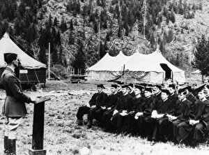
A group of Civilian Conservation Corps workers wearing caps and gowns and listening to Captain Jay Gleason give aNEW DEAL: C.C.C. 1936. A group of Civilian Conservation Corps workers wearing caps and gowns and listening to Captain Jay Gleason give a speech after receiving their high school diplomas
Hoarfrost along a slough at the Kelly Island FWP area along the Clark Fork River in Missoula, Montana
Clark Fork, MontanaClark Fork River, named for William Clark, named by Lewis and Clark expedition in Montana. Photograph
Choose your image, Select your licence and Download the media