
Colonialism Collection (page 2)

"Unveiling the Complexities of Colonialism

Background imageColonialism Collection: View over the colonial town of Olinda, UNESCO World Heritage Site, with Recife in the background

View over the colonial town of Olinda, UNESCO World Heritage Site, with Recife in the background, Pernambuco, Brazil, South America

Background imageColonialism Collection: English grandee of the East India Company riding in an Indian procession, 1825-1830

English grandee of the East India Company riding in an Indian procession, 1825-1830

Background imageColonialism Collection: In Praise of the British Empire

In Praise of the British Empire - Physical representations of the British territories of Canada, India, New Zealand, South Africa and Australia give thanks to King George V

Background imageColonialism Collection: Save Me From My Friends! Amir Sher Ali of Afghanistan endeavors to stand between the Russian bear

Save Me From My Friends! Amir Sher Ali of Afghanistan endeavors to stand between the Russian bear
SECOND AFGHAN WAR, 1878. Save Me From My Friends! Amir Sher Ali of Afghanistan endeavors to stand between the Russian bear and the British lion as each eyes the other with suspicion

Background imageColonialism Collection: Lieutenants Melvill and Coghill (24th Regiment) Dying to Save the Queens Colours, 1900

Lieutenants Melvill and Coghill (24th Regiment) Dying to Save the Queens Colours, 1900. From " South Africa and the Transvaal War, Vol. I", by Louis Creswicke. [T. C. & E. C

Background imageColonialism Collection: Major General Sir Bindon Blood, British soldier, 1902. Artist: Elliott & Fry

Major General Sir Bindon Blood, British soldier, 1902. Artist: Elliott & Fry
Bindon Blood, British soldier, 1902. Blood (1842-1940), commanding Meerut District, Bengal, was one of the few officers to see action in both the Zulu and Afghan campaigns of 1879

Background imageColonialism Collection: Captain James Cook taking possession of New South Wales in the name of the British Crown, 1770

Captain James Cook taking possession of New South Wales in the name of the British Crown, 1770. James Cook (1728-1779), English explorer, navigator and hydrographer, made three voyages of discovery

Background imageColonialism Collection: The Rhodes Colossus, 1892 Artist: Edward Linley Sambourne

The Rhodes Colossus, 1892 Artist: Edward Linley Sambourne
The Rhodes Colossus, 1892. Cecil Rhodes (1853-1902), English-born South African businessman and statesman, shown striding across Africa from Cape Town to Cairo with a telegraph wire

Background imageColonialism Collection: Swedish Church Mission, Mnene, Southern Rhodesia

Swedish Church Mission, Mnene, Southern Rhodesia (now Zimbabwe). Group of people assembled after a baptism ceremony. Date: circa 1910

Background imageColonialism Collection: Main Street, Bulawayo, Rhodesia (Zimbabwe)

Main Street, Bulawayo, Rhodesia (Zimbabwe)
Main Street, Bulawayo, Southern Rhodesia (now Zimbabwe), with the Cecil Rhodes Memorial in the distance on the left. Date: circa 1920

Background imageColonialism Collection: Kilindini Road, Mombasa, Kenya, East Africa

Kilindini Road, Mombasa, Kenya, East Africa, with Wardles Chemists, Photographers and Opticians. circa 1940

Background imageColonialism Collection: Lady Dufferin, Wife of 8th Viceroy of India

Lady Dufferin, Wife of 8th Viceroy of India
Hariot Hamilton-Temple-Blackwood, Marchioness of Dufferin and Ava (Lady Dufferin, 1843-1936), wife of Frederick Hamilton-Temple-Blackwood, 1st Marquess of Dufferin and Ava, 8th Viceroy of India

Background imageColonialism Collection: BOER WAR, 1900. Mrs. Davies, a British settler, firing on Boer positions during

BOER WAR, 1900. Mrs. Davies, a British settler, firing on Boer positions during the siege of Mafeking, South Africa, May 1900. Contemporary English drawing

Background imageColonialism Collection: Cecil Rhodes in South Africa, 1900

Cecil Rhodes in South Africa, 1900
Cecil John Rhodes, British colonial administrator, on his verandah near Cape Town, South Africa, c. 1900. Hand-colored halftone reproduction of a photograph

Background imageColonialism Collection: Map of the Americas, 1660

Map of the Americas, 1660
17th century map of the Americas. Published in Amsterdam in 1660, this map by the Dutch cartographer Frederick de Witt (1630-1706) shows the geography of the Americas

Background imageColonialism Collection: Glenelg, 1901. Creator: Unknown

Glenelg, 1901. Creator: Unknown
Glenelg, 1901. Glenelg, a suburb of Adelaide on Holdfast Bay in Gulf St Vincent, established 1836, the oldest European settlement on mainland South Australia

Background imageColonialism Collection: ANTI-RUSSIAN MAP, 1904. A Humorous Diplomatic Atlas of Europe and Asia

ANTI-RUSSIAN MAP, 1904. A Humorous Diplomatic Atlas of Europe and Asia. Japanese propaganda handbill of 1904 portraying Russia as a grasping octopus

Background imageColonialism Collection: White men bringing cleanliness to native cultures, 1890s

White men bringing cleanliness to native cultures, 1890s
" White mans burden" is to teach cleanliness, described in a Pears Soap ad, 1890s. Hand-colored halftone reproduction of a 19th-century illustration

Background imageColonialism Collection: British Viceroy of India entering Delhi, 1902

British Viceroy of India entering Delhi, 1902
Lord Curzon, British Viceroy of India, entering Delhi on an elephant, with Lady Curzon, 1902. Photograph

Background imageColonialism Collection: Poster depicting Colombo, Ceylon

Poster depicting Colombo, Ceylon
Poster for the Empire Marketing Board, depicting dock workers loading and unloading cargo at Colombo, Ceylon (Sri Lanka)

Background imageColonialism Collection: Map of the world, 1590

Map of the world, 1590
16th century map of the world. Published around 1590, this map shows the known world, including the new lands being discovered by Europeans exploring across the Atlantic

Background imageColonialism Collection: WORLD MAP / 1897

WORLD MAP / 1897
Map of the world showing British Empire possessions

Background imageColonialism Collection: Geographic map of Algeria and details of the provinces of Algiers, Oran and Constantine

Geographic map of Algeria and details of the provinces of Algiers, Oran and Constantine
XEE4405752 Geographic map of Algeria and details of the provinces of Algiers, Oran and Constantine, realized by Amboise Tardieu, 19th century

Background imageColonialism Collection: General Sir Bindon Blood, 1902

General Sir Bindon Blood, 1902. Sir Bindon Blood (1842-1940) British Army commander who served in Egypt, Afghanistan, India and Southern Africa. From " South Africa and the Transvaal War, Vol

Background imageColonialism Collection: Lord Methuen Rallying His Broken Forces at Tweebosch, 1902. Creator: Charles Mills Sheldon

Lord Methuen Rallying His Broken Forces at Tweebosch, 1902. Creator: Charles Mills Sheldon
Lord Methuen Rallying His Broken Forces at Tweebosch, 1902. Koos de la Rey ambushed Methuens column at Tweebosch on on 7 March 1902, Lord Methuen was captured by the Boers

Background imageColonialism Collection: The Night Charge of the 19th Hussars Near Lydenberg on Nov. 7th 1900, 1901. Creator

The Night Charge of the 19th Hussars Near Lydenberg on Nov. 7th 1900, 1901. Creator
The Night Charge of the 19th Hussars Near Lydenberg on Nov. 7th 1900, 1901. From " South Africa and the Transvaal War, Vol. VI", by Louis Creswicke. [T. C. & E. C. Jack, Edinburgh, 1901]

Background imageColonialism Collection: Portrait of Samuel Sewall, in periwig and long coat, c1700-1720, (1937). Creator: Unknown

Portrait of Samuel Sewall, in periwig and long coat, c1700-1720, (1937). Creator: Unknown
Portrait of Samuel Sewall, Governor and Judge of Massachusetts Colony, showing the periwig and long coat of the reign of James II, c1700-1720, (1937)

Background imageColonialism Collection: Map of Africa, 1902. Creator: Unknown

Map of Africa, 1902. Creator: Unknown
Map of Africa, 1902. Showing colonial possessions including French West Africa and German South West Africa, with insets of Table Bay in South Africa, and British and German East Africa

Background imageColonialism Collection: John Wood Approaching Bombay, c1850. Artist: Joseph Heard

John Wood Approaching Bombay, c1850. Artist: Joseph Heard
John Wood Approaching Bombay, c1850. At this time the East India Company was still governing India. The company was founded in 1600 to challenge the Dutch

Background imageColonialism Collection: General Methuen surrendering to de la Rey, 2nd Boer War, 7 March 1902

General Methuen surrendering to de la Rey, 2nd Boer War, 7 March 1902. Paul Sandford Methuen (1845-1932) British Lieutenant-General

Background imageColonialism Collection: Illustration, A Song of the English, Thames Embankment

Illustration, A Song of the English, Thames Embankment
Illustration to A Song of the English, a patriotic set of poems by Rudyard Kipling (first published in the English Illustrated Magazine)

Background imageColonialism Collection: Tanga Harbour, Tanzania

Tanga Harbour, Tanzania
Tanga Harbour, British East Africa (now Tanzania). Date: circa 1920s

Background imageColonialism Collection: Sea Scout of 1st Suva Group, Fiji, South Pacific

Sea Scout of 1st Suva Group, Fiji, South Pacific
Leslie G. Keys, Sea Scout of the 1st Suva Group, Fiji, South Pacific, with the British flag. The mat hanging behind him is to be presented to the Chief Scout

Background imageColonialism Collection: Baden Powell with Transvaal Boy Scouts Association

Baden Powell with Transvaal Boy Scouts Association
Group photo, Sir Robert Baden Powell, Chief Scout, during a visit to the Transvaal Boy Scouts Association, South Africa, 18 July 1912. Date: 1912

Background imageColonialism Collection: Rickshaw transport, Ceylon (Sri Lanka)

Rickshaw transport, Ceylon (Sri Lanka). Date: circa 1890s

Background imageColonialism Collection: Advertisment for Pears Soap, The Formula of British Conquest, Pears Soap in the Soudan

Advertisment for Pears Soap, The Formula of British Conquest, Pears Soap in the Soudan
XJF437978 Advertisment for Pears Soap, The Formula of British Conquest, Pears Soap in the Soudan, 1884 (litho) by English School

Background imageColonialism Collection: INDIA: CALCUTTA, c1786. The Old Court House and Writers Building, a home for young

INDIA: CALCUTTA, c1786. The Old Court House and Writers Building, a home for young employees of the East India Company, in Calcutta, India. Watercolor by Thomas Daniell, c1786

Background imageColonialism Collection: INDIA: CALCUTTA, 1786. Old Fort William (left), a playhouse and obelisk memorial

INDIA: CALCUTTA, 1786. Old Fort William (left), a playhouse and obelisk memorial to those who died in the Black Hole prison, in Calcutta, India. Watercolor by Thomas Daniell, 1786

Background imageColonialism Collection: SUDAN: ATBARA BATTLE, 1898. British forces, under the command of Horatio Herbert Kitchener

SUDAN: ATBARA BATTLE, 1898. British forces, under the command of Horatio Herbert Kitchener, battling the Khalifas army of dervishes at the Battle of Atbara in the Sudan, 8 April 1898

Background imageColonialism Collection: The Coronation Durbar, Delhi - George V - 1911

The Coronation Durbar, Delhi - George V - 1911
The Coronation Durbar, Delhi - 12th December 1911. The King Emperor (George V) and Queen Empress (Mary) presenting themselves to their people Date: 1911

Background imageColonialism Collection: Major General Claud Martins House, by Thomas Daniell

Major General Claud Martins House, by Thomas Daniell
Major General Claud Martins House, the Farhad Baksh, in Lucknow on the River Gumti, by Thomas Daniell (1749-1840). Date: 1789

Background imageColonialism Collection: A Pagoda in the East Indies, by Thomas Daniell

A Pagoda in the East Indies, by Thomas Daniell (1749-1840). Date: 1800

Background imageColonialism Collection: Wartime poster, The British Colonial Empire (Ceylon)

Wartime poster, The British Colonial Empire (Ceylon)
Wartime poster, The British Colonial Empire, featuring a member of the Ceylon Garrison Artillery, with the Ceylon badge below, and the names of all the colonial countries listed on either side. 1940s

Background imageColonialism Collection: Plan of the Battle of Aliwal, c1891. Creator: James Grant

Plan of the Battle of Aliwal, c1891. Creator: James Grant
Plan of the Battle of Aliwal, c1891. From " Cassells Illustrated History of India Vol. II.", by James Grant. [Cassell Petter & Galpin, London, Paris and New York]

Background imageColonialism Collection: The Negus Menelik at the battle of Adwa (colour litho)

The Negus Menelik at the battle of Adwa (colour litho)
2818920 The Negus Menelik at the battle of Adwa (colour litho) by Buffet, Paul (1864-1941); Private Collection; (add.info.: The Negus Menelik at the battle of Adwa. Painting by Paul Buffet)

Background imageColonialism Collection: Captain Cook taking possession of New South Wales, c. 1910 (colour litho)

Captain Cook taking possession of New South Wales, c. 1910 (colour litho)
IL433772 Captain Cook taking possession of New South Wales, c.1910 (colour litho) by Gilfillan, John Alexander (1793-1867) (after); Private Collection; (add.info)

Background imageColonialism Collection: Views in Bury, 1898. Creator: Unknown

Views in Bury, 1898. Creator: Unknown
Views in Bury, 1898. Bury St Edmunds, historic market town in Suffolk, supported Puritan sentiment in early 17th century and by 1640, several families had left for the Massachusetts Bay Colony

Background imageColonialism Collection: Thus Did A Hundred Men Keep Three Thousand Savages At Bay, c1908, (c1920)

Thus Did A Hundred Men Keep Three Thousand Savages At Bay, c1908, (c1920). Artist: Joseph Ratcliffe Skelton
Thus Did A Hundred Men Keep Three Thousand Savages At Bay, c1908, (c1920). In 1877, Theophilus Shepstone (1817-1893) a British South African statesman was responsible for the annexation of


For sale as Licensed Images

Choose your image, Select your licence and Download the media

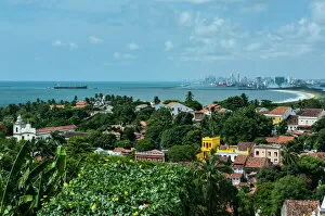
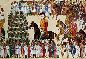
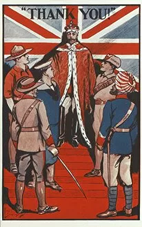
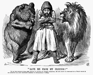
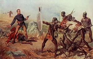
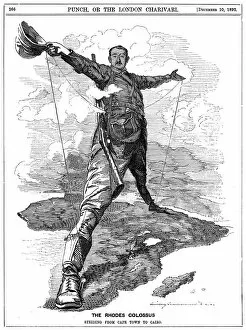
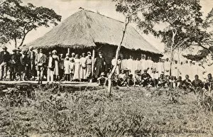
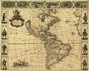
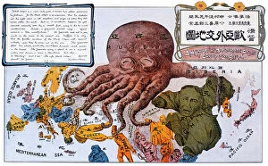
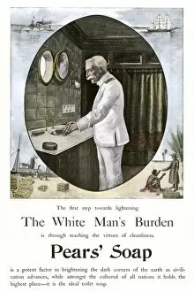
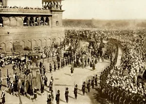
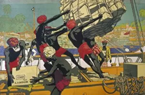
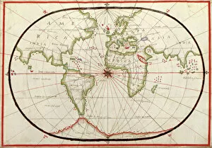
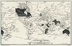
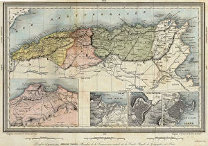
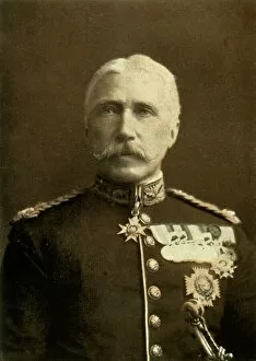
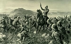
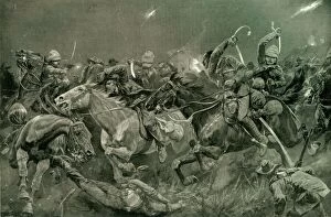
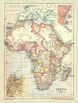
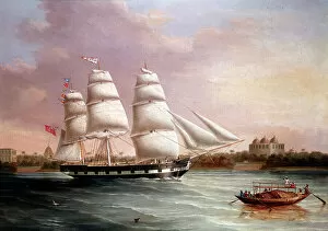
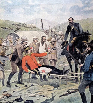
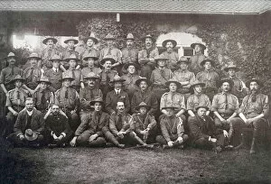
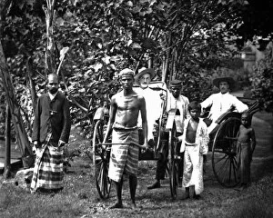
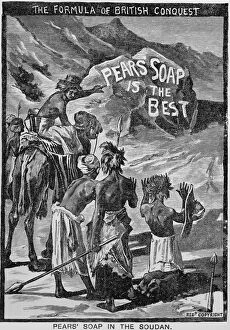
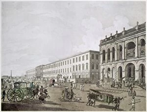
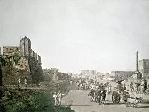
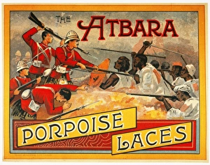
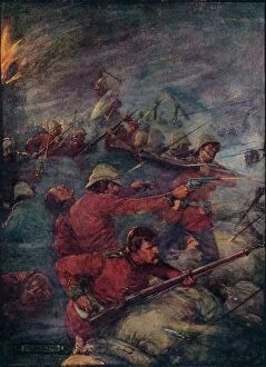
"Unveiling the Complexities of Colonialism: Tracing its Global Impact through Time and Space" Step into a captivating journey as we explore the multifaceted nature of colonialism, from its origins to its lasting effects on various regions across the world. Our first stop takes us to Kingston Norfolk Island, where restored British penal colony buildings stand as a testament to a dark chapter in history. This World Heritage listed area invites reflection on the lives impacted by this system. Next, we delve into an 1886 map of the British Empire by Walter Crane, revealing the vast extent of imperial control during that era. The empire's reach is further depicted in McVitie's World Map Empire, showcasing how Britain left an indelible mark on countless nations. As we shift our gaze towards America, we witness The Pilgrim Fathers boarding the Mayflower—a pivotal moment that laid foundations for future colonization endeavors. Meanwhile, Patersons Camp Coffee advertisement reminds us of how commerce played a significant role in sustaining these ventures. The Gordon Highlanders' heroic tale unfolds next; Piper Findlater's V. C. Win at Dargai in 1897 exemplifies both bravery and imperialism intertwined within historical narratives. A thought-provoking American cartoon from 1882 portrays England as an octopus-like figure symbolizing imperialism's insatiable appetite for land across continents. Turning our attention to Africa, an unknown creator presents us with a General Map of British South Africa from 1900—highlighting territorial divisions resulting from colonial rule. In times of war like WWI, propaganda posters such as "The Empire Needs Men" underscored how colonies were called upon to support their colonizers' interests. Venturing deeper into Africa brings us face-to-face with Congo—a powerful Punch cartoon published in 1906 that critiques European exploitation and brutality during colonization efforts. Mayo College stands tall in Ajmer, Rajasthan—an educational institution shaped by British influence, reflecting the cultural assimilation that often accompanied colonial rule.