
Country Collection (#94)

"Exploring the Essence of Country: From Golfing Legends to Artistic Masterpieces

Background imageCountry Collection: Map of the world according to Herodotus. From Cassells Universal History, published 1888

Map of the world according to Herodotus. From Cassells Universal History, published 1888

Background imageCountry Collection: Map of the kingdoms of Judah and Israel. From Cassells Universal History, published 1888

Map of the kingdoms of Judah and Israel. From Cassells Universal History, published 1888

Background imageCountry Collection: Map of Gaul in the later empire, showing the provinces and the 5th century settlements of Foedarati

Map of Gaul in the later empire, showing the provinces and the 5th century settlements of Foedarati. After an illustration by Edgar Holloway

Background imageCountry Collection: Map of northern and central Greece. From Cassells Universal History, published 1888

Map of northern and central Greece. From Cassells Universal History, published 1888

Background imageCountry Collection: Map of Macedonia and adjacent districts. From Cassells Universal History, published 1888

Map of Macedonia and adjacent districts. From Cassells Universal History, published 1888

Background imageCountry Collection: Map of ancient Egypt. From Cassells Universal History, published 1888; Illustration

Map of ancient Egypt. From Cassells Universal History, published 1888; Illustration

Background imageCountry Collection: Map of Epirus and western Greece, 295 BC. From Cassells Universal History, published 1888

Map of Epirus and western Greece, 295 BC. From Cassells Universal History, published 1888

Background imageCountry Collection: Map of Asia Minor, showing the expedition of Cyrus the Younger and retreat of the Ten Thousand

Map of Asia Minor, showing the expedition of Cyrus the Younger and retreat of the Ten Thousand. From Cassells Universal History, published 1888

Background imageCountry Collection: Map of the world according to Homer. From Cassells Universal History, published 1888

Map of the world according to Homer. From Cassells Universal History, published 1888

Background imageCountry Collection: Map of Assyria Chaldea and adjacent countries. From Cassells Universal History

Map of Assyria Chaldea and adjacent countries. From Cassells Universal History, published 1888; Illustration

Background imageCountry Collection: Ireland divided into its four province of Ulster, Munster, Connacht and Leinster

Ireland divided into its four province of Ulster, Munster, Connacht and Leinster. After a map published in 1700

Background imageCountry Collection: Map of the British Colonies south of Canada up to 1783. From British History in Periods

Map of the British Colonies south of Canada up to 1783. From British History in Periods, published 1904

Background imageCountry Collection: The Allahverdi Khan Bridge, popularly known as Si-o-se-pol, Isfahan, Iran

The Allahverdi Khan Bridge, popularly known as Si-o-se-pol, Isfahan, Iran, seen here in the 19th century, From Monuments de Tous les Peuples, published 1843

Background imageCountry Collection: The tomb of Zubaidah bint Ja far, also Zobeide or Zobaida, Baghdad, Iraq

The tomb of Zubaidah bint Ja far, also Zobeide or Zobaida, Baghdad, Iraq, seen here in the 19th century. From Monuments de Tous les Peuples, published 1843

Background imageCountry Collection: The northern gate of Hirado Castle on Firando Island, modern day Hirado Island, Japan

The northern gate of Hirado Castle on Firando Island, modern day Hirado Island, Japan, seen here in the 19th century. The northern gate

Background imageCountry Collection: The Porcelain Tower of Nanjing, part of the former Great Bao en Temple, Nanjing, China

The Porcelain Tower of Nanjing, part of the former Great Bao en Temple, Nanjing, China, seen here in the 19th century before its destruction during the Taiping Rebellion

Background imageCountry Collection: Facade of the A-Ma Temple, Macau or Macao, China, seen here in the 19th century

Facade of the A-Ma Temple, Macau or Macao, China, seen here in the 19th century. From Monuments de Tous les Peuples, published 1843

Background imageCountry Collection: Pagoda, Varanasi, aka Benares, Banaras or Kashi, Uttar Pradesh, India, seen here in the 19th century

Pagoda, Varanasi, aka Benares, Banaras or Kashi, Uttar Pradesh, India, seen here in the 19th century. From Monuments de Tous les Peuples, published 1843

Background imageCountry Collection: Map of south-Central Africa showing British and German possessions in the 1890 s

Map of south-Central Africa showing British and German possessions in the 1890 s. After a map published in the June 25th, 1890 edition of The Graphic

Background imageCountry Collection: The Tomb of Cyrus the Great, Pasargadae, Iran, seen here in the 19th century

The Tomb of Cyrus the Great, Pasargadae, Iran, seen here in the 19th century. From Monuments de Tous les Peuples, published 1843

Background imageCountry Collection: The Aqaba Castle, Mamluk Castle or Aqaba Fort, Aqaba, Jordan

The Aqaba Castle, Mamluk Castle or Aqaba Fort, Aqaba, Jordan. From Monuments de Tous les Peuples, published 1843

Background imageCountry Collection: Tomb of Absalom, aka Absaloms Pillar, Kidron Valley, Jerusalem, seen here in the 19th century

Tomb of Absalom, aka Absaloms Pillar, Kidron Valley, Jerusalem, seen here in the 19th century. From Monuments de Tous les Peuples, published 1843

Background imageCountry Collection: A View of New York in 1775. After an engraving by American artist Sidney Lawton Smith published in

A View of New York in 1775. After an engraving by American artist Sidney Lawton Smith published in 1906. As stated on the picture

Background imageCountry Collection: Interior of the citadel at Halicarnassus, Turkey. From Monuments de Tous les Peuples, published 1843

Interior of the citadel at Halicarnassus, Turkey. From Monuments de Tous les Peuples, published 1843

Background imageCountry Collection: Map of European possessions in Africa in the 1880 s. After a map which appeared in the December 20th

Map of European possessions in Africa in the 1880 s. After a map which appeared in the December 20th, 1884 edition of The Graphic

Background imageCountry Collection: Temple of Kugopea, near Tashi Lhunpo Monastery, Shigatse, Tibet, China

Temple of Kugopea, near Tashi Lhunpo Monastery, Shigatse, Tibet, China, seen here in the 19th century. From Monuments de Tous les Peuples, published 1843

Background imageCountry Collection: The Midas Monument, Gordion, Turkey, seen here in the 19th century

The Midas Monument, Gordion, Turkey, seen here in the 19th century. A Phrygian rock-cut tomb dedicated to Midas, 700 BC. From Monuments de Tous les Peuples, published 1843

Background imageCountry Collection: Canadian farmer drinking fresh milk from a metal mug from bucket; Canada

Canadian farmer drinking fresh milk from a metal mug from bucket; Canada

Background imageCountry Collection: Two young boys playing with model boats in a stream circa 1900; England

Two young boys playing with model boats in a stream circa 1900; England

Background imageCountry Collection: Ploughing the fields in 1900, horses and farmer with harvesting machine

Ploughing the fields in 1900, horses and farmer with harvesting machine

Background imageCountry Collection: Woman sitting on milking stool and milking cow by hand in 1900

Woman sitting on milking stool and milking cow by hand in 1900

Background imageCountry Collection: A new map of the British Isles, showing their ancient people, cities, and towns of note

A new map of the British Isles, showing their ancient people, cities, and towns of note, in the time of the Romans. After a map by cartographer Edward Wells published in 1800 in an atlas titled A New

Background imageCountry Collection: England and Wales in the late 18th century. After a map by cartographer and publisher William Faden

England and Wales in the late 18th century. After a map by cartographer and publisher William Faden, engraved by William Palmer

Background imageCountry Collection: An early 18th century map of the British Empire in North America also showing French

An early 18th century map of the British Empire in North America also showing French, Spanish and Dutch settlements. After a work by British cartographer Henry Popple, ? - died 1743

Background imageCountry Collection: A mid-18th century map of the British Empire in North America also showing French

A mid-18th century map of the British Empire in North America also showing French, Spanish and Dutch settlements. After a work by British cartographer Henry Popple, ? - died 1743

Background imageCountry Collection: Map of the world showing the extent of the British Empire in 1886

Map of the world showing the extent of the British Empire in 1886. The Empires territories are marked in red. The map was included as a supplement in the July 24

Background imageCountry Collection: Map of Europe under the empire of Charlemagne. From The National Encyclopaedia

Map of Europe under the empire of Charlemagne. From The National Encyclopaedia: A Dictionary of Universal Knowledge, published c.1890

Background imageCountry Collection: Map of Europe at the dismemberment of the Carolingian Empire. From The National Encyclopaedia

Map of Europe at the dismemberment of the Carolingian Empire. From The National Encyclopaedia: A Dictionary of Universal Knowledge, published c.1890

Background imageCountry Collection: The Alcazar of Segovia, Segovia, Castile and Leon, Spain, seen here circa 1838

The Alcazar of Segovia, Segovia, Castile and Leon, Spain, seen here circa 1838, before fire damaged most of its roofs. From Monuments de Tous les Peuples, published 1843

Background imageCountry Collection: The Pantheon, Rome, Italy, seen here in the 19th century. From Monuments de Tous les Peuples

The Pantheon, Rome, Italy, seen here in the 19th century. From Monuments de Tous les Peuples, published 1843

Background imageCountry Collection: Puente de Piedra (The Bridge of Stone), Lima, Peru, South America, seen here in the 19th century

Puente de Piedra (The Bridge of Stone), Lima, Peru, South America, seen here in the 19th century. From Monuments de Tous les Peuples, published 1843

Background imageCountry Collection: The walls of Tangiers, Morocco, seen here in the 19th century

The walls of Tangiers, Morocco, seen here in the 19th century. From Monuments de Tous les Peuples, published 1843

Background imageCountry Collection: The Bab al Futuh (Conquest Gate), old city of Cairo, Egypt, seen here in the 19th century

The Bab al Futuh (Conquest Gate), old city of Cairo, Egypt, seen here in the 19th century. From Monuments de Tous les Peuples, published 1843

Background imageCountry Collection: Tower of Horns, Isfahan, Iran, seen here in the 19th century

Tower of Horns, Isfahan, Iran, seen here in the 19th century. From Monuments de Tous les Peuples, published 1843

Background imageCountry Collection: A tomb near Persepolis, the ceremonial capital of the Achaemenid Empire

A tomb near Persepolis, the ceremonial capital of the Achaemenid Empire, seen here in the 19th century. From Monuments de Tous les Peuples, published 1843

Background imageCountry Collection: The Great Wall of China, seen here in the 19th century. From Monuments de Tous les Peuples

The Great Wall of China, seen here in the 19th century. From Monuments de Tous les Peuples, published 1843

Background imageCountry Collection: Temple of Borobudur, or Barabudur, Central Java, Indonesia, seen here in the 19th century

Temple of Borobudur, or Barabudur, Central Java, Indonesia, seen here in the 19th century. Built in the 9th century during the Sailendra Dynasty. From Monuments de Tous les Peuples, published 1843

Background imageCountry Collection: The Buddhas of Bamyan, Bamyan valley, Hazarajat region, central Afghanistan

The Buddhas of Bamyan, Bamyan valley, Hazarajat region, central Afghanistan, seen here in the 19th century. The statues were destroyed by the Taliban in 2001


For sale as Licensed Images

Choose your image, Select your licence and Download the media

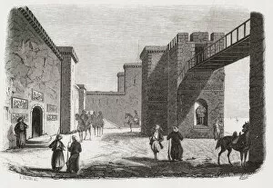
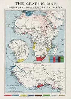
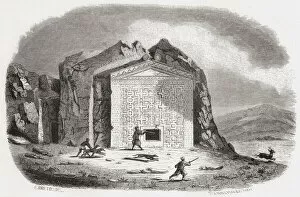
"Exploring the Essence of Country: From Golfing Legends to Artistic Masterpieces, from Celebrities to Historical Landscapes" Immerse yourself in the timeless charm life as you tee off on the iconic Swilcan Bridge, gracefully spanning across the 18th hole at St Andrews – a golfing experience like no other. Transport yourself back to 1896 with Paul Cezanne's captivating masterpiece "Le Lac d Annecy, " capturing the serene beauty of Annecy Lake. Lose yourself in this tranquil scene and let your imagination wander. Keith Urban's portrait radiates with his undeniable talent and passion for music, reminding us that country is not just about landscapes but also about soulful melodies that touch our hearts. In a world where chaos reigns, sometimes we need to embrace our inner warriors and channel our energy into a "Search And Destroy" mission against negativity – an anthem for those who dare to stand tall amidst adversity. Pieter Bruegel the Elder's enchanting painting "Hunters in the Snow" transports us back to 1565, offering a glimpse into rural life during winter. It reminds us of simpler times when nature dictated our existence. From above, witness the breathtaking beauty of British Isles illuminated by city lights under a starry sky – an awe-inspiring sight that showcases both nature's wonders and human ingenuity. Travel through time with an Anglo-Saxon map from the 10th century, tracing ancient trade routes and cultural connections that shaped Europe as we know it today. Discover how history intertwines with every corner of this diverse continent. Marvel at Earth's nocturnal tapestry as you gaze upon UK at night from space – vibrant cities glowing like constellations against darkened landscapes. A testament to humanity's resilience and creativity even after sunset falls. Delve into cartographic artistry with Orteliuss' intricate map depicting Ottoman Empire in 1570.