
Direction Collection (page 3)

Embarking on a journey through time and space, these diverse images guide us in the right direction

Background imageDirection Collection: Whale Shark (Rhincodon typus) passing by baitball, Santa Maria Island, Azores, Portugal

Whale Shark (Rhincodon typus) passing by baitball, Santa Maria Island, Azores, Portugal, September 2008 Exclusive Japanese calendar rights for 2014

Background imageDirection Collection: RF- African elephant (Loxodonta africana) at sunset. Chobe National Park, Botswana

RF- African elephant (Loxodonta africana) at sunset. Chobe National Park, Botswana. Endangered species

Background imageDirection Collection: Antique map of the Middle East with Egypt, Syria, and Israel

Antique map of the Middle East with Egypt, Syria, and Israel. Date unknown

Background imageDirection Collection: Battle of Gettysburg Map, July 3, 1863 Civil War Engraving

Battle of Gettysburg Map, July 3, 1863 Civil War Engraving
Engraving of the Map of the Battle of Gettysburgs, Pennsylvania, July 3, 1863 Civil War Engraving from Famous Leaders and Battle Scenes of the Civil War, Published in 1864

Background imageDirection Collection: Map of United States 1876

Map of United States 1876
Map of United States showing the territorial growth between 1780 and 1876

Background imageDirection Collection: Antique map of Arabian peninsula and Persia

Antique map of Arabian peninsula and Persia

Background imageDirection Collection: Antique map of Israel

Antique map of Israel

Background imageDirection Collection: Antique map of the Middle East by Halma

Antique map of the Middle East by Halma

Background imageDirection Collection: The Wine Tram, Franschhoek, Western Cape, South Africa

The Wine Tram, Franschhoek, Western Cape, South Africa

Background imageDirection Collection: Light house

Light house and sea in background, Fingal Head, Australia

Background imageDirection Collection: Head-On View Of Traffic Jam

Head-On View Of Traffic Jam
UNITED STATES - CIRCA 1940s 1950s: Head-On View Of Traffic Jam, Coming Off Ramp On Multi-Lane Highway. (Photo by H. Armstrong Roberts/Retrofile/Getty Images)

Background imageDirection Collection: Back View Of Car With Just Married Sign

Back View Of Car With Just Married Sign
UNITED STATES - Circa 1930s: Back View Of Car With Just Married Sign. (Photo by H. Armstrong Roberts/Retrofile/Getty Images)

Background imageDirection Collection: Map of America by Gerardo Mercatore, 1512-1594

Map of America by Gerardo Mercatore, 1512-1594
Cartography, 16th century. Map of America by Gerardo Mercatore (1512-1594)

Background imageDirection Collection: View at St. Rollox Looking South East; Opening of the Glasgow and Garnkirk Railway

View at St. Rollox Looking South East; Opening of the Glasgow and Garnkirk Railway
1198425 View at St. Rollox Looking South East; Opening of the Glasgow and Garnkirk Railway, 1832 (hand-coloured lithograph) by Hill

Background imageDirection Collection: Sunset on Kallur Lighthouse on Kalsoy island, Faroe Islands, Denmark, Europe

Sunset on Kallur Lighthouse on Kalsoy island, Faroe Islands, Denmark, Europe

Background imageDirection Collection: Map of city Amsterdam Netherlands from 1881

Map of city Amsterdam Netherlands from 1881 Original edition from my own archives Source : Illustriertes Konversations Lexikon 1881

Background imageDirection Collection: Adelie penguin (Pygoscelis adeliae) diving near ice flow, Antarctica. Small reproduction only

Adelie penguin (Pygoscelis adeliae) diving near ice flow, Antarctica. Small reproduction only

Background imageDirection Collection: Map of Paris 1894

Map of Paris 1894
map/plan of the city of Paris, France

Background imageDirection Collection: western europe map 1883

western europe map 1883
a map of Western europe from 1883

Background imageDirection Collection: western europe 1867

western europe 1867
a map of Western europe from 1867, overlay with grunge burnt texture paper

Background imageDirection Collection: From the North-West, Kirkstall Abbey, c1880, (1897). Artist: Alexander Francis Lydon

From the North-West, Kirkstall Abbey, c1880, (1897). Artist: Alexander Francis Lydon
From the North-West, Kirkstall Abbey, c1880, (1897). From The Ruined Abbeys of Britain by Frederick Ross. [William Mackenzie, London, 1897]

Background imageDirection Collection: Mexico map 1897

Mexico map 1897
The World-Wide Atlas of Modern Geography, Political and Physical W. & A.K. Johnston - London 1897

Background imageDirection Collection: Horse That Took The Wrong Turning- At Epsom, by H. M. B

Horse That Took The Wrong Turning- At Epsom, by H. M. B
Maverick horse galloping the opposite direction to the rest of the race. Bateman (1887-1970) was a popular artist and regularly contributed to the Sketch, the Tatler and the Bystander

Background imageDirection Collection: Map of United States 1869

Map of United States 1869
Cornells Grammars-School Geography - S.S. Cornell - New York D. Appleton and Company 1869

Background imageDirection Collection: Map of the City of Bedford, England Victorian Engraving, 1840

Map of the City of Bedford, England Victorian Engraving, 1840
Very Rare, Beautifully Illustrated Antique Engraving of Map of the City of Bedford, England Victorian Engraving, 1840. Source: Original edition from my own archives

Background imageDirection Collection: Island of Principe Historical Map by Van Noort, Circa 1598

Island of Principe Historical Map by Van Noort, Circa 1598
Very Rare, Beautifully Illustrated Antique Engraved Victorian Illustration of Historical Map of Van Noort at the Island of Principe, 1598. Copyright has expired on this artwork. Digitally restored

Background imageDirection Collection: Antique map of Van Diemen Island off Australia with vignettes

Antique map of Van Diemen Island off Australia with vignettes

Background imageDirection Collection: Antique map of holy land including Syria and Lebanon

Antique map of holy land including Syria and Lebanon

Background imageDirection Collection: Antique map of the Black Sea and surrounding lands

Antique map of the Black Sea and surrounding lands

Background imageDirection Collection: Seaman looking at sea map and holding pair of compasses

Seaman looking at sea map and holding pair of compasses

Background imageDirection Collection: Timanfaya National Park, Lanzarote, Spain

Timanfaya National Park, Lanzarote, Spain
The road from the Timanfaya National Park on Lanzarote going back towards Yaiza

Background imageDirection Collection: Chania lighthouse with the sun right behind, at sunrise, harbour, Chania, Crete, Greece

Chania lighthouse with the sun right behind, at sunrise, harbour, Chania, Crete, Greece

Background imageDirection Collection: New and Accurate Map of Ancient and Modern Rome by Jean van Ram, copperplate

New and Accurate Map of Ancient and Modern Rome by Jean van Ram, copperplate, printed in Amsterdam circa 1691-1693
Cartography. Italy, 17th century. New and accurate map of Ancient and Modern Rome by Jean van Ram, Amsterdam 1691-1693 ca. Copperplate 50 x 59 cm

Background imageDirection Collection: The Cleveland Way Footpath at Saltwick Bay near Whitby, North Yorkshire, Yorkshire, England

The Cleveland Way Footpath at Saltwick Bay near Whitby, North Yorkshire, Yorkshire, England, United Kingdom, Europe

Background imageDirection Collection: Perch Rock Lighthouse and the sands of New Brighton at twilight, New Brighton, The Wirral

Perch Rock Lighthouse and the sands of New Brighton at twilight, New Brighton, The Wirral, Merseyside, England, United Kingdom, Europe

Background imageDirection Collection: Beachy Head and the Belle Tout lighthouse at dusk, near Eastbourne, East Sussex, England

Beachy Head and the Belle Tout lighthouse at dusk, near Eastbourne, East Sussex, England, United Kingdom, Europe

Background imageDirection Collection: East View of Brighton from Kemp Town, 1835. Creator: Dean Wolstenholme

East View of Brighton from Kemp Town, 1835. Creator: Dean Wolstenholme
East View of Brighton from Kemp Town, 1835. Antique engraving by Dean Wolstenholme Junior after Thomas Henwood. From " The History, Antiquities, and Topography of the County of Sussex

Background imageDirection Collection: Doncaster Race Course, 1940

Doncaster Race Course, 1940. Doncaster is one of the oldest established centres for horse racing in Britain, with records of regular race meetings going back to the 16th Century

Background imageDirection Collection: Map of United States 1867

Map of United States 1867
Mitchells Modern Atlas - Published by E.H. Buttler & Co - Philadelphia 1867

Background imageDirection Collection: Antique map of Israel with vignettes

Antique map of Israel with vignettes

Background imageDirection Collection: Engraving of Van Noort Landing in Manila Bay, Philippines, 1600

Engraving of Van Noort Landing in Manila Bay, Philippines, 1600
Very Rare, Beautifully Illustrated Antique Engraved Victorian Illustration of Historical Engraving of Van Noort Landing in Manila Bay, Philippines, 1600. Copyright has expired on this artwork

Background imageDirection Collection: Historical Map of Dutch Navigators Island of Bali Illustration

Historical Map of Dutch Navigators Island of Bali Illustration
Very Rare, Beautifully Illustrated Antique Engraved Victorian Illustration of Historical Map of Dutch Navigators on the Island of Bali. Copyright has expired on this artwork. Digitally restored

Background imageDirection Collection: RAOEgen

RAOEgen
Antique map of RAOEgen

Background imageDirection Collection: Romania

Romania
Antique map of Romania

Background imageDirection Collection: American ethnographic map

American ethnographic map
Illutration of American ethnographic map

Background imageDirection Collection: Potteries map

Potteries map
Antique illustration of a Potteries map

Background imageDirection Collection: Tells A story

Tells A story
Mevagissey Lighthouse cornwall


For sale as Licensed Images

Choose your image, Select your licence and Download the media

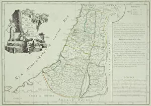
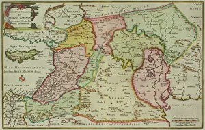
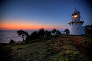
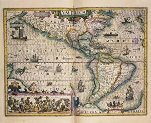
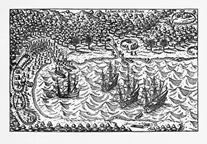
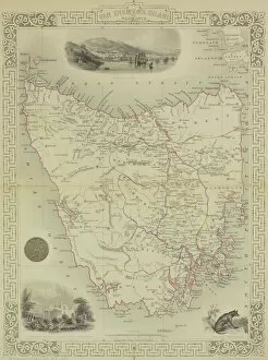
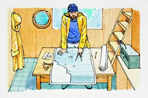
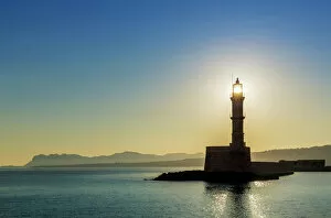
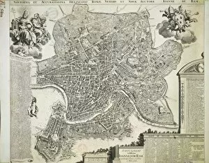
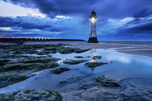
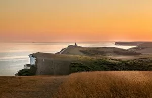
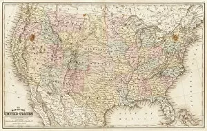
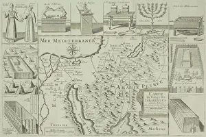
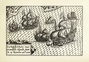
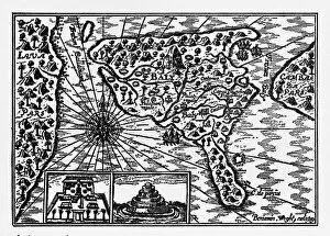
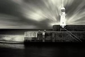
Embarking on a journey through time and space, these diverse images guide us in the right direction. From JMW Turner's iconic painting 'The Fighting Temeraire' to the ancient Mappa Mundi inked on parchment, we navigate history's vast tapestry. An antique map of Tasmania leads us to uncharted territories, while the Sturgeon Bay Lighthouse stands as a beacon of hope in Door County, Wisconsin. The rugged cliffs and lighthouse at Butt of Lewis remind us that even amidst nature's challenges, guidance is always present. In contrast, a painting showcasing Kim Jong Il and Kim Il Sung reveals an authoritarian direction taken by North Korea. Yet, it serves as a reminder that they can be shaped by ideology too. Fanad Head Lighthouse transports us to Ireland's stunning coastline where light pierces through darkness. A Viking ship silhouette against a sunset sky reminds us of our ancestors' adventurous spirit and their quest for new horizons. Meanwhile, police officers guiding children symbolize protection and nurturing guidance within our communities. Victorian engravings depict maps like the one showcasing Malvern Hills in Worcestershire; they invite exploration into England's picturesque landscapes. Griffiths Island lighthouse invites wanderers to discover its hidden beauty along Australia's coast. Lastly, National Aviation Day Display poster inspires dreams to take flight with its depiction of soaring planes against blue skies – reminding us that sometimes all we need is a little push towards our aspirations. Through artistry and imagery from various corners of the world, these captivating visuals point towards different directions – both literal and metaphorical – inviting us to embark on unique journeys filled with wonderment.