
Drone Point Of View Collection (page 5)

Experience the breathtaking beauty of the world from a drone's perspective

Background imageDrone Point Of View Collection: Car traveling on ice track on a frozen lake in the snow covered landscape, Jokkmokk, Norrbotten

Car traveling on ice track on a frozen lake in the snow covered landscape, Jokkmokk, Norrbotten, Lapland, Sweden, Scaninavia, Europe

Background imageDrone Point Of View Collection: Aerial drone 180 degree panoramic view of Falesia cliffs, Vilamoura, Algarve, Portugal, Europe

Aerial drone 180 degree panoramic view of Falesia cliffs, Vilamoura, Algarve, Portugal, Europe

Background imageDrone Point Of View Collection: Aerial drone view of Praia de Vilamoura in Vilamoura, looking west, Algarve, Portugal, Europe

Aerial drone view of Praia de Vilamoura in Vilamoura, looking west, Algarve, Portugal, Europe

Background imageDrone Point Of View Collection: Aerial drone panoramic view of Santa Marta, Santa Marta House Museum

Aerial drone panoramic view of Santa Marta, Santa Marta House Museum and Condes de Castro Guimaraes Museum next to turquoise water in Cascais, Lisbon Region, Portugal, Europe

Background imageDrone Point Of View Collection: Aerial drone panoramic view of Cascais and Estoril coastlines with turquoise water, Cascais

Aerial drone panoramic view of Cascais and Estoril coastlines with turquoise water, Cascais, 30km west of Lisbon, Portuguese Riviera, Portugal, Europe

Background imageDrone Point Of View Collection: Aerial drone panoramic view of Magdalena Peninsula, a 69-acre peninsula near the entrance to

Aerial drone panoramic view of Magdalena Peninsula, a 69-acre peninsula near the entrance to the Bay of Santander in the city of Santander, Cantabria, north coast, Spain, Europe

Background imageDrone Point Of View Collection: Aerial view of Faro De La Isla De Mouro (Faro de Mouro) across from the Magdalena Peninsula in

Aerial view of Faro De La Isla De Mouro (Faro de Mouro) across from the Magdalena Peninsula in Santander, Cantabria, Spain, Europe

Background imageDrone Point Of View Collection: Aerial panoramic view of the Magdalena Peninsula, a 69-acre peninsula near the entrance to the Bay

Aerial panoramic view of the Magdalena Peninsula, a 69-acre peninsula near the entrance to the Bay of Santander in the city of Santander, Cantabria, north coast, Spain, Europe

Background imageDrone Point Of View Collection: Archanes village with views to Mount Juktas, Crete, Greek Islands, Greece, Europe

Archanes village with views to Mount Juktas, Crete, Greek Islands, Greece, Europe

Background imageDrone Point Of View Collection: Medieval round tower standing on top of a cliff facing the sea at sunset, aerial shot, Sabaudia

Medieval round tower standing on top of a cliff facing the sea at sunset, aerial shot, Sabaudia, Circeo National Park, Latina province, Latium, Lazio, Italy, Europe

Background imageDrone Point Of View Collection: Panoramic aerial view of Ponza island lighthouse, Punta della Guardia

Panoramic aerial view of Ponza island lighthouse, Punta della Guardia, standing on top of a cliff facing the sea at dusk, Ponza island, Pontine islands, Mediterranean Sea, Latium, Lazio, Italy, Europe

Background imageDrone Point Of View Collection: Aerial view of Punta della Guardia lighthouse on top of a cliff on the island of Ponza

Aerial view of Punta della Guardia lighthouse on top of a cliff on the island of Ponza, lit from sunrise, Ponza island, Pontine islands, Mediterranean Sea, Latium, Lazio, Italy, Europe

Background imageDrone Point Of View Collection: Aerial view of the medieval castle of Vicalvi, with red cross painted on the perimetral wall

Aerial view of the medieval castle of Vicalvi, with red cross painted on the perimetral wall, overlooking the illuminated old village at dusk, Vicalvi, Frosinone province, Ciociaria, Latium region

Background imageDrone Point Of View Collection: Winter view of the snowy medieval village of Rocca Calascio with the castle on top of the hill at

Winter view of the snowy medieval village of Rocca Calascio with the castle on top of the hill at dusk, Rocca Calascio, Gran Sasso e Monti della Laga National Park, Campo Imperatore

Background imageDrone Point Of View Collection: Aerial winter view of Rocca Calascio castle and the Santa Maria della Pieta church in the snowy

Aerial winter view of Rocca Calascio castle and the Santa Maria della Pieta church in the snowy landscape at dusk, Campo Imperatore, L'Aquila province, Abruzzo region, Italy, Europe

Background imageDrone Point Of View Collection: Aerial view of the medieval castle of Vicalvi overlooking the valley with red cross painted

Aerial view of the medieval castle of Vicalvi overlooking the valley with red cross painted on the perimetral wall, at sunset, Vicalvi, Frosinone province, Ciociaria, Latium region, Lazio, Italy

Background imageDrone Point Of View Collection: Winter view of the snow covered illuminated medieval village of Rocca Calascio with the castle at

Winter view of the snow covered illuminated medieval village of Rocca Calascio with the castle at dusk, Rocca Calascio, Gran Sasso e Monti della Laga National Park, Campo Imperatore

Background imageDrone Point Of View Collection: Aerial panoramic drone view of Olhao, officially known as Olhao da Restauracao

Aerial panoramic drone view of Olhao, officially known as Olhao da Restauracao, a city and municipality in the Algarve region, southern Portugal, Europe

Background imageDrone Point Of View Collection: Aerial drone panoramic view of Bilbao, population 345000, Basque Country, northern Spain, Europe

Aerial drone panoramic view of Bilbao, population 345000, Basque Country, northern Spain, Europe

Background imageDrone Point Of View Collection: Aerial drone view of Olhao, officially known as Olhao da Restauracao

Aerial drone view of Olhao, officially known as Olhao da Restauracao, a city and municipality in the Algarve region, southern Portugal, Europe

Background imageDrone Point Of View Collection: Aerial panoramic view of Matterhorn in autumn fog at dawn, Zermatt, Valais canton, Switzerland

Aerial panoramic view of Matterhorn in autumn fog at dawn, Zermatt, Valais canton, Switzerland, Europe

Background imageDrone Point Of View Collection: Aerial view of Matterhorn mountain peak in a sea of clouds at dawn, Zermatt, canton of Valais

Aerial view of Matterhorn mountain peak in a sea of clouds at dawn, Zermatt, canton of Valais, Switzerland, Europe

Background imageDrone Point Of View Collection: Drone shot of tractor with mower mowing grasses on agricultural field during a summer day, Italy

Drone shot of tractor with mower mowing grasses on agricultural field during a summer day, Italy, Europe

Background imageDrone Point Of View Collection: Bird's eye view of two combined tractors mowing a yellow meadow in two different rows, Italy, Europe

Bird's eye view of two combined tractors mowing a yellow meadow in two different rows, Italy, Europe

Background imageDrone Point Of View Collection: Aerial drone panoramic view of promenade in Cascais, on the Portuguese Riveira 30km west of Lisbon

Aerial drone panoramic view of promenade in Cascais, on the Portuguese Riveira 30km west of Lisbon, with Estoril visible on the far right, Cascais, Portugal, Europe

Background imageDrone Point Of View Collection: Aerial drone view of Baixa District, facing south towards the Tagus River with the major landmarks

Aerial drone view of Baixa District, facing south towards the Tagus River with the major landmarks visible including St. George Castle, Pantheon, Figueira, Rossio Square, Martim Moniz Squares

Background imageDrone Point Of View Collection: Panoramic aerial of Pitcairn island, British Overseas Territory, South Pacific, Pacific

Panoramic aerial of Pitcairn island, British Overseas Territory, South Pacific, Pacific

Background imageDrone Point Of View Collection: Aerial of Pitcairn island with St. Pauls Pool, British Overseas Territory, South Pacific, Pacific

Aerial of Pitcairn island with St. Pauls Pool, British Overseas Territory, South Pacific, Pacific

Background imageDrone Point Of View Collection: Aerial of the blue lagoon, Fakarava, Tuamotu archipelago, French Polynesia, South Pacific, Pacific

Aerial of the blue lagoon, Fakarava, Tuamotu archipelago, French Polynesia, South Pacific, Pacific

Background imageDrone Point Of View Collection: Aerial of little islet filled with birds in the lagoon of Fakarava, Tuamotu archipelago

Aerial of little islet filled with birds in the lagoon of Fakarava, Tuamotu archipelago, French Polynesia, South Pacific, Pacific

Background imageDrone Point Of View Collection: Aerial of Fakarava lagoon, Tuamotu archipelago, French Polynesia, South Pacific, Pacific

Aerial of Fakarava lagoon, Tuamotu archipelago, French Polynesia, South Pacific, Pacific

Background imageDrone Point Of View Collection: Hikueru, Tuamotu archipelago, French Polynesia, South Pacific, Pacific

Hikueru, Tuamotu archipelago, French Polynesia, South Pacific, Pacific

Background imageDrone Point Of View Collection: Aerial of sundeck over the lagoon of Fakarava, Tuamotu archipelago, French Polynesia

Aerial of sundeck over the lagoon of Fakarava, Tuamotu archipelago, French Polynesia, South Pacific, Pacific

Background imageDrone Point Of View Collection: Aerial of the lagoon of Fakarava, Tuamotu archipelago, French Polynesia, South Pacific, Pacific

Aerial of the lagoon of Fakarava, Tuamotu archipelago, French Polynesia, South Pacific, Pacific

Background imageDrone Point Of View Collection: Aerial of the Ile aux Recifs, Rangiroa atoll, Tuamotus, French Polynesia, South Pacific, Pacific

Aerial of the Ile aux Recifs, Rangiroa atoll, Tuamotus, French Polynesia, South Pacific, Pacific

Background imageDrone Point Of View Collection: Aerial of the elevated reefs of Ile aux Recifs, Rangiroa atoll, Tuamotus, French Polynesia

Aerial of the elevated reefs of Ile aux Recifs, Rangiroa atoll, Tuamotus, French Polynesia, South Pacific, Pacific

Background imageDrone Point Of View Collection: Aerial of little island with white sand beach, the Ile aux Recifs, Rangiroa atoll, Tuamotus

Aerial of little island with white sand beach, the Ile aux Recifs, Rangiroa atoll, Tuamotus, French Polynesia, South Pacific, Pacific

Background imageDrone Point Of View Collection: Aerial of a small island in the lagoon of the Rangiroa atoll, Tuamotus, French Polynesia

Aerial of a small island in the lagoon of the Rangiroa atoll, Tuamotus, French Polynesia, South Pacific, Pacific

Background imageDrone Point Of View Collection: Aerial of the Tiputa Pass, Rangiroa atoll, Tuamotus, French Polynesia, South Pacific, Pacific

Aerial of the Tiputa Pass, Rangiroa atoll, Tuamotus, French Polynesia, South Pacific, Pacific

Background imageDrone Point Of View Collection: Aerial of the Rangiroa atoll and the Tiputa Pass, Tuamotus, French Polynesia, South Pacific, Pacific

Aerial of the Rangiroa atoll and the Tiputa Pass, Tuamotus, French Polynesia, South Pacific, Pacific

Background imageDrone Point Of View Collection: Aerial of a little island at the Avatoru Pass, Rangiroa atoll, Tuamotus, French Polynesia

Aerial of a little island at the Avatoru Pass, Rangiroa atoll, Tuamotus, French Polynesia, South Pacific, Pacific

Background imageDrone Point Of View Collection: Aerial of the Blue Lagoon, Rangiroa atoll, Tuamotus, French Polynesia, South Pacific, Pacific

Aerial of the Blue Lagoon, Rangiroa atoll, Tuamotus, French Polynesia, South Pacific, Pacific

Background imageDrone Point Of View Collection: Panorama of the Blue Lagoon, Rangiroa atoll, Tuamotus, French Polynesia, South Pacific, Pacific

Panorama of the Blue Lagoon, Rangiroa atoll, Tuamotus, French Polynesia, South Pacific, Pacific

Background imageDrone Point Of View Collection: Aerial view of boat crossing through the deep jungle, Yanomami tribe, southern Venezuela

Aerial view of boat crossing through the deep jungle, Yanomami tribe, southern Venezuela, South America

Background imageDrone Point Of View Collection: Yanomami children lining up creating a circle, and shadows, Yanomami tribe, southern Venezuela

Yanomami children lining up creating a circle, and shadows, Yanomami tribe, southern Venezuela, South America

Background imageDrone Point Of View Collection: Aerial of a shabono (yanos), the traditional communal dwellings of the Yanomami tribes of Southern

Aerial of a shabono (yanos), the traditional communal dwellings of the Yanomami tribes of Southern Venezuela, Venezuela, South America

Background imageDrone Point Of View Collection: Aerial view of Yanomami tribe, in a circle, and shadows, southern Venezuela, South America

Aerial view of Yanomami tribe, in a circle, and shadows, southern Venezuela, South America

Background imageDrone Point Of View Collection: Aerial of the black Pasimoni River, in the deep south of Venezuela, South America

Aerial of the black Pasimoni River, in the deep south of Venezuela, South America


For sale as Licensed Images

Choose your image, Select your licence and Download the media

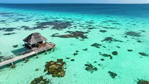
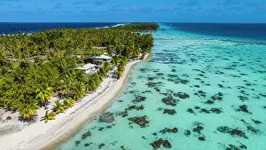
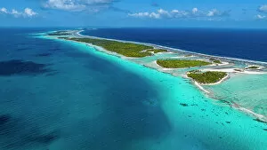
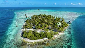
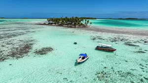
Experience the breathtaking beauty of the world from a drone's perspective. From high above, witness the stunning aerial panoramic of Cala Galdana beach in Menorca, Balearic Islands, Spain. The crystal-clear waters and golden sands stretch out before you, inviting you to dive into paradise. As the sun rises over Lake Bled in Slovenia, immerse yourself in its ethereal charm. The aerial view captures the serenity of this picturesque destination, with its emerald-green waters reflecting the vibrant colors of nature awakening. Discover the hidden gems of Menorca as you soar above Cala Macarella and Cala Macarelleta. These secluded coves offer an idyllic escape from reality, surrounded by cliffs and turquoise waters that seem straight out of a postcard. Mona Vale Rock Pool becomes a mesmerizing sight when viewed from a drone's lens. This unique formation nestled along Australia's coastline showcases nature's artistry at its finest – where waves crash against ancient rocks creating an awe-inspiring spectacle. Witness nature bidding farewell to another day as sunset paints Isola Bella on Lake Maggiore with warm hues. The tranquil atmosphere is further enhanced as Borromean islands come alive under the fading light – a true feast for your eyes captured through aerial photography. Crossing bridges takes on new meaning when seen from above Veliko Jezero lake. Aerial footage reveals intricate designs blending harmoniously with natural surroundings – reminding us that human ingenuity can coexist beautifully with Mother Nature. Embark on a spiritual journey as drones capture sunrise illuminating Holy Monastery of Varlaam - UNESCO World Heritage Site standing tall amidst rugged landscapes. Its architectural grandeur stands testament to centuries-old traditions preserved within these sacred walls. Travel back in time to Altit Village and Altit Fort in Hunza, Pakistan - their rich history unfolds beneath your feet while soaring high above them all.