Gold mask of Tutankhamun, Egyptian Museum, Cairo, Egypt, North Africa, Africa
The Rosetta Stone, British Museum, London, England, United Kingdom, Europe
Medieval Europe at the start of the CrusadesMap of Europe at the time of the First Crusade, 1097 AD. Printed color lithograph of a 19th-century illustration
Mural from the wall of the tomb-chapel of Nebamun near Thebes Egypt dates to around 1350 - 1400 BC. Painting shows Nebamun a little known nobleman hunting in the marshes of the Nile with daughter
Dugong (Dugong dugon) male feeding on a seagrass meadow (Halophila stipulacea), accompanied by a young Golden trevally (Gnathanodon speciosus). Marsa Nabaa, Marsa Alam, Egypt. Red Sea
Bas-relief of the Goddess Sekhmet, Temple of Seti I, Abydos, Egypt, North Africa, Africa
Map of the Roman EmpireMap showing the extent of the Roman Empire. Hand-colored woodcut of a 19th-century illustration
Statue of the ancient Egyptian god Bes, Temple at Dendera, Egypt, North Africa, Africa
Map of CyprusVintage 19th Century map of Cyprus in the eastern Mediterranean Sea
RF - Hawksbill sea turtle (Eretmochelys imbricata) swimming over a coral reef. Whilst a Predatory bandcheek wrasse (Oxycheilinus digrammus)
The Red PyramidView of the Red Pyramid at Dahshur necropolis near Cairo, Egypt
The Devilfish in Egyptian Waters. An American cartoon from 1882 depicting John Bull (England)IMPERIALISM CARTOON, 1882. The Devilfish in Egyptian Waters. An American cartoon from 1882 depicting John Bull (England) as the octopus of imperialism grabbing land on every continent
Icon of Mary and saints Theodoros and Georgios with angels. 6th cent. St Catherines Monastery, Sinai. EGYPT. NOTE: This image avail. up to 100MB. Call for details
Basbousa, Egyptian semolina cake, Middle Eastern food, Egypt, North Africa, Africa
Mena House Hotel, Giza, Cairo, Egypt
Map of EgyptIllustration of a Map of Egypt
Sunset at the Pyramids, Giza, Cairo, EgyptA sunset from the Pyramids at Giza, Cairo, Egypt
Goddess SekhmetSeated black granite statue of the lioness goddess Sekhmet from the Temple of Mut at Karnak, Egypt. It dates from the reign of Amenhotep III (Amenofis, Amenophis)
Arab empire, mid-700sEmpire of the Arab Caliphs, middle of the 8th century. Printed color lithograph
Pyramids along the NilePyramids at Gizeh, with dhows on the Nile River in Egypt. Hand-colored woodcut of a 19th-century illustration
Various African masks on sale at Aswan Souq, Aswan, Egypt, North Africa, Africa
Political map of The Middle EastVector illustration of the policital map of The Middle East Reference map was created by the US Central Intelligence Agency
City map of Alexandria, Egypt, lithograph, published in 1897City map of Alexandria, Egypt. Lithograph, published in 1897
Africa Political MapAntique illustration of a Africa Political Map from 1893
Sunset, Sphinx (foreground), The Pyramid of Chephren (background), The Pyramids of GizaGiza, Egypt
Statue of seated Ramses II, Court of Ramses II, Luxor Temple, Luxor, Thebes, UNESCO World Heritage Site, Egypt, North Africa, Africa
House of Axel Munthe, Villa San Michele, Anacapri, Capri, Campania, Italy, Europe
Egypt, Cairo, Giza, View of all three Great Pyramids at sunset
Kite surfing on Red Sea coast of Egypt, North Africa, Africa
Mosaic of St. George slaying the dragon in St. George Coptic Orthodox church, Cairo, Egypt, North Africa, Africa
Egyptian deities separating night and dayAncient Egyptian deities Shu separating Sibu and Nuit. Hand-colored 19th-century woodcut reproduction of a painting on a mummy-case
Tutankhamun, Egypt, North Africa, Africa
Codex Sinaiticus Syriacus dating from the 5th century, Monastery of St. Catherine, Sinai, Egypt, North Africa, Africa
Colossi of Ramses II, floodlit, Great Temple of Ramses II, Abu Simbel, UNESCO World Heritage Site, Egypt, North Africa, Africa
October 6th Bridge, Nile River, Cairo, Egypt, North Africa, Africa
The kings two daggers, one with a blade of gold, the other of iron, from the tomb of the pharaoh Tutankhamun, discovered in the Valley of the Kings, Thebes, Egypt, North Africa, Africa
One of the double doors of the gilt shrine showing the goddess Isis, from the tomb of the pharaoh Tutankhamun, discovered in the Valley of the Kings, Thebes, Egypt, North Africa, Africa
Pyramids at sunset, Giza, UNESCO World Heritage Site, near Cairo, Egypt, North Africa, Africa
Wanderings of the Israelites Map EngravingEngraved illustration of Wanderings of the Israelites Map Engraving from The Popular Pictorial Bible, Containing the Old and New Testaments, Published in 1862. Copyright has expired on this artwork
Deir al-Bahri, HatshepsutDayr el-Bahari or Dayr el-Bahri is a complex of temples and tombs on the west bank of the Nile. The complex is part of UNESCO World Heritage Sites
Mortuary Temple of Hatshepsut, Luxor, EgyptMortuary Temple of Hatshepsut, Deir el-Bahari, Theban Necropolis (UNESCO World Heritage List, 1979), Luxor, Egypt. Egyptian civilisation, New Kingdom, Dynasty XVIII
Homeric cosmogony. Map of the Earth based on the myths and knowledge of the Ancient Greeks at the time of Homer (1st or 2nd millennium BC)
Arabian Picasso triggerfish (Rhinecanthus assasi). The Arabian Picasso triggerfish is found in shallow, sandy areas of coral reefs in the western Indian Ocean
Mideast map during the CrusadesMap of the Middle East at the time of the Crusades. Printed color lithograph
Passover ritual as begun in ancient EgyptJewish family marking their home with lambs blood for the first Passover. Hand-colored woodcut of a 19th-century illustration
PANC2A-00003Map of the empire of Alexander the Great in 323 BC. Printed color lithograph of a 19th-century illustration
Sun-god Ra on his daily journey, ancient EgyptSun-god Ra embarking for his daily journey through Egypt. Hand-colored 19th-century woodcut reproduction of ancient Egyptian art
Mural from tomb-chapel of Nebamun at Thebes Egypt. Nebamun was an Ancient Egyptian Nobleman and this shows him overlooking geese brought to him and dates between 1350 - 1400 BC
Choose your image, Select your licence and Download the media
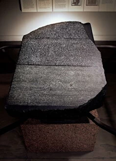
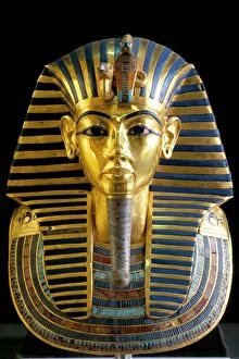
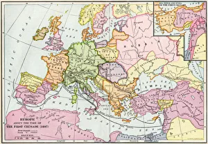
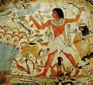
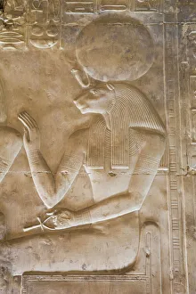
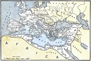
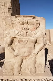
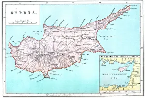
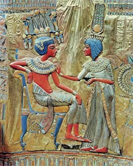
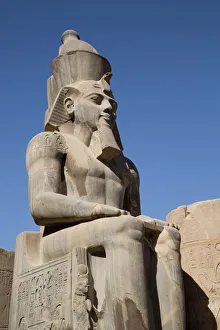
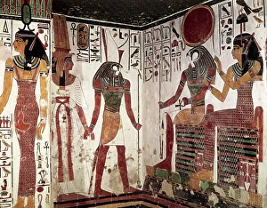
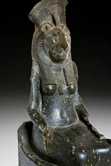
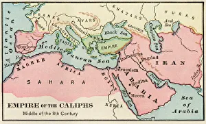
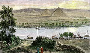
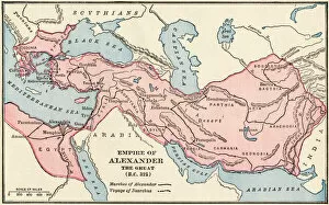
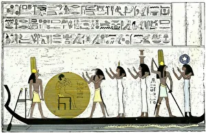
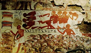
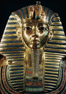