
German North Sea Region Collection

Discover the captivating German North Sea region through a journey of ancient maps and lithographs

Background imageGerman North Sea Region Collection: Antquie Map of Prussia

Antquie Map of Prussia
Vintage map of Prussia from 1837

Background imageGerman North Sea Region Collection: RAOEgen

RAOEgen
Antique map of RAOEgen

Background imageGerman North Sea Region Collection: 1883 British Isles Map

1883 British Isles Map

Background imageGerman North Sea Region Collection: Germania in 2 century after Christ

Germania in 2 century after Christ

Background imageGerman North Sea Region Collection: Grand Duchy of Oldenburg, litograph, published in 1877

Grand Duchy of Oldenburg, litograph, published in 1877
Ancient map of Grand Duchy of Oldenburg, Germany. Lithograph, published in 1877

Background imageGerman North Sea Region Collection: German Empire of 1871-1918, lithograph, published in 1875

German Empire of 1871-1918, lithograph, published in 1875
German Empire within the borders of 1871 - 1918. Lithograph, published in 1875

Background imageGerman North Sea Region Collection: Ancient Europe under Emporer Augstus (63 BC-14 AD), published 1861

Ancient Europe under Emporer Augstus (63 BC-14 AD), published 1861
Ancient map of Gaul, Germania and Britannia during the time of the first Roman Emporer Augstus (63 BC - 14 AD). Legend in Latin language. Steel engraving with colored borderlines, published in 1861

Background imageGerman North Sea Region Collection: Schleswig-Holstein, lithograph, published in 1878

Schleswig-Holstein, lithograph, published in 1878
Map of Schleswig-Holstein. Lithograph, published in 1878

Background imageGerman North Sea Region Collection: Map of Denmark and Iceland, lithograph, published in 1881

Map of Denmark and Iceland, lithograph, published in 1881
Topographic map of Denmark and Iceland. Facsimile, published in 1881

Background imageGerman North Sea Region Collection: Konigsberg

Konigsberg
Antique map of Konigsberg

Background imageGerman North Sea Region Collection: Leipzig

Leipzig
Antique illustration of a Leipzig from 1898

Background imageGerman North Sea Region Collection: Hannover, Schleswig-Holstein, Braunschweig and Oldenburg

Hannover, Schleswig-Holstein, Braunschweig and Oldenburg

Background imageGerman North Sea Region Collection: Prussia

Prussia
Antique illustration of a East-West West Prussia

Background imageGerman North Sea Region Collection: Nesting gannets on Helgoland, Germany

Nesting gannets on Helgoland, Germany
Northern Gannets (Sula bassana or Morus bassanus) on Helgoland. Males and females bond for life. Since 1991, the Northern Gannet inhabits the rocky cliffs of Helgoland

Background imageGerman North Sea Region Collection: Northern gannets on Helgoland, Germany

Northern gannets on Helgoland, Germany
Northern gannets (Sula bassana or Morus bassanus) on Helgoland. Since 1991, the Northern Gannet inhabits the rocky cliffs of Helgoland, a tiny island in the North Sea


For sale as Licensed Images

Choose your image, Select your licence and Download the media

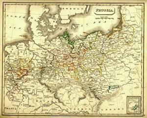
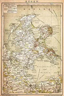
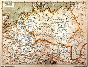
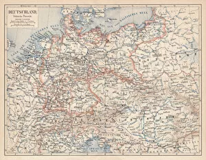
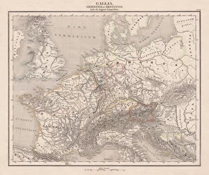
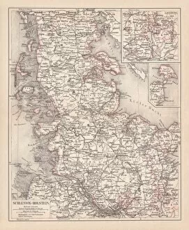
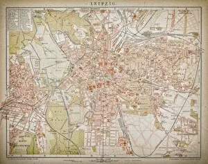
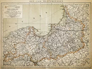
Discover the captivating German North Sea region through a journey of ancient maps and lithographs. Delve into history with an antique map of Prussia, showcasing the borders and territories that once defined this land. Immerse yourself in RAOEgen, a place where time seems to stand still, as you explore its rich cultural heritage. Transport yourself back to 1883 with a British Isles map, which offers insights into the historical connections between Germany and its neighboring countries. Witness Germania in the 2nd century after Christ, as depicted on an ancient European map published in 1861 during Emperor Augustus' reign. Marvel at Schleswig-Holstein's beauty through a lithograph from 1878, capturing the essence of this enchanting region. The Grand Duchy of Oldenburg comes alive in another lithograph from 1877, inviting you to discover its hidden treasures. Experience the grandeur of the German Empire from 1871-1918 through a lithograph published in 1875. Let your imagination soar as you trace Prussia's roots on an antique map while exploring Denmark and Iceland on another lithograph published in 1881. Uncover Konigsberg's secrets and immerse yourself in Leipzig's vibrant atmosphere – two cities that have played significant roles throughout history. From trade routes to intellectual hubs, these places hold stories waiting to be discovered. The German North Sea region is not just about geographical boundaries; it is a tapestry woven with tales of triumphs and challenges faced by generations past. Embark on this visual journey through time and let these maps ignite your curiosity for exploration like never before.