
Great Lakes Collection (#8)

"Discover the Majestic Beauty of the Great Lakes

Background imageGreat Lakes Collection: Snow cover stretching from Canada southward to West Virginia

Snow cover stretching from Canada southward to West Virginia
March 6, 2010 - Snow cover stretching from Canada southward to West Virginia. The navy blue of the eastern Great Lakes and the Atlantic Ocean contrasts with the snow cover in this true-color image

Background imageGreat Lakes Collection: Cloud-free weather over much of the eastern United States

Cloud-free weather over much of the eastern United States

Background imageGreat Lakes Collection: Cloud streets over Lake Superior and Lake Michigan

Cloud streets over Lake Superior and Lake Michigan
February 5, 2007 - Cloud streets over Lake Superior and Lake Michigan. These clouds occur when frigid, dry air blows across the lake, where it picks up water vapor from the warmer lake

Background imageGreat Lakes Collection: View from space of Lake Ontario

View from space of Lake Ontario
August 23, 2013 - View from space highlighting a late-summer whiting event visible across much of Lake Ontario. Such events are caused by changes in water temperature

Background imageGreat Lakes Collection: Satellite view of snow across Wisonsin, Michigan and Canada

Satellite view of snow across Wisonsin, Michigan and Canada
March 28, 2011 - The bright white remnants of snow cut a clean swath across Wisconsin and Michigan during springtime snowmelt

Background imageGreat Lakes Collection: Fall colors in the eastern United States

Fall colors in the eastern United States
November 8, 2009 - Fall colors in the eastern United States. This image shows the Great Lakes on the left side of the image, and Canada is to the north. The U.S

Background imageGreat Lakes Collection: Snow across the northeastern United States

Snow across the northeastern United States
March 3, 2009 - The U.S. East Coast was cleaning up after a storm that dumped up to a foot of snow on East Coast states from Georgia to Maine

Background imageGreat Lakes Collection: Satellite view of The Great Lakes

Satellite view of The Great Lakes

Background imageGreat Lakes Collection: High oblique view of Lake Michigan, Lake Huron and the state of Michigan

High oblique view of Lake Michigan, Lake Huron and the state of Michigan
July 11, 2013 - High oblique view of Lake Michigan, Lake Huron and most of the state of Michigan in between

Background imageGreat Lakes Collection: Satellite view of fog forming over the Great Lakes

Satellite view of fog forming over the Great Lakes
January 6, 2014 - Satellite view of fog forming over the Great Lakes and streaming southeast with the wind. A swirling mass of Arctic air moved south into the continental United States in early

Background imageGreat Lakes Collection: Satellite view of ice on the Great Lakes, United States

Satellite view of ice on the Great Lakes, United States
March 16, 2014 - Satellite view of ice on the Great Lakes, United States

Background imageGreat Lakes Collection: Queenston, On the Landing Between Lake Ontario and Lake Erie, from Ackermann s

Queenston, On the Landing Between Lake Ontario and Lake Erie, from Ackermann s
XIR241530 Queenston, On the Landing Between Lake Ontario and Lake Erie, from Ackermanns Repository of Arts, 1814 (coloured engraving) by English School, (19th century); Bibliotheque Nationale, Paris

Background imageGreat Lakes Collection: Construction of the Griffon of Rene Robert Cavelier de la Salle (1643-87)

Construction of the Griffon of Rene Robert Cavelier de la Salle (1643-87)
XIR187083 Construction of the Griffon of Rene Robert Cavelier de la Salle (1643-87) on the shore of Lake Erie, from Voyages Curieux de M. de Hennequin et de M

Background imageGreat Lakes Collection: Map of New France dedicated to Colbert by Duchesneau, Intendant, 1681 (engraving)

Map of New France dedicated to Colbert by Duchesneau, Intendant, 1681 (engraving)
XIR164768 Map of New France dedicated to Colbert by Duchesneau, Intendant, 1681 (engraving) (b/w photo) (see 164769 for detail) by Franquelin

Background imageGreat Lakes Collection: David Livingstone welcomed in a village in the Great Lakes region of Central Africa

David Livingstone welcomed in a village in the Great Lakes region of Central Africa
XIR1272815 David Livingstone welcomed in a village in the Great Lakes region of Central Africa, 1874 (engraving) by French School, (19th century); Bibliotheque Nationale, Paris

Background imageGreat Lakes Collection: Illinois, Chicago, Lake Michigan. Historic Chicago Harbor Light with Chicago city skyline

Illinois, Chicago, Lake Michigan. Historic Chicago Harbor Light with Chicago city skyline and Willis Tower in the distance

Background imageGreat Lakes Collection: RIVERBOAT, c1900. The steamboat City of Erie, which travelled the Cleveland and Buffalo line

RIVERBOAT, c1900. The steamboat City of Erie, which travelled the Cleveland and Buffalo line. Photochrome, c1900

Background imageGreat Lakes Collection: PETER POND (1740-1807). American fur trader and explorer

PETER POND (1740-1807). American fur trader and explorer. Copy, 1785, of Ponds map of the region between the Mississippi River and Hudson Bay

Background imageGreat Lakes Collection: MAP: THIRTEEN STATES. A map of the thirteen original American states, the Northwest Territory

MAP: THIRTEEN STATES. A map of the thirteen original American states, the Northwest Territory and Louisiana, as it appeared in the 1770s. Engraving, c1900

Background imageGreat Lakes Collection: LAND ORDINANCE, 1785. Map of the northwest parts of the United States according

LAND ORDINANCE, 1785. Map of the northwest parts of the United States according to the Land Ordinance adopted by the United States Congress, 20 May 1785

Background imageGreat Lakes Collection: SIOUX CHIEF, c1700. A Native American Sioux chief from the Great Lakes region. Drawing

SIOUX CHIEF, c1700. A Native American Sioux chief from the Great Lakes region. Drawing, c1700, by a French official while stationed in Canada

Background imageGreat Lakes Collection: WAR OF 1812: LAKE ONTARIO. Last page of a statement from the Navy Department

WAR OF 1812: LAKE ONTARIO. Last page of a statement from the Navy Department on the US Naval force on Lake Ontario, 6 June 1814, sent to President James Madison

Background imageGreat Lakes Collection: WAR OF 1812: LAKE ERIE. Listing of the US Naval force on Lake Erie, 6 June 1814

WAR OF 1812: LAKE ERIE. Listing of the US Naval force on Lake Erie, 6 June 1814, sent to President James Madison by the Navy Department

Background imageGreat Lakes Collection: WAR OF 1812: LAKE ONTARIO. Listing of the US Naval force on Lake Ontario, 6 June 1814

WAR OF 1812: LAKE ONTARIO. Listing of the US Naval force on Lake Ontario, 6 June 1814, sent to President James Madison by the Navy Department

Background imageGreat Lakes Collection: WAR OF 1812: CARTOON. John Bull bakes a new batch of ships to send to the Great Lakes

WAR OF 1812: CARTOON. John Bull bakes a new batch of ships to send to the Great Lakes. American cartoon, by William Charles, c1813

Background imageGreat Lakes Collection: Grain Boats

Grain Boats
November 1918: Boats carrying grain on the Great Lakes. (Photo by Topical Press Agency/Getty Images)

Background imageGreat Lakes Collection: A chart of the east coast of America and the Gulf Stream, printed by Benjamin Franklin, 1786

A chart of the east coast of America and the Gulf Stream, printed by Benjamin Franklin, 1786
GULF STREAM CHART, 1786. A chart of the east coast of America and the Gulf Stream, printed by Benjamin Franklin, 1786

Background imageGreat Lakes Collection: Map of Thomas Jeffersons proposed states, 1784

Map of Thomas Jeffersons proposed states, 1784
JEFFERSON: STATES, 1784. Map of Thomas Jeffersons proposed states, 1784

Background imageGreat Lakes Collection: Steamer, City of Toledo Postcard. ca. 1904, Steamer, City of Toledo Postcard

Steamer, City of Toledo Postcard. ca. 1904, Steamer, City of Toledo Postcard

Background imageGreat Lakes Collection: Lake Shore Drive, Gorden Park, Cleveland, Ohio Postcard. 1903, Lake Shore Drive, Gorden Park

Lake Shore Drive, Gorden Park, Cleveland, Ohio Postcard. 1903, Lake Shore Drive, Gorden Park, Cleveland, Ohio Postcard

Background imageGreat Lakes Collection: Unloading Coal, Duluth, Minn. Postcard. ca. 1915-1925, Unloading Coal, Duluth, Minn. Postcard

Unloading Coal, Duluth, Minn. Postcard. ca. 1915-1925, Unloading Coal, Duluth, Minn. Postcard

Background imageGreat Lakes Collection: Postcard of Men Fishing from a Small Boat. ca. 1913, Fishing at Saugatuck, Michigan

Postcard of Men Fishing from a Small Boat. ca. 1913, Fishing at Saugatuck, Michigan

Background imageGreat Lakes Collection: Str. Chippewa Postcard. ca. 1915-1925, Str. Chippewa Postcard

Str. Chippewa Postcard. ca. 1915-1925, Str. Chippewa Postcard

Background imageGreat Lakes Collection: Lake, Rail and Motor Transportation, Sault Ste Marie, Mich. Postcard. ca. 1915-1925, Lake

Lake, Rail and Motor Transportation, Sault Ste Marie, Mich. Postcard. ca. 1915-1925, Lake, Rail and Motor Transportation, Sault Ste Marie, Mich. Postcard

Background imageGreat Lakes Collection: Greeting Card from Huron, Ohio. ca. 1947, Huron, Ohio, USA, Greeting Card from Huron, Ohio

Greeting Card from Huron, Ohio. ca. 1947, Huron, Ohio, USA, Greeting Card from Huron, Ohio

Background imageGreat Lakes Collection: Lake Drive, Lincoln Park, Chicago, Ill. Postcard. ca. 1901, Lake Drive, Lincoln Park, Chicago

Lake Drive, Lincoln Park, Chicago, Ill. Postcard. ca. 1901, Lake Drive, Lincoln Park, Chicago, Ill. Postcard

Background imageGreat Lakes Collection: Postcard of Giant Freighter on Lake Superior. ca. 1917, Giant freighter steaming on Lake Superior

Postcard of Giant Freighter on Lake Superior. ca. 1917, Giant freighter steaming on Lake Superior, the largest fresh-water lake in the world

Background imageGreat Lakes Collection: Postcard of Cleveland near Lake Erie. ca. 1919, EAST 9TH STREET LOOKING TOWARDS LAKE ERIE

Postcard of Cleveland near Lake Erie. ca. 1919, EAST 9TH STREET LOOKING TOWARDS LAKE ERIE, CLEVELAND, OHIO

Background imageGreat Lakes Collection: Postcard of Airplane Flying over Beach at Cedar Point. ca. 1916

Postcard of Airplane Flying over Beach at Cedar Point. ca. 1916, FINEST FRESH WATER BEACH IN THE WORLD, CEDAR POINT, OHIO

Background imageGreat Lakes Collection: State of Wisconsin, United States, Relief Map

State of Wisconsin, United States, Relief Map
Relief map of the State of Wisconsin, United States. This image was compiled from data acquired by LANDSAT 5 & 7 satellites combined with elevation data

Background imageGreat Lakes Collection: State of Illinois, United States, True Colour Satellite Image

State of Illinois, United States, True Colour Satellite Image
Satellite view of the State of Illinois, United States. This image was compiled from data acquired by LANDSAT 5 & 7 satellites

Background imageGreat Lakes Collection: Rwanda, Relief Map with Border and Mask

Rwanda, Relief Map with Border and Mask
Relief map of Rwanda (with border and mask). This image was compiled from data acquired by landsat 5 & 7 satellites combined with elevation data

Background imageGreat Lakes Collection: United States, Relief Map with Border and Mask

United States, Relief Map with Border and Mask
Relief map of the United States (with border and mask). This image was compiled from data acquired by landsat 5 & 7 satellites combined with elevation data

Background imageGreat Lakes Collection: Uganda, Relief Map with Border and Mask

Uganda, Relief Map with Border and Mask
Relief map of Uganda (with border and mask). This image was compiled from data acquired by landsat 5 & 7 satellites combined with elevation data

Background imageGreat Lakes Collection: State of Indiana, United States, Relief Map

State of Indiana, United States, Relief Map
Relief map of the State of Indiana, United States. This image was compiled from data acquired by LANDSAT 5 & 7 satellites combined with elevation data

Background imageGreat Lakes Collection: Canada, Relief Map With Border and Mask

Canada, Relief Map With Border and Mask
Relief map of Canada (with border and mask). This image was compiled from data acquired by landsat 5 & 7 satellites combined with elevation data

Background imageGreat Lakes Collection: United States and Canada, Relief Map with Border

United States and Canada, Relief Map with Border
Relief map of the United States and Canada (with border). This image was compiled from data acquired by LANDSAT 5 & 7 satellites combined with elevation data

Background imageGreat Lakes Collection: Province of Ontario, Canada, True Colour Satellite Image

Province of Ontario, Canada, True Colour Satellite Image
Satellite view of Ontario, Canada. This image was compiled from data acquired by LANDSAT 5 & 7 satellites


For sale as Licensed Images

Choose your image, Select your licence and Download the media

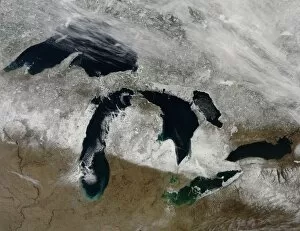
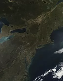
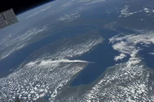
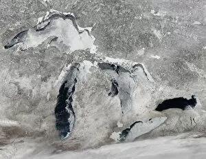
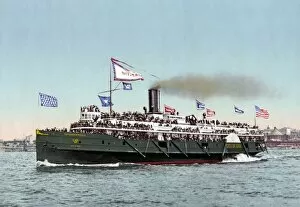
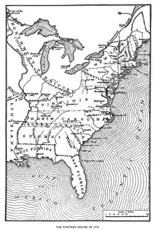
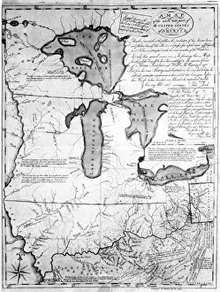
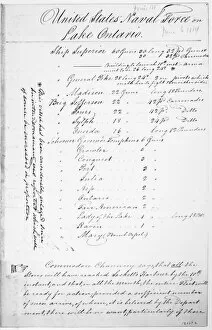
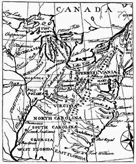
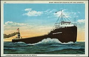
"Discover the Majestic Beauty of the Great Lakes: A Journey through History and Nature" Embark on a captivating journey as we explore the enchanting wonders of the Great Lakes region. Nestled within this picturesque landscape lies Sturgeon Bay Lighthouse, an iconic symbol of Door County, Wisconsin. Its towering presence serves as a beacon for sailors navigating these vast waters. Delve into history's depths and witness the echoes of the Battle of Lake Erie during the War of 1812. Feel a surge of patriotism as you imagine US Navy ships sailing bravely amidst turbulent waves near Sackets Harbor, New York in 1814. Experience tranquility under moonlit skies at Whitefish Point Lighthouse, casting its ethereal glow upon Lake Superior's shores. Marvel at EVNT2A-00196—a long exposure photograph capturing nature's raw beauty along Grand Marais' coastline—where time stands still in harmony with crashing waves. Gaze up to behold a celestial spectacle—the Milky Way Over Hollow Rock—illuminating Lake Michigan's night sky like an artist's brushstroke across canvas. Transport yourself back to centuries past with GREAT LAKES MAP, 1755—an exquisite French engraved map that unveils early explorations and settlements around these magnificent lakes. Prepare to be awe-struck by Niagara Falls' majestic cascade—a breathtaking sight where Waterfall Niagara Falls meets vibrant rainbows in Canada, Ontario. Immerse yourself in TRAN2A-00040—an immersive experience that transports you deep beneath these cascading waters. Witness resilience amidst adversity as a grain boat braves treacherous snowstorms on Lake Erie—a testament to human determination against nature's fury captured forever in EXPL2A-00128. The Great Lakes region is more than just water—it is an embodiment of history, natural splendor, and boundless adventures waiting to be discovered. So come forth and let your senses be captivated by this extraordinary tapestry of land and water.