
Lake Michigan Collection (#6)
"Captivating Lake Michigan: A Tapestry of Beauty and History" From the iconic Sturgeon Bay Lighthouse in Door County


For sale as Licensed Images
Choose your image, Select your licence and Download the media
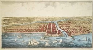
"Captivating Lake Michigan: A Tapestry of Beauty and History" From the iconic Sturgeon Bay Lighthouse in Door County, Wisconsin to the breathtaking Grand Haven South Pier Lighthouse at sunrise in Ottawa County, Michigan, Lake Michigan boasts a mesmerizing blend of natural wonders and man-made marvels. As the sun paints the sky with hues of gold and orange, the Grand Haven Lighthouse on Lake Michigan stands tall, guiding ships through its tranquil waters. Meanwhile, Chicago's majestic skyline reflects upon the shimmering surface at dusk, with the Willis Tower (formerly Sears Tower) dominating the left side. In Berrien County's St. Joseph lies a picturesque scene where St. Joseph lighthouse gracefully overlooks a pristine beach foreground. Further along Chicago's shoreline is another architectural gem - Chicago Harbor Lighthouse - standing as a testament to maritime history. Navy Pier proudly extends into Lake Michigan from Chicago's shores while offering visitors an array of entertainment options against an awe-inspiring backdrop. And speaking of backdrops, Illinois' 1852 Map showcases how this great lake has played a pivotal role in shaping our nation's growth. Let us not forget Point Betsie Lighthouse in Benzie County, Frankfort - a beacon that has guided countless sailors home safely throughout history. Lake Michigan serves as more than just a body of water; it is an enchanting tapestry woven with threads of nature’s beauty and human ingenuity. Whether you find yourself exploring its shores or gazing out from afar, this magnificent lake will forever captivate your heart and soul.