
Lieutenant Colonel Sir Mark Sykes Collection (#2)
Lieutenant Colonel Sir Mark Sykes, a man of many talents and interests, delved into the captivating world of dynasties in the time of the Buwayids


For sale as Licensed Images
Choose your image, Select your licence and Download the media
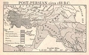
Lieutenant Colonel Sir Mark Sykes, a man of many talents and interests, delved into the captivating world of dynasties in the time of the Buwayids. With his keen eye for historical detail, he brought to life this era that unfolded around 932 A. D. , juxtaposing it with the tumultuous events of c1915. Intrigued by the clash between Byzantine and Crusaders against Seljuks circa 1130 A. D. , Sykes meticulously examined every aspect, shedding light on this epic confrontation through his work created by Emery Walker Ltd. His dedication to historical accuracy was evident as he unraveled the complexities surrounding these rival factions. Venturing further into uncharted territories, Sykes explored Neri to Akra in c1915. Through Stanfords Geographical Establishment's creation, he unearthed hidden secrets and unveiled forgotten tales from this enigmatic region. His thirst for knowledge knew no bounds as he pieced together fragments of history. Sykes' insatiable curiosity led him to delve deep into Baghdad in the Days of Mansur in 1915. Collaborating with Edmund Sandars, he skillfully reconstructed a vivid image of this ancient city during its golden age under Mansur's rule. His attention to detail transported readers back in time, immersing them within its bustling streets. The Ottoman Empire held a special fascination for Sykes; thus, he dedicated himself to studying its evolution after 1450 A. D. , leaving no stone unturned. Emery Walker Ltd. 's collaboration allowed him to present an intricate tapestry depicting how this empire transformed over centuries—a testament to his commitment towards unraveling historical intricacies. With an unknown creator behind Physical Map of the Ottoman Empire circa 1915 at his disposal, Sykes utilized it as a tool for understanding territorial boundaries and geopolitical dynamics that shaped history. He deciphered each line and contour with precision—an invaluable resource for scholars and enthusiasts alike.