
Map Bounded By Collection (#9)

"Exploring the Intricate Map Boundaries of Brooklyn: Unveiling Hidden Gems in Ward 29

Background imageMap Bounded By Collection: Plate 29: Map bounded by Joralemon Street, Fulton Street, Smith Street, Atlantic Avenue

Plate 29: Map bounded by Joralemon Street, Fulton Street, Smith Street, Atlantic Avenue, Hoyt Street, Bergen Street, Court Street. 1855, William Perris, Brooklyn, New York, N.Y. USA

Background imageMap Bounded By Collection: Plate 31: Map bounded by Warren Street, Nevins Street, Union Street, Hoyt Street

Plate 31: Map bounded by Warren Street, Nevins Street, Union Street, Hoyt Street. 1855, William Perris, Brooklyn, New York, N.Y. USA

Background imageMap Bounded By Collection: Plate 30: Map bounded by Bergen Steet, Hoyt Street, Degraw Street, Court Street. 1855

Plate 30: Map bounded by Bergen Steet, Hoyt Street, Degraw Street, Court Street. 1855, William Perris, Brooklyn, New York, N.Y. USA

Background imageMap Bounded By Collection: Plate 26: Map bounded by Schermerhorn Street, Powers Street, Fulton Avenue, Lafayette

Plate 26: Map bounded by Schermerhorn Street, Powers Street, Fulton Avenue, Lafayette Street, Raymond Street, 4th Avenue, Wyckoff Street, Hoyt Street. 1855, William Perris, Brooklyn, New York, N.Y

Background imageMap Bounded By Collection: Plate 28: Map bounded by Willoughby Street, Gold Street, Fulton Avenue, Bond Street

Plate 28: Map bounded by Willoughby Street, Gold Street, Fulton Avenue, Bond Street, Schermerhorn Street, Hoyt Street, Jay Street. 1855, William Perris, Brooklyn, New York, N.Y. USA

Background imageMap Bounded By Collection: Plate 25: Map bounded by Willoughby Street, Raymond Street, Lafayette Avenue, Flatbush

Plate 25: Map bounded by Willoughby Street, Raymond Street, Lafayette Avenue, Flatbush Avenue, Powers Street, Schermerhorn Street, Bond Street, Fulton Avenue, Gold Street

Background imageMap Bounded By Collection: Plate 23: Map bounded by Lafayette Avenue, Cumberland Street, Atlantic Avenue, 4th Avenue

Plate 23: Map bounded by Lafayette Avenue, Cumberland Street, Atlantic Avenue, 4th Avenue, Raymond Street. 1855, William Perris, Brooklyn, New York, N.Y. USA

Background imageMap Bounded By Collection: Plate 24: Map bounded by Myrtle Avenue, Cumberland Street, Lafayette Avenue, Raymond

Plate 24: Map bounded by Myrtle Avenue, Cumberland Street, Lafayette Avenue, Raymond Street. 1855, William Perris, Brooklyn, New York, N.Y. USA

Background imageMap Bounded By Collection: Plate 22: Map bounded by Myrtle Avenue, Clinton Street, Lafayette Avenue, Cumberland

Plate 22: Map bounded by Myrtle Avenue, Clinton Street, Lafayette Avenue, Cumberland Street. 1855, William Perris, Brooklyn, New York, N.Y. USA

Background imageMap Bounded By Collection: Plate 20: Map bounded by Flushing Avenue, Cumberland Street, Myrtle Avenue, Raymond

Plate 20: Map bounded by Flushing Avenue, Cumberland Street, Myrtle Avenue, Raymond Street, Park Avenue, Navy Street. 1855, William Perris, Brooklyn, New York, N.Y. USA

Background imageMap Bounded By Collection: Plate 19: Map bounded by Concord Street, Navy Street, Park Avenue, Raymond Street

Plate 19: Map bounded by Concord Street, Navy Street, Park Avenue, Raymond Street, Willoughby Street, Duffield Street. 1855, William Perris, Brooklyn, New York, N.Y. USA

Background imageMap Bounded By Collection: Plate 21: Map bounded by Flushing Avenue, Clinton Avenue, Myrtle Avenue, Cumberland

Plate 21: Map bounded by Flushing Avenue, Clinton Avenue, Myrtle Avenue, Cumberland Street. 1855, William Perris, Brooklyn, New York, N.Y. USA

Background imageMap Bounded By Collection: Plate 6: Map bounded by Poplar Street, Henry Street. 1855, William Perris, Brooklyn

Plate 6: Map bounded by Poplar Street, Henry Street. 1855, William Perris, Brooklyn, New York, N.Y. USA

Background imageMap Bounded By Collection: Plate 10: Map bounded by Hamilton Avenue, Van Brunt Street, Clinton Wharf, Buttermilk

Plate 10: Map bounded by Hamilton Avenue, Van Brunt Street, Clinton Wharf, Buttermilk Channel. 1855, William Perris, Brooklyn, New York, N.Y. USA

Background imageMap Bounded By Collection: Plate 4: Map bounded by East River, Bridge Street, York Street, Main Street. 1855

Plate 4: Map bounded by East River, Bridge Street, York Street, Main Street. 1855, William Perris, Brooklyn, New York, N.Y. USA

Background imageMap Bounded By Collection: Plate 2: Map bounded by South 8th Street, 1st Street, Division Street, Devoe Street

Plate 2: Map bounded by South 8th Street, 1st Street, Division Street, Devoe Street, Union Avenue, Ainslie Street, 1st Street, 9th Street, Smith Street, Messerole Street, Scholl Street

Background imageMap Bounded By Collection: Plate 3: Map bounded by East River, Brooklyn Navy Yard, York Street, Bridge Street

Plate 3: Map bounded by East River, Brooklyn Navy Yard, York Street, Bridge Street. 1855, William Perris, Brooklyn, New York, N.Y. USA

Background imageMap Bounded By Collection: Plate 1: Map bounded by North 12th Street, 1st Street, North 5th Street, Wythe Street

Plate 1: Map bounded by North 12th Street, 1st Street, North 5th Street, Wythe Street, North 3rd Street, 1st Street, South 7th Street, East River. 1855, William Perris, Brooklyn, New York, N.Y. USA

Background imageMap Bounded By Collection: Plate 85: Map bounded by West 27th Street, Sixth Avenue, West 22nd Street, Eighth Avenue

Plate 85: Map bounded by West 27th Street, Sixth Avenue, West 22nd Street, Eighth Avenue. 1857, 1862, Perris and Browne, New York, USA

Background imageMap Bounded By Collection: Plate 89: Map bounded by West 32nd Street, Eighth Avenue, West 27th Street, Tenth Avenue

Plate 89: Map bounded by West 32nd Street, Eighth Avenue, West 27th Street, Tenth Avenue. 1857, 1862, Perris and Browne, New York, USA

Background imageMap Bounded By Collection: Plate 82: Map bounded by East 52nd Street, East River, East 47th Street, Second Avenue

Plate 82: Map bounded by East 52nd Street, East River, East 47th Street, Second Avenue. 1857, 1862, Perris and Browne, New York, USA

Background imageMap Bounded By Collection: Plate 84: Map bounded by West 52nd Street, East 52nd Street, Fourth Avenue, East

Plate 84: Map bounded by West 52nd Street, East 52nd Street, Fourth Avenue, East 52nd Street, West 52nd Street, Sixth Avenue. 1857, 1862, Perris and Browne, New York, USA

Background imageMap Bounded By Collection: Plate 83: Map bounded by East 52nd Street, Second Avenue, 47th Street, Fourth Avenue

Plate 83: Map bounded by East 52nd Street, Second Avenue, 47th Street, Fourth Avenue. 1857, 1862, Perris and Browne, New York, USA

Background imageMap Bounded By Collection: Plate 88: Map bounded by West 32nd Street, Sixth Avenue, West 27th Street, Eighth Avenue

Plate 88: Map bounded by West 32nd Street, Sixth Avenue, West 27th Street, Eighth Avenue. 1857, 1862, Perris and Browne, New York, USA

Background imageMap Bounded By Collection: Plate 95: Map bounded by West 42nd Street, Eighth Avenue, West 37th Street, Tenth Avenue

Plate 95: Map bounded by West 42nd Street, Eighth Avenue, West 37th Street, Tenth Avenue. 1857, 1862, Perris and Browne, New York, USA

Background imageMap Bounded By Collection: Plate 86: Map bounded by West 27th Street, Eighth Avenue, West 22nd Street, Tenth Avenue

Plate 86: Map bounded by West 27th Street, Eighth Avenue, West 22nd Street, Tenth Avenue. 1857, 1862, Perris and Browne, New York, USA

Background imageMap Bounded By Collection: Plate 94: Map bounded by West 42nd Street, Sixth Avenue, West 37th Street, Eighth Avenue

Plate 94: Map bounded by West 42nd Street, Sixth Avenue, West 37th Street, Eighth Avenue. 1857, 1862, Perris and Browne, New York, USA

Background imageMap Bounded By Collection: Plate 92: Map bounded by West 37th Street, Eighth Avenue, West 32nd Street, Tenth Avenue

Plate 92: Map bounded by West 37th Street, Eighth Avenue, West 32nd Street, Tenth Avenue. 1857, 1862, Perris and Browne, New York, USA

Background imageMap Bounded By Collection: Plate 91: Map bounded by West 37th Street, Sixth Avenue, West 32nd Street, Eighth Avenue

Plate 91: Map bounded by West 37th Street, Sixth Avenue, West 32nd Street, Eighth Avenue. 1857, 1862, Perris and Browne, New York, USA

Background imageMap Bounded By Collection: Plate 79: Map bounded by East 47th Street, East River, East 42nd Street, Second Avenue

Plate 79: Map bounded by East 47th Street, East River, East 42nd Street, Second Avenue. 1857, 1862, Perris and Browne, New York, USA

Background imageMap Bounded By Collection: Plate 80: Map bounded by East 47th Street, Second Avenue, East 42nd Street, Fourth Avenue

Plate 80: Map bounded by East 47th Street, Second Avenue, East 42nd Street, Fourth Avenue. 1857, 1862, Perris and Browne, New York, USA

Background imageMap Bounded By Collection: Plate 74: Map bounded by East 37th Street, Second Avenue, East 32nd Street, Fourth Avenue

Plate 74: Map bounded by East 37th Street, Second Avenue, East 32nd Street, Fourth Avenue. 1857, 1862, Perris and Browne, New York, USA

Background imageMap Bounded By Collection: Plate 78: Map bounded by West 42nd Street, East 42nd Street, Fourth Avenue, East

Plate 78: Map bounded by West 42nd Street, East 42nd Street, Fourth Avenue, East 37th Street, West 37th Street, Sixth Avenue. 1857, 1862, Perris and Browne, New York, USA

Background imageMap Bounded By Collection: Plate 72: Map bounded by West 32nd Street, East 32nd Street, Fourth Avenue, East

Plate 72: Map bounded by West 32nd Street, East 32nd Street, Fourth Avenue, East 27th Street, West 27th Street, Sixth Avenue. 1857, 1862, Perris and Browne, New York, USA

Background imageMap Bounded By Collection: Plate 77: Map bounded by East 42nd Street, Second Avenue, East 37th Street, Fourth Avenue

Plate 77: Map bounded by East 42nd Street, Second Avenue, East 37th Street, Fourth Avenue. 1857, 1862, Perris and Browne, New York, USA

Background imageMap Bounded By Collection: Plate 75: Map bounded by West 37th Street, East 37th Street, Fourth Avenue, East

Plate 75: Map bounded by West 37th Street, East 37th Street, Fourth Avenue, East 32nd Street, West 32nd Street, Sixth Avenue. 1857, 1862, Perris and Browne, New York, USA

Background imageMap Bounded By Collection: Plate 69: Map bounded by West 27th Street, East 27th Street, Fourth Avenue, East

Plate 69: Map bounded by West 27th Street, East 27th Street, Fourth Avenue, East 22nd Street, West 22nd Street, Sixth Avenue. 1857, 1862, Perris and Browne, New York, USA

Background imageMap Bounded By Collection: Plate 76: Map bounded by East 42nd Street, East River, East 37th Street, Second Avenue

Plate 76: Map bounded by East 42nd Street, East River, East 37th Street, Second Avenue. 1857, 1862, Perris and Browne, New York, USA

Background imageMap Bounded By Collection: Plate 71: Map bounded by East 32nd Street, Second Avenue, East 27th Street, Fourth Avenue

Plate 71: Map bounded by East 32nd Street, Second Avenue, East 27th Street, Fourth Avenue. 1857, 1862, Perris and Browne, New York, USA

Background imageMap Bounded By Collection: Plate 70: Map bounded by East 32nd Street, East River, East 26th Street, Second Avenue

Plate 70: Map bounded by East 32nd Street, East River, East 26th Street, Second Avenue. 1857, 1862, Perris and Browne, New York, USA

Background imageMap Bounded By Collection: Plate 64: Map bounded by West 22nd Street, Sixth Avenue, West 17th Street, Eight Avenue

Plate 64: Map bounded by West 22nd Street, Sixth Avenue, West 17th Street, Eight Avenue. 1857, 1862, Perris and Browne, New York, USA

Background imageMap Bounded By Collection: Plate 65: Map bounded by West 22nd Street, Eighth Avenue, West 17th Street, Tenth Avenue

Plate 65: Map bounded by West 22nd Street, Eighth Avenue, West 17th Street, Tenth Avenue. 1857, 1862, Perris and Browne, New York, USA

Background imageMap Bounded By Collection: Plate 66: Map bounded by West 19th Street, Tenth Avenue, West 12th Street, Hudson River

Plate 66: Map bounded by West 19th Street, Tenth Avenue, West 12th Street, Hudson River. 1857, 1862, Perris and Browne, New York, USA

Background imageMap Bounded By Collection: Plate 59: Map bounded by 12th Street, Sixth Avenue, West Washington Place, 4th Street

Plate 59: Map bounded by 12th Street, Sixth Avenue, West Washington Place, 4th Street, Perry Street, Greenwich Avenue, Seventh Avenue, 12th Street. 1857, 1862, Perris and Browne, New York, USA

Background imageMap Bounded By Collection: Plate 61: Map bounded by West 12th Street, Gansevoort Street, Hudson Street, Bank Street

Plate 61: Map bounded by West 12th Street, Gansevoort Street, Hudson Street, Bank Street, Hudson River. 1857, 1862, Perris and Browne, New York, USA

Background imageMap Bounded By Collection: Plate 60: Map bounded by West 13th Street, Greenwich Avenue, 12th Street, Seventh Avenue

Plate 60: Map bounded by West 13th Street, Greenwich Avenue, 12th Street, Seventh Avenue, Greenwich Avenue, Perry Street, 4th Street, Charles Street, Bleeker Street, Hudson Street, Gansevoort Street

Background imageMap Bounded By Collection: Plate 58: Map bounded by 14th Street, University Place, 9th Street, Sixth Avenue

Plate 58: Map bounded by 14th Street, University Place, 9th Street, Sixth Avenue. 1857, 1862, Perris and Browne, New York, USA

Background imageMap Bounded By Collection: Plate 62: Map bounded by West 17th Street, Sixth Avenue, 12th Street, Greenwich Avenue

Plate 62: Map bounded by West 17th Street, Sixth Avenue, 12th Street, Greenwich Avenue, Eighth Avenue. 1857, 1862, Perris and Browne, New York, USA


For sale as Licensed Images

Choose your image, Select your licence and Download the media

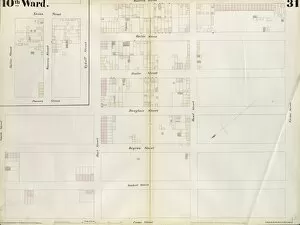
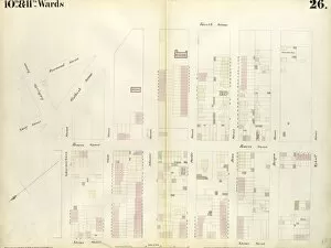
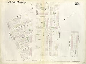
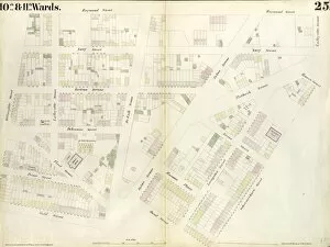
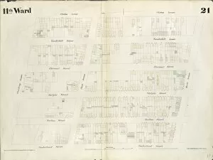
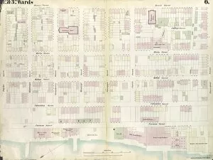
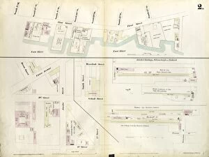
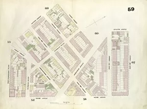
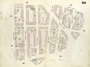
"Exploring the Intricate Map Boundaries of Brooklyn: Unveiling Hidden Gems in Ward 29, Section 15 & 16" Embark on a captivating journey through the vibrant streets of Brooklyn as we dive into the mesmerizing map bounded by Vol. 5, Double Page Plate No. 14. This enchanting part of Ward 29, Section 15 & 16 reveals a tapestry of diverse neighborhoods and cultural landmarks waiting to be discovered. "Dive into History: Unraveling the Secrets within Brooklyn's Ward 31, Section 21" Uncover the rich historical tapestry woven within the boundaries of Vol. 7, Double Page Plate No. 24 as we delve deep into Part of Ward 31, Section 21. Immerse yourself in this fascinating district that holds tales from yesteryears and offers a glimpse into Brooklyn's past. "Unlocking Hidden Treasures: Exploring Ward 31's Sections19 &21 through an Exquisite Map" Prepare to be captivated by the hidden gems nestled within Vol. 7, Double Page Plate No. 23 - Part of Ward 31, Sections19 &21. Embark on an adventure where history meets modernity and explore this remarkable area that is bound to leave you awe-inspired. "A Tapestry of Neighborhoods: Discovering Wards31&32'sSection20 via an Intriguing Map" Step foot onto uncharted territory with Vol. 7, Double Page Plate No. 15 - PartofWards31&32. Section20;Map bounded. Traverse through these interconnected neighborhoods and witness their unique charm unfold before your eyes. "Unveiling Enigmatic Pathways: Journey Through Brooklyn's Ward31-Section20 Bounded by E. " Get ready for an expedition like no other as we navigate our way through mysterious paths enclosed within Vol. 7, DoublePagePlateNo17. PartofWard31. Section22. MapboundedbyE.