Maps Collection (page 100)

Maps have always been a fascinating window into the past, allowing us to explore and understand the world as it once was

Background imageMaps Collection: Plan of the Inner Dock, Southampton (engraving)

Plan of the Inner Dock, Southampton (engraving)
1610037 Plan of the Inner Dock, Southampton (engraving) by English School, (19th century); Private Collection; (add.info.: Plan of the Inner Dock, Southampton)

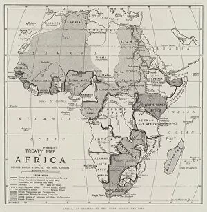
Background imageMaps Collection: Treaty Map of Africa (engraving)

Treaty Map of Africa (engraving)
1606524 Treaty Map of Africa (engraving) by English School, (19th century); Private Collection; (add.info.: Treaty Map of Africa. Illustration for The Illustrated London News, 24 September 1898)

Background imageMaps Collection: The Union of the Pacific and the Atlantic (engraving)

The Union of the Pacific and the Atlantic (engraving)
1607290 The Union of the Pacific and the Atlantic (engraving) by English School, (19th century); Private Collection; (add.info.: The Union of the Pacific and the Atlantic)

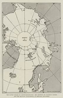
Background imageMaps Collection: The Latest Stages of Arctic Exploration, Map showing Dr Nansens Course

The Latest Stages of Arctic Exploration, Map showing Dr Nansens Course and the Relative Attainments of Previous
1605702 The Latest Stages of Arctic Exploration, Map showing Dr Nansens Course and the Relative Attainments of Previous Explorers (engraving) by English School

Background imageMaps Collection: Section of a Map of South Africa, including Pitsani (whence Jameson started), Mafeking, Pretoria

Section of a Map of South Africa, including Pitsani (whence Jameson started), Mafeking, Pretoria
1605487 Section of a Map of South Africa, including Pitsani (whence Jameson started), Mafeking, Pretoria, and Johannesburg (engraving) by English School

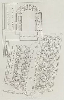
Background imageMaps Collection: Great Industrial Exhibition in Dublin (engraving)

Great Industrial Exhibition in Dublin (engraving)
1601836 Great Industrial Exhibition in Dublin (engraving) by Dower, John (fl.c.1845-55); Private Collection; (add.info.: Great Industrial Exhibition in Dublin)

Background imageMaps Collection: Fortifications of Bomarsund (engraving)

Fortifications of Bomarsund (engraving)
1607676 Fortifications of Bomarsund (engraving) by English School, (19th century); Private Collection; (add.info.: Fortifications of Bomarsund)

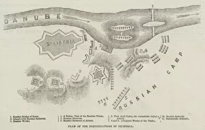
Background imageMaps Collection: Plan of the Fortifications of Silistria (engraving)

Plan of the Fortifications of Silistria (engraving)
1607568 Plan of the Fortifications of Silistria (engraving) by English School, (19th century); Private Collection; (add.info.: Plan of the Fortifications of Silistria)

Background imageMaps Collection: Battles of the British Army, Malplaquet (litho)

Battles of the British Army, Malplaquet (litho)
1605948 Battles of the British Army, Malplaquet (litho) by Woodville, Richard Caton II (1856-1927) (after); Private Collection; (add.info.: Battles of the British Army, Malplaquet)

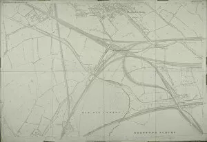
Background imageMaps Collection: Map of Willesden, London (litho)

Map of Willesden, London (litho)
1762027 Map of Willesden, London (litho) by English School; London Metropolitan Archives, City of London; (add.info.: Willesden is an area in North West London which forms part of the London Borough)

Background imageMaps Collection: Map of Willesden, London (litho)

Map of Willesden, London (litho)
1762021 Map of Willesden, London (litho) by English School; London Metropolitan Archives, City of London; (add.info.: Willesden is an area in North West London which forms part of the London Borough)

Background imageMaps Collection: A seller of geographical maps (engraving)

A seller of geographical maps (engraving)
2334811 A seller of geographical maps (engraving) by Unknown Artist, (19th century); (add.info.: A peddler of images hanging from the shoulder with geographic maps.); out of copyright

Background imageMaps Collection: L horloge (colour litho)

L horloge (colour litho)
5205003 L horloge (colour litho) by Fraipont, Gustave (1849-after 1897); Private Collection; (add.info.: L horloge. Illustration for Le Vocabulaire des Petits by M Fournier with designs by G[ustave])

Background imageMaps Collection: L ecole (colour litho)

L ecole (colour litho)
5204992 L ecole (colour litho) by Fraipont, Gustave (1849-after 1897); Private Collection; (add.info.: L ecole. Illustration for Le Vocabulaire des Petits by M Fournier with designs by G[ustave])

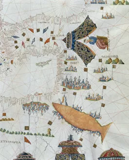
Background imageMaps Collection: A Nautical Map, detail of the Gran Turco, 1564 (colour litho)

A Nautical Map, detail of the Gran Turco, 1564 (colour litho)
955466 A Nautical Map, detail of the Gran Turco, 1564 (colour litho) by Maggiolo, Giacomo (16th Century); Biblioteca Civica Bertoliana, Vicenza, Italy; Alinari

Background imageMaps Collection: Europe, 1814 (litho)

Europe, 1814 (litho)
955444 Europe, 1814 (litho) by Bower, John (fl.1810-19); New York Public Library, USA; (add.info.: Published by Mathew Carey (1760-1839)); American, out of copyright

Background imageMaps Collection: Map of Rutland (colour engraving)

Map of Rutland (colour engraving)
979826 Map of Rutland (colour engraving) by English School, (18th century); Private Collection; (add.info.: Map of Rutland)

Background imageMaps Collection: Map of the East Riding of Yorkshire (colour engraving)

Map of the East Riding of Yorkshire (colour engraving)
979803 Map of the East Riding of Yorkshire (colour engraving) by Morden, Robert (fl.1682-1703); Private Collection; (add.info.: Map of the East Riding of Yorkshire, by Robert Morden)

Background imageMaps Collection: Map of Durham (colour engraving)

Map of Durham (colour engraving)
979802 Map of Durham (colour engraving) by Morden, Robert (fl.1682-1703); Private Collection; (add.info.: Map of Durham (Episdopaius Dunelmensis vulgo the Bishoprick of Durham), by Robert Morden

Background imageMaps Collection: Timber (colour litho)

Timber (colour litho)
3648666 Timber (colour litho) by English School, (20th century); Private Collection; (add.info.: Timber. Illustration for Atlas of the Worlds Commerce compiled from the latest official returns at)

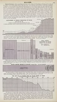
Background imageMaps Collection: Silver (colour litho)

Silver (colour litho)
3648658 Silver (colour litho) by English School, (20th century); Private Collection; (add.info.: Silver. Illustration for Atlas of the Worlds Commerce compiled from the latest official returns at)

Background imageMaps Collection: Cotton, growing countries (colour litho)

Cotton, growing countries (colour litho)
3648637 Cotton, growing countries (colour litho) by English School, (20th century); Private Collection; (add.info.: Cotton, growing countries)

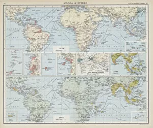
Background imageMaps Collection: Cocoa and spices (colour litho)

Cocoa and spices (colour litho)
3648624 Cocoa and spices (colour litho) by English School, (20th century); Private Collection; (add.info.: Cocoa and spices)

Background imageMaps Collection: Wine (colour litho)

Wine (colour litho)
3648617 Wine (colour litho) by English School, (20th century); Private Collection; (add.info.: Wine. Illustration for Atlas of the Worlds Commerce compiled from the latest official returns at)

Background imageMaps Collection: Postal map, 1907, Currency map (colour litho)

Postal map, 1907, Currency map (colour litho)
3648591 Postal map, 1907, Currency map (colour litho) by English School, (20th century); Private Collection; (add.info.: Postal map, 1907)

Background imageMaps Collection: International railways, length of railways in the principal countries of the world (colour litho)

International railways, length of railways in the principal countries of the world (colour litho)
3648589 International railways, length of railways in the principal countries of the world (colour litho) by English School, (20th century); Private Collection; (add.info.: International railways)

Background imageMaps Collection: International shipping, mercantile marine of the principal nations (colour litho)

International shipping, mercantile marine of the principal nations (colour litho)
3648588 International shipping, mercantile marine of the principal nations (colour litho) by English School, (20th century); Private Collection; (add.info.: International shipping)

Background imageMaps Collection: Languages of commerce (colour litho)

Languages of commerce (colour litho)
3648576 Languages of commerce (colour litho) by English School, (20th century); Private Collection; (add.info.: Languages of commerce)

Background imageMaps Collection: Commercial growth of nations (colour litho)

Commercial growth of nations (colour litho)
3648573 Commercial growth of nations (colour litho) by English School, (20th century); Private Collection; (add.info.: Commercial growth of nations)

Background imageMaps Collection: England and Wales, ecclesiastical divisions (colour litho)

England and Wales, ecclesiastical divisions (colour litho)
3648444 England and Wales, ecclesiastical divisions (colour litho) by English School, (20th century); Private Collection; (add.info.: England and Wales, ecclesiastical divisions)

Background imageMaps Collection: Coal and iron (colour litho)

Coal and iron (colour litho)
3648433 Coal and iron (colour litho) by English School, (20th century); Private Collection; (add.info.: Coal and iron. Illustration for The Survey Gazetteer of the British Isles, Topographical)

Background imageMaps Collection: Distribution of land under crops, Distribution of pasture land (colour litho)

Distribution of land under crops, Distribution of pasture land (colour litho)
3648413 Distribution of land under crops, Distribution of pasture land (colour litho) by English School, (20th century); Private Collection; (add.info)

Background imageMaps Collection: Railways of Scotland (colour litho)

Railways of Scotland (colour litho)
3648412 Railways of Scotland (colour litho) by English School, (20th century); Private Collection; (add.info.: Railways of Scotland)

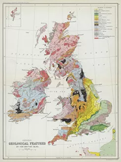
Background imageMaps Collection: General geological features of the British Isles (colour litho)

General geological features of the British Isles (colour litho)
3648401 General geological features of the British Isles (colour litho) by English School, (20th century); Private Collection; (add.info.: General geological features of the British Isles)

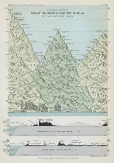
Background imageMaps Collection: Diagram showing comparative heights of mountains places etc in the British Isles (colour litho)

Diagram showing comparative heights of mountains places etc in the British Isles (colour litho)
3648398 Diagram showing comparative heights of mountains places etc in the British Isles (colour litho) by English School

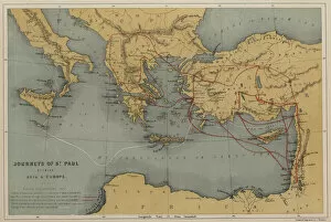
Background imageMaps Collection: Journeys of St Paul between Asia and Europe (colour litho)

Journeys of St Paul between Asia and Europe (colour litho)
3648396 Journeys of St Paul between Asia and Europe (colour litho) by English School, (19th century); Private Collection; (add.info.: Journeys of St Paul between Asia and Europe)

Background imageMaps Collection: Home and Colonial populations and areas, Comparative growth of foreign trade of chief commercial

Home and Colonial populations and areas, Comparative growth of foreign trade of chief commercial countries
3648958 Home and Colonial populations and areas, Comparative growth of foreign trade of chief commercial countries (colour litho) by English School

Background imageMaps Collection: British Colonies, exports and imports, Investment of British capital abroad (colour litho)

British Colonies, exports and imports, Investment of British capital abroad (colour litho)
3648956 British Colonies, exports and imports, Investment of British capital abroad (colour litho) by English School, (20th century); Private Collection; (add.info.: British Colonies)

Background imageMaps Collection: The worlds markets, Africa (colour litho)

The worlds markets, Africa (colour litho)
3648953 The worlds markets, Africa (colour litho) by English School, (20th century); Private Collection; (add.info.: The worlds markets, Africa)

Background imageMaps Collection: The worlds sources of supply, wool, cotton (colour litho)

The worlds sources of supply, wool, cotton (colour litho)
3648946 The worlds sources of supply, wool, cotton (colour litho) by English School, (20th century); Private Collection; (add.info.: The worlds sources of supply, wool, cotton)

Background imageMaps Collection: The world, telegraph, cable and time chart (colour litho)

The world, telegraph, cable and time chart (colour litho)
3648937 The world, telegraph, cable and time chart (colour litho) by English School, (20th century); Private Collection; (add.info.: The world, telegraph, cable and time chart)

Background imageMaps Collection: Lead (colour litho)

Lead (colour litho)
3648660 Lead (colour litho) by English School, (20th century); Private Collection; (add.info.: Lead. Illustration for Atlas of the Worlds Commerce compiled from the latest official returns at)

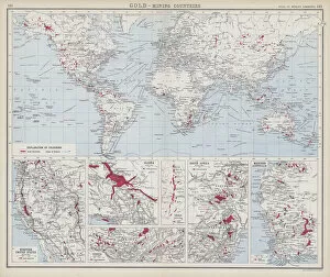
Background imageMaps Collection: Gold, mining countries (colour litho)

Gold, mining countries (colour litho)
3648659 Gold, mining countries (colour litho) by English School, (20th century); Private Collection; (add.info.: Gold, mining countries)

Background imageMaps Collection: Flax, hemp, jute etc (colour litho)

Flax, hemp, jute etc (colour litho)
3648641 Flax, hemp, jute etc (colour litho) by English School, (20th century); Private Collection; (add.info.: Flax, hemp, jute etc)

Background imageMaps Collection: Flax, hemp, jute etc (colour litho)

Flax, hemp, jute etc (colour litho)
3648638 Flax, hemp, jute etc (colour litho) by English School, (20th century); Private Collection; (add.info.: Flax, hemp, jute etc)

Background imageMaps Collection: Coffee (colour litho)

Coffee (colour litho)
3648615 Coffee (colour litho) by English School, (20th century); Private Collection; (add.info.: Coffee. Illustration for Atlas of the Worlds Commerce compiled from the latest official returns at)

Background imageMaps Collection: Coffee (colour litho)

Coffee (colour litho)
3648614 Coffee (colour litho) by English School, (20th century); Private Collection; (add.info.: Coffee. Illustration for Atlas of the Worlds Commerce compiled from the latest official returns at)


For sale as Licensed Images

Choose your image, Select your licence and Download the media

Maps have always been a fascinating window into the past, allowing us to explore and understand the world as it once was. From the intricate details of an ancient Greek map to the vibrant landscapes of Jamaica, each map tells its own unique story. Take a journey back in time with a Map of Ancient Greece, where you can trace the footsteps of philosophers and warriors alike. Discover the birthplace of democracy and marvel at the city-states that shaped Western civilization. Venture further across continents with Maps showcasing the vastness of empires like Britain's. Explore territories under British rule through a Map of the British Empire or delve into Asia's history with a Map highlighting the mighty Mongol Empire. Uncover remnants of one of history's greatest civilizations with a Map depicting the grandeur and reach of Rome. Witness how this powerful empire spanned across Europe, Africa, and Asia, leaving behind an indelible mark on human history. During times filled with turmoil and conflict, maps served as crucial tools for understanding war efforts. The Daily Mail War Map from World War I provides insights into battlefronts while WW2 posters display strategic plans like never before - including those detailing activities specific to divisions such as 52 (Lowland) Division or mapping out positions held by troops in The British Army. Closer to home lies Isle Of Wight - its beauty captured perfectly on a detailed map inviting exploration along its stunning coastline. Meanwhile, travel even further east to discover ancient Persian splendor through an intricately designed Persian Empire map. For those seeking nostalgia or tracing ancestral roots, immerse yourself in Cornwall C1857's historical charm via an antique map capturing its essence during that era. From ancient civilizations to modern-day conflicts and everything in between – they can not just pieces of paper but gateways into our collective pasts. They hold stories waiting to be unraveled by curious minds eager for knowledge about our ever-changing world throughout time.