
Nicolaes Jansz Visscher Collection
Nicolaes Jansz Visscher: Master Cartographer of the 17th Century Step into the world of Nicolaes Jansz Visscher


For sale as Licensed Images
Choose your image, Select your licence and Download the media
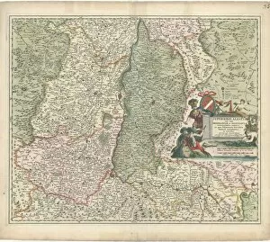
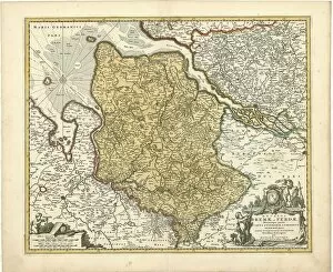
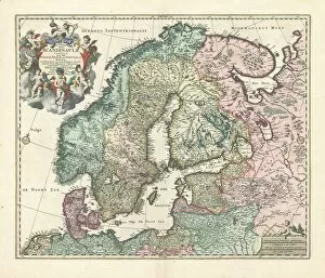
Nicolaes Jansz Visscher: Master Cartographer of the 17th Century Step into the world of Nicolaes Jansz Visscher, a renowned Dutch cartographer whose maps have stood the test of time. Known for his meticulous attention to detail and artistic flair, Visscher's works are a testament to his skill and passion for geography. One of his notable creations is the "Map Bavariae pars inferior cum insertis et adjacentibus regionibus n. " This map showcases the lower part of Bavaria, along with its surrounding regions. With intricate borders and precise labeling, it provides an invaluable resource for understanding this area during Visscher's era. Another masterpiece by Visscher is the "Map Ducatus Iuliacensis Cliviensis Montensis, " which depicts the Duchy of Julich in exquisite detail. From its cities to its rivers and mountains, every element on this map has been carefully crafted to provide an accurate representation. Visscher's expertise extends beyond Germany as seen in his work titled "Map Superioris Alsatiae nec non Brisigaviae et Suntgaviae geographic. " This map captures not only Upper Alsace but also highlights areas like Brisach and Sundgau. Its vibrant colors bring life to these territories while offering valuable geographical insights. The "Map Nova totius Westphaliae descriptio Nicolaes Jansz Visscher" showcases another facet of Visscher's talent. It presents a comprehensive overview of Westphalia, providing viewers with a glimpse into its towns, rivers, forests, and more. A true masterpiece that stands as a testament to his dedication. Visscher's contributions were not limited to Europe alone; he ventured further east with maps such as "Map MoscoviAŠ seu RussiAŠ magnAŠ generalis tabula quA Lapponia. " This map offers a detailed depiction of Russia, including Lapland.