mail_outline sales@mediastorehouse.com
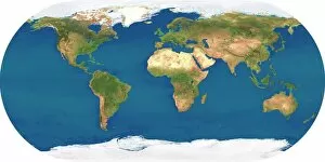
Whole Earth, satellite image. This map is centred on the Greenwich meridian, at zero degrees latitude. Arctic and Antarctic ice is white, oceans are blue and land is green and brown
Africa, satellite imageAfrica. Satellite image of the Earth centred on Africa. Clouds are white, oceans are blue and land is green and brown. Also seen are Europe (top) Asia (upper right), the Indian Ocean (right)
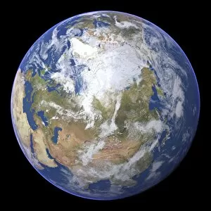
The Arctic, satellite imageThe Arctic. Satellite image of the Earth centred on the Arctic. The North Pole is at centre. Clouds and Arctic sea ice are white, oceans are blue and land is green and brown
Artic sea ice coverage, 1980 C014 / 4710Artic sea ice coverage, 1980. Map showing the changes in Arctic sea ice coverage from 1st November 1979 to 31st January 1980
Arabian Sea, satellite imageArabian Sea. Satellite image of the Earth centred on the Arabian Sea and western India. Clouds and Arctic ice (top) are white, oceans are blue and land is green and brown
The Americas, satellite imageThe Americas. Satellite image of the Earth centred on the Caribbean Islands, with North America at upper left and South America at bottom
Northern Asia and the Arctic. Satellite image of the Earth centred on Siberia, with the North Pole at upper centre. Clouds and Arctic sea ice are white, oceans are blue and land is green and brown
Choose your image, Select your licence and Download the media