
Pictorial Map Collection

Explore the fascinating world of pictorial maps through the ages

Background imagePictorial Map Collection: Tartariae sive Magni Chami Regni ty¨pus, 1603. Creators: Abraham Ortelius, Jan Baptist Vrients

Tartariae sive Magni Chami Regni ty¨pus, 1603. Creators: Abraham Ortelius, Jan Baptist Vrients
Tartariae sive Magni Chami Regni ty¨pus, 1603. Covers northern Asia. Relief shown pictorially. From Abraham Ortelius's atlas: Theatrvm Orbis Terrarvm, 1603 ed. Hand col

Background imagePictorial Map Collection: Touring map of the Custer Battlefield Hiway: the scenic route to the west, 1925. Creators: John C

Touring map of the Custer Battlefield Hiway: the scenic route to the west, 1925. Creators: John C. Mulford, C. C
Touring map of the Custer Battlefield Hiway: the scenic route to the west, 1925. The Custer Battlefield Highway was created in 1925 as a scenic route between Iowa and Montana

Background imagePictorial Map Collection: Carte de Tartarie, 1706. Creator: Guillaume Delisle

Carte de Tartarie, 1706. Creator: Guillaume Delisle
Carte de Tartarie, 1706

Background imagePictorial Map Collection: The Five-Year Plan of New Construction of Industry of the USSR: Map of the Asiatic Part

The Five-Year Plan of New Construction of Industry of the USSR: Map of the Asiatic Part... 1930 Creator: I. A
The Five-Year Plan of New Construction of Industry of the USSR: Map of the Asiatic Part of the USSR, 1930. Supplement to the map of the Five-Year plan of the European part of the USSR

Background imagePictorial Map Collection: The unique map of California, 1888. Creator: E. McD. Johnstone

The unique map of California, 1888. Creator: E. McD. Johnstone
The unique map of California, 1888. It was issued in 1888 by the Southern Pacific Railroad Company and the California State Board of Trade as part of a campaign to promote the economic, cultural

Background imagePictorial Map Collection: Russiae, Moskoviae et Tartariae descriptio, 1562. Creator: Anthony Jenkinson

Russiae, Moskoviae et Tartariae descriptio, 1562. Creator: Anthony Jenkinson
Russiae, Moskoviae et Tartariae descriptio, 1562. No. 1 Karta iz izdaniia: Atlas Aziatskoi Rossii.- SPb. Pereselencheskoe Upravlenie, kartogr. art. Zav. A.F. Marks, 1914

Background imagePictorial Map Collection: Vniversale descrittione di tvtta la terra conoscivta fin qvi, 1565

Vniversale descrittione di tvtta la terra conoscivta fin qvi, 1565. Creators: Paolo Forlani, Ferrando Bertelli
Vniversale descrittione di tvtta la terra conoscivta fin qvi, 1565. Relief shown pictorially. Based on an earlier map by Giacomo Gastaldi. From the Rosenwald Collection, Library of Congress, no

Background imagePictorial Map Collection: Pictorial Map of London (coloured engraving)

Pictorial Map of London (coloured engraving)
609385 Pictorial Map of London (coloured engraving) by English School, (19th century); Private Collection; (add.info.: Pictorial Map of London, published by the Geographers Map Co Ltd)


For sale as Licensed Images

Choose your image, Select your licence and Download the media

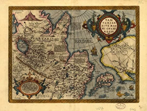
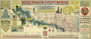
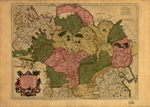
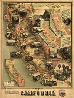
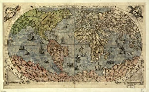
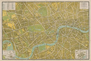
Explore the fascinating world of pictorial maps through the ages. From the intricately detailed "Tartariae sive Magni Chami Regni tyypeus" by Abraham Ortelius and Jan Baptist Vrients in 1603, to the scenic "Touring map of the Custer Battlefield Hiway" by John C. Mulford and C. C. Faunce in 1925. Discover the vast expanse of Tartary on Guillaume Delisle's "Carte de Tartarie" in 1706, or the industrial might of the USSR on I. A. Kalinnikov's "The Five-Year Plan of New Construction of Industry of the USSR: Map of the Asiatic Part.." in 1930. Delve into the unexplored territories of California with E. McD. Johnstone's "The unique map of California" in 1888, or Anthony Jenkinson's "Russiae, Moskoviae et Tartariae descriptio" in 1562. And let's not forget the vibrant and colorful depiction of London in the "Pictorial Map of London (coloured engraving)" - a visual feast for the eyes and mind." Or, if you prefer a more concise version: "Travel through time with these captivating pictorial maps. From Tartary in 1603 to California in 1888, and from Russia in 1562 to the USSR in 1930, these maps offer a unique perspective on history and geography." Or, for a more playful version: "Hop on a time machine and journey through the world of pictorial maps. From the intricately detailed maps of the past, like the 'Tartariae sive Magni Chami Regni tyypeus' by Abraham Ortelius and Jan Baptist Vrients in 1603, to the vibrant and colorful maps of the present, like the 'Pictorial Map of London (coloured engraving)', there's a map for every kind of traveler.