
River Don Collection

"Exploring the Rich History of River Don

Background imageRiver Don Collection: River Don, between Mexborough and Doncaster, 1803

River Don, between Mexborough and Doncaster, 1803
Full title: Plan of alterations and improvements to be made in the navigation of the River Dun [between Mexborough and Doncaster, Yorkshire, 1803 By W. and J. Fairbank. Scale 2 furlongs : 1 inch

Background imageRiver Don Collection: The Duke of Norfolks estates in Brightside Bierlow, Sheffield, [mid 19th cent]

The Duke of Norfolks estates in Brightside Bierlow, Sheffield, [mid 19th cent]
From an original at Sheffield Libraries: arc03909

Background imageRiver Don Collection: Ordnance Survey map of north east Sheffield copied by the Germans

Ordnance Survey map of north east Sheffield copied by the Germans, and marked with bombing targets, c. 1940
Original at Sheffield City Archives MD7731/4 and Sheffield Local Studies Librarys 26 M/5

Background imageRiver Don Collection: Plan of part of the townships of Sheffield and Nether Hallam, Sheffield, c. 1826

Plan of part of the townships of Sheffield and Nether Hallam, Sheffield, c. 1826
Full title: Plan of part of the townships of Sheffield and Nether Hallam which is in dispute. Includes John Addys house, Lidgate Field, Shales Moor Close, White House Lane or Walkley Road

Background imageRiver Don Collection: Map of Joseph Machens Farm at Wadsley Bridge, Sheffield, 1790

Map of Joseph Machens Farm at Wadsley Bridge, Sheffield, 1790
Full title: A map of Joseph Machens Farm at Wadsley Bridge held of the Duke of Norfolk with other intermediate lands Scale 4 chains : 1 inch [20 inches : 1 mile]. Surveyor: William Fairbank II

Background imageRiver Don Collection: Map of alterations and improvements intended to be made in the navigation of the River Dun, 1820

Map of alterations and improvements intended to be made in the navigation of the River Dun, 1820
By W. and J. Fairbank. Show present course of the river (blue) and proposed cuts and diversion (red). Left to right: Wheatley, Bentley cum Arksey, Copleys Close, West Ratch, wear [weir]

Background imageRiver Don Collection: Plan of Sandbed Wheel held of the Earl of Surrey by the assignees of Thomas Broadbent, Neepsend

Plan of Sandbed Wheel held of the Earl of Surrey by the assignees of Thomas Broadbent, Neepsend, Sheffield, 1783
Scale: 2 chains : 1 inch [40 inches : 1 mile] Surveyor: William Fairbank II. Wheels, dam and goit clearly shown and named; numerical list with descriptions and acreages; height of fall given

Background imageRiver Don Collection: Valley of the River Don, Sheffield, 1856

Valley of the River Don, Sheffield, 1856
Note: the original item is over 170 years old and has had some minor (but visible) repair work on it over the years. Published September 20th 1856 by Wm. Ibbitt, 152 Broad Lane, Sheffield

Background imageRiver Don Collection: A map of the land belonging to Wortley Forges, 1746

A map of the land belonging to Wortley Forges, 1746
Marked: Three Acres, Two Acres, the High Road, Staniland Holme, Smithy Mires, River Dun [River Don], garden, Five Acres, Dusting Close, Back Meadows, Shop Croft, Nether Forge

Background imageRiver Don Collection: Map and diagram of the world, folio a4v of Orbis Breviarium by Zaccaria Lilio (d. c)

Map and diagram of the world, folio a4v of Orbis Breviarium by Zaccaria Lilio (d. c)
488665 Map and diagram of the world, folio a4v of Orbis Breviarium by Zaccaria Lilio (d.c.1522), Florence, 1493 (print & woodcut) by Italian School

Background imageRiver Don Collection: View from the Terrace, Richmond Hill (oil on canvas)

View from the Terrace, Richmond Hill (oil on canvas)
CH142239 View from the Terrace, Richmond Hill (oil on canvas) by Barrett, G. (1767-1842) and Gilpin, S. (1703-1807); 96.5x137.2 cm; Private Collection; Photo eChristies Images; English

Background imageRiver Don Collection: The Big Chimney, Sheffield, 1910 (etching)

The Big Chimney, Sheffield, 1910 (etching)
SAG115183 The Big Chimney, Sheffield, 1910 (etching) by Pennell, Joseph (1858-1926); 31.5x24 cm; Sheffield Galleries and Museums Trust

Background imageRiver Don Collection: A Picturesque Map of the Seat of War, in the Danubian Provinces, Turkey, Asia Minor, Southern Russia

A Picturesque Map of the Seat of War, in the Danubian Provinces, Turkey, Asia Minor, Southern Russia
1607993 A Picturesque Map of the Seat of War, in the Danubian Provinces, Turkey, Asia Minor, Southern Russia, and the Crimea (engraving) by English School

Background imageRiver Don Collection: Early Morning on the Don, Sheffield (colour litho)

Early Morning on the Don, Sheffield (colour litho)
980955 Early Morning on the Don, Sheffield (colour litho) by English School, (20th century); Private Collection; (add.info.: Early Morning on the Don, Sheffield.); Look and Learn / Elgar Collection

Background imageRiver Don Collection: Wedding couple crossing the river Don, Mexborough, South Yorkshire, 1961. Artist

Wedding couple crossing the river Don, Mexborough, South Yorkshire, 1961. Artist
Wedding couple crossing the river Don, Mexborough, South Yorkshire, 1961. Photographer Michael Walters with his new bride Patricia wave after they crossed the river Don on a rope pulled ferry boat

Background imageRiver Don Collection: Ferry boat wedding party, Mexborough, South Yorkshire, 1960. Artist: Michael Walters

Ferry boat wedding party, Mexborough, South Yorkshire, 1960. Artist: Michael Walters
Ferry boat wedding party, Mexborough, South Yorkshire, 1960. A wedding party crosses the River Don on a trditional rope pulled barge

Background imageRiver Don Collection: Aberdeen - General View from the River, 1895

Aberdeen - General View from the River, 1895. From Round the Coast. [George Newnes Limited, London, 1895]

Background imageRiver Don Collection: View of Sheffield, c. 1720-1740

View of Sheffield, c. 1720-1740
Full title: To the Worshipful the Master, Wardens, Searchers and Assistants of the Corporation of the Cutlers in Hallamshire in the County of York

Background imageRiver Don Collection: River Don from Ladys Bridge, Sheffield, c. 1900

River Don from Ladys Bridge, Sheffield, c. 1900
From an original at Sheffield Libraries: w00344

Background imageRiver Don Collection: 3D Aberdeen city, 1988

3D Aberdeen city, 1988
Old Aberdeen, Aberdeen, ABERDEENSHIRE, SCOTLAND. NCAP: Scottish Office: All Scotland Survey - 11/09/1988

Background imageRiver Don Collection: View of city centre river and buildings, River Don, Sheffield, South Yorkshire, England, april

View of city centre river and buildings, River Don, Sheffield, South Yorkshire, England, april

Background imageRiver Don Collection: View of city centre river with bridges, River Don, Sheffield, South Yorkshire, England, april

View of city centre river with bridges, River Don, Sheffield, South Yorkshire, England, april


For sale as Licensed Images

Choose your image, Select your licence and Download the media

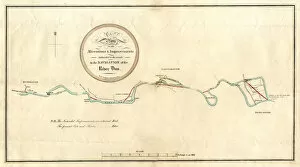
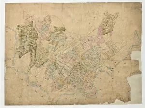
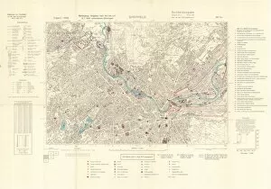
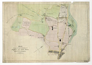
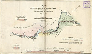
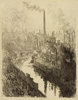
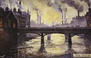
"Exploring the Rich History of River Don: From 18th Century Sheffield to Bombing Targets in World War II" Step back in time and immerse yourself in the captivating story of River Don, as it winds its way between Mexborough and Doncaster since 1803. This river has witnessed significant historical events that have shaped the region's landscape and culture. Intriguingly, during World War II, German forces meticulously studied an Ordnance Survey map of north-east Sheffield, marking it with bombing targets. This chilling artifact serves as a reminder of the city's resilience amidst adversity. Delve further into history with a plan from 1826 showcasing part of the townships of Sheffield and Nether Hallam. It offers a glimpse into how this area evolved over time, reflecting changes in society and urban development. Travel even further back to Joseph Machens Farm at Wadsley Bridge in 1790 through an ancient map. Witness how agriculture played a vital role along River Don centuries ago, sustaining communities and shaping their way of life. A breathtaking view captured on canvas transports us to Sheffield circa 1720-1740. The bustling cityscape reveals glimpses into daily life along River Don during this era—a testament to its importance as a hub for trade and industry. Fast forward to c. 1900 when Ladys Bridge provided an enchanting vantage point overlooking River Don—an idyllic scene frozen in time. Imagine strolling along its banks, feeling connected to nature while surrounded by the heartbeat of industrial progress. The Duke of Norfolk's estates stand tall within Brightside Bierlow during the mid-19th century—an emblematic symbol representing power intertwined with local heritage along River Don. Discover Sandbed Wheel held by Thomas Broadbent's assignees under Earl Surrey's ownership through a detailed plan from Neepsend dating back to 1783—unearthing forgotten stories etched into the river's history.