
Salt River Collection
The Salt River in Arizona: A Historic Journey through Irrigation, War, and Floods (NATI2D-00366) From the pages of history


For sale as Licensed Images
Choose your image, Select your licence and Download the media
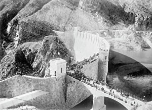
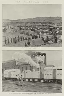
The Salt River in Arizona: A Historic Journey through Irrigation, War, and Floods (NATI2D-00366) From the pages of history, the Salt River in Arizona tells a captivating story. Witness the Cape Railway (engraving) as it traverses the landscape, a testament to early transportation. The Transvaal War (litho) brought conflict to the valley, but post-war, the focus shifted to irrigation. Explore Tempe, Arizona, through a US City Street Map, where the Salt River's waters nourished crops like alfalfa in Chandler (Baling alfalfa Salt River Valley Chandler Ariz). The Mormon Flat Dam, built in 1938 (MORMON FLAT DAM, 1938. The Mormon Flat Dam on the Salt River in Arizona. Photograph by Ben Glaha), harnessed the river's power, transforming the desert. Apache men labored on the irrigation project (ARIZONA: APACHE MEN. Apache men at work on the Salt River irrigation project in Arizona), while the river provided essential resources for the community. However, the Salt River's power was not always tamed. In 1891, devastating floods struck, as seen in the images of men observing the damage from the shore (ARIZONA: FLOOD, 1891. Men observing the damage from the shore of the Salt River in Phoenix) and seated on the wreckage of a railroad bridge (ARIZONA: FLOOD, 1891. Men seated on the wreckage of a railroad bridge on the Salt River). Through it all, the Salt River remains an integral part of Arizona's history and identity.