Home > Animals > Farm > Cattle > Related Images
Ground Plan of New Road from Islington to Edgware Road, 1755, (c1876). Creator: Unknown
. Creator: Unknown")
![]()
Wall Art and Photo Gifts from Heritage Images
Ground Plan of New Road from Islington to Edgware Road, 1755, (c1876). Creator: Unknown
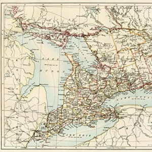
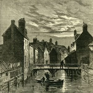
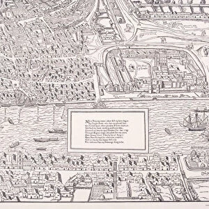
Ground Plan of New Road from Islington to Edgware Road, 1755, (c1876). The New Road from Paddington to Islington opened in 1756 as Londons first bypass along which to drive cattle to Smithfield Market avoiding central London. From " Old and New London: A Narrative of Its History, Its People, and Its Places. The Western and Northern Studies", by Edward Walford. [Cassell, Petter, Galpin & Co. London, Paris & New York]
Heritage Images features heritage image collections
Media ID 19125024
© The Print Collector/Heritage Images
Cassell Petter Galpin Cassell Petter Galpin Co Co Cassell Petter Galpin Edgware Road Edward Edward Walford Euston Road Floor Plan Galpin And Co Georgian Ground Plan Islington Islington London England London England United Kingdom North London Old And New London Oxford Street Paddington Petter Petter And Galpin Plan Planning Roadworks Route Urbanisation Walford Walford Edward Bypass Cassell City Of Westminster New Road Road Map
FEATURES IN THESE COLLECTIONS
> Animals
> Farm
> Cattle
> Related Images
> Animals
> Mammals
> Bovidae
> Cattle
> Arts
> Artists
> D
> Edward Dayes
> Arts
> Minimalist artwork
> Monochrome artwork
> Fine art
> Arts
> Minimalist artwork
> Monochrome artwork
> Monochrome paintings
> Asia
> Georgia
> Related Images
> Europe
> France
> Paris
> Maps
> Europe
> United Kingdom
> England
> London
> Boroughs
> City of Westminster
> Europe
> United Kingdom
> England
> London
> Boroughs
> Islington
EDITORS COMMENTS
This print captures the historical significance of the "Ground Plan of New Road from Islington to Edgware Road" dating back to 1755. Created by an unknown artist, this image showcases London's first bypass, which opened in 1756 as a route for driving cattle to Smithfield Market while avoiding central London. The photograph is taken from "Old and New London: A Narrative of Its History, Its People, and Its Places" written by Edward Walford. Published in the late 19th century by Cassell, Petter, Galpin & Co. , this antique print offers a glimpse into the city's past. The ground plan depicted here reveals the layout of this historic road that connected Paddington to Islington. It highlights key landmarks such as Euston Road and Oxford Street while showcasing its importance as a transportation route during the Georgian era. With intricate details captured through engraving techniques, this monochrome image evokes a sense of nostalgia for England's rich history. The print serves as both a visual representation and documentation of urban planning in 18th-century Britain. As we gaze upon this piece, we are transported back in time to witness how roads were meticulously planned amidst bustling city life. This photograph is not only an artistic creation but also an invaluable historical artifact that sheds light on London's development and transformation over centuries.
MADE IN THE USA
Safe Shipping with 30 Day Money Back Guarantee
FREE PERSONALISATION*
We are proud to offer a range of customisation features including Personalised Captions, Color Filters and Picture Zoom Tools
SECURE PAYMENTS
We happily accept a wide range of payment options so you can pay for the things you need in the way that is most convenient for you
* Options may vary by product and licensing agreement. Zoomed Pictures can be adjusted in the Cart.