Home > Europe > France > Paris > Maps
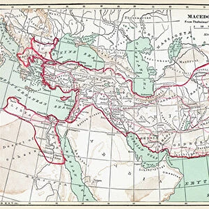
'Le Front D'Orient, de L'Adriatique a L'Egee; Le developpement des operations... 1918. Creator: Unknown

![]()
Wall Art and Photo Gifts from Heritage Images
'Le Front D'Orient, de L'Adriatique a L'Egee; Le developpement des operations... 1918. Creator: Unknown
'Le Front D'Orient, de L'Adriatique a L'Egee; Le developpement des operations, de Septembre 1916 A Octobre 1918, 1918. From "L'Album de la Guerre 1914-1919, Volume 2" [L'Illustration, Paris, 1924]
Heritage Images features heritage image collections
Media ID 36340953
© The Print Collector/Heritage Images
Balkan Campaign Campaign Conflict Eastern Front Lillustration Macedonian Front Military Campaign Salonika Front
FEATURES IN THESE COLLECTIONS
> Europe
> France
> Paris
> Maps
> Europe
> Macedonia
> Posters
> Europe
> Macedonia
> Related Images
> Historic
> World War I and II
> World War I
> Historic
> World War I and II
> Maps and Charts
> North Macedonia
EDITORS COMMENTS
Le Front D'Orient, de L'Adriatique à L'Egée; Le développement des opérations, de Septembre 1816 A Octobre 1918" is a historic black and white print depicting the Eastern Front of the First World War, specifically the campaigns from the Adriatic Sea to the Aegean Sea, between September 1916 and October 1918. The creator of this print is unknown, but it was published in "L'Album de la Guerre 1914-1919, Volume 2" by L'Illustration, a renowned French publication based in Paris, in 1924. The image showcases a detailed map of the Eastern Front during the latter stages of the war, highlighting the key locations of military engagements. The map stretches from the Adriatic Sea in the west to the Aegean Sea in the east, encompassing the Balkan Peninsula and the areas surrounding Salonika, Macedonia, and Constantinople. The map is adorned with annotations, indicating the progression of military operations, including the Battle of the Somme, the Battle of Verdun, and the Battle of Caporetto, among others. The print serves as a testament to the complexities and intricacies of the Eastern Front during the First World War, which saw intense fighting between the Central Powers, primarily Austria-Hungary and Bulgaria, and the Allied Powers, consisting of France, Great Britain, and Russia, among others. The map also illustrates the strategic importance of the Balkan Peninsula and the Mediterranean Sea during this period, as well as the significant role played by various military forces in shaping the course of the war. This historic print is an essential addition to any collection of First World War memorabilia, military history, or cartography. It offers a unique perspective on the Eastern Front, providing valuable insights into the geography, military strategies, and historical context of one of the most significant conflicts in human history.
MADE IN THE USA
Safe Shipping with 30 Day Money Back Guarantee
FREE PERSONALISATION*
We are proud to offer a range of customisation features including Personalised Captions, Color Filters and Picture Zoom Tools
SECURE PAYMENTS
We happily accept a wide range of payment options so you can pay for the things you need in the way that is most convenient for you
* Options may vary by product and licensing agreement. Zoomed Pictures can be adjusted in the Cart.