Home > Europe > Netherlands > Utrecht
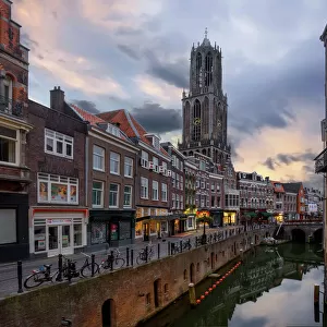
Map of Holland, Utrecht and part of Gelderland, 1726-1727. Creator: Caspar Specht

![]()
Wall Art and Photo Gifts from Heritage Images
Map of Holland, Utrecht and part of Gelderland, 1726-1727. Creator: Caspar Specht
Map of Holland, Utrecht and part of Gelderland, 1726-1727. Map of the county of Holland, the seigneury of Utrecht and most of the Duchy of Gelderland. Texel and Vlieland in the top left. Below that the Dutch title. At the top right two scales: German and French miles. Possibly by Caspar Specht
Heritage Images features heritage image collections
Media ID 36338593
© Heritage Art/Heritage Images
Island Islands North Sea Zuider Zee Zuiderzee Zuyder Zee Watercolour Paint
FEATURES IN THESE COLLECTIONS
> Europe
> Netherlands
> Maps
> Europe
> Netherlands
> Posters
> Europe
> Netherlands
> Related Images
> Europe
> Netherlands
> Utrecht
> Maps and Charts
> Netherlands
EDITORS COMMENTS
This exquisite map print, created by Caspar Specht between 1726 and 1727, showcases a detailed representation of the counties of Holland, Utrecht, and most of Gelderland in the Netherlands. The map is centered on the North Sea, with the islands of Texel and Vlieland prominently displayed in the top left corner. The Dutch title is inscribed at the top right, accompanied by two scales for German and French miles. Caspar Specht's masterful use of ink and watercolor paint brings the geographical features of this region to life. The intricate depiction of the coastline, islands, and waterways reveals the rich maritime heritage of the Low Countries. The map's vibrant colors and meticulous attention to detail transport us back to the 18th century, offering a glimpse into the past and the cartographic knowledge of the time. The Rijksmuseum in Amsterdam, a renowned museum for art and heritage, houses this precious map print. It serves as an essential addition to their extensive collection of European art and cartography from the 18th century. The map's historical significance and artistic merit make it a valuable resource for researchers, historians, and anyone interested in the geography and history of the Netherlands and the surrounding North Sea. As we explore the intricacies of Caspar Specht's Map of Holland, Utrecht, and part of Gelderland, we are reminded of the importance of preserving our cultural heritage and the role that maps play in documenting our world's history.
MADE IN THE USA
Safe Shipping with 30 Day Money Back Guarantee
FREE PERSONALISATION*
We are proud to offer a range of customisation features including Personalised Captions, Color Filters and Picture Zoom Tools
SECURE PAYMENTS
We happily accept a wide range of payment options so you can pay for the things you need in the way that is most convenient for you
* Options may vary by product and licensing agreement. Zoomed Pictures can be adjusted in the Cart.