Home > Asia > Israel > Maps
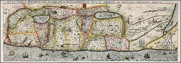
Map of the Holy Land Divided into the Twelve Tribes of Israel, 1580s. Creator: Adrichem, Christian Kruik van (1533-1585)
![]()

Wall Art and Photo Gifts from Heritage Images
Map of the Holy Land Divided into the Twelve Tribes of Israel, 1580s. Creator: Adrichem, Christian Kruik van (1533-1585)
Map of the Holy Land Divided into the Twelve Tribes of Israel, 1580s. Private Collection
Heritage Images features heritage image collections
Media ID 36250989
© Fine Art Images/Heritage Images
Cartography Copper Engraving Watercolour Israel Judaism Tanach Tanakh The Netherlands Twelve Tribes Of Israel
FEATURES IN THESE COLLECTIONS
> Asia
> Israel
> Related Images
> Europe
> Netherlands
> Maps
> Europe
> Netherlands
> Posters
> Europe
> Netherlands
> Related Images
> Maps and Charts
> Netherlands
EDITORS COMMENTS
This exquisite map, titled "Map of the Holy Land Divided into the Twelve Tribes of Israel," dates back to the late 16th century and was created by the renowned Flemish cartographer, Christian Kruik van Adrichem. Born in Antwerp, Belgium, in 1533, Adrichem was a prolific mapmaker, engraver, and publisher who is best known for his detailed and accurate cartographic works, particularly those related to the Holy Land and the Bible. The map depicts the land of Israel as it was traditionally believed to have been divided among the Twelve Tribes of Israel according to the Old Testament. The map is a beautiful example of the intricate cartographic techniques of the time, with meticulous attention paid to topographical features, geographical details, and biblical references. The map is a copper engraving, with delicate watercolor additions, adding to its visual appeal and historical significance. The map is rich in symbolism and biblical references. Each tribe is represented by a distinct symbol, such as a bull for the tribe of Dan or a grape cluster for Ephraim. The map also includes various biblical sites, such as Jerusalem, Bethlehem, and the Dead Sea. The map's border is adorned with intricate decorative elements, including cherubs, angels, and other biblical motifs. The map is a testament to the deep religious and historical significance of the land of Israel in the late 16th century, and it reflects the meticulous cartographic techniques and artistic skills of the time. This map is a valuable addition to any collection of historical maps, biblical studies, or cartography, and it continues to fascinate scholars, historians, and collectors alike.
MADE IN THE USA
Safe Shipping with 30 Day Money Back Guarantee
FREE PERSONALISATION*
We are proud to offer a range of customisation features including Personalised Captions, Color Filters and Picture Zoom Tools
SECURE PAYMENTS
We happily accept a wide range of payment options so you can pay for the things you need in the way that is most convenient for you
* Options may vary by product and licensing agreement. Zoomed Pictures can be adjusted in the Cart.


