Home > Animals > Mammals > Cats (Domestic) > Russian White
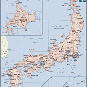
Map of the Kuril Islands with Surrounding Areas, 1700-1799. Creator: Unknown

![]()
Wall Art and Photo Gifts from Heritage Images
Map of the Kuril Islands with Surrounding Areas, 1700-1799. Creator: Unknown
Map of the Kuril Islands with Surrounding Areas, 1700-1799. This 18th century Russian map depicts the Kurile Islands archipelago, located on the far eastern edge of the Russian Empire. Although inaccurate in places, the map attempts to show the large and small islands throughout the entire chain. Most of the Kurile Islands are listed by name, a geographical specificity quite unusual for such a remote region in this era. As with the nearby Aleutian Islands, by this time these islands had been repeatedly visited by both Russian maritime explorers and hunters of sea otter. Sakhalin Island is also seen toward the upper center of the map, alongside the Russian mainland, as is the Kamchatka Peninsula toward the upper right. Some rivers, lakes, and other bodies of water are listed by name. Relief is indicated pictorially in places. Northern Japan, principally Hokkaido, is shown toward the lower left of the map. Geographic coordinates for longitude on this map are measured from Ferro (present-day Hierro), the westernmost of the Canary Islands (the western edge of the world known to the ancients), used by geographers back to the time of Ptolemy as a base point prior to the agreement in 1884 that the prime meridian would run through Greenwich, England
Heritage Images features heritage image collections
Media ID 35130817
© Heritage Art/Heritage Images
Aleutian Islands Archipelago Cartographic Cartography Cyrillic Headland Kamchatka Peninsula Mainland Map Making Mapmaking Marine Maritime Peninsula Russian Empire Russian Federation Russian State Library Sakhalin Sakhalinskaya Oblast Russia Hokkaido Kuril Islands Meeting Of Frontiers
FEATURES IN THESE COLLECTIONS
> Animals
> Mammals
> Cats (Domestic)
> Russian White
> Animals
> Mammals
> Muridae
> Water Mouse
> Animals
> Mammals
> Muridae
> Western Mouse
> Animals
> Mammals
> Mustelidae
> Marine Otter
> Animals
> Mammals
> Mustelidae
> Sea Otter
> Animals
> Mammals
> Sea Otter
> Arts
> Landscape paintings
> Waterfall and river artworks
> River artworks
> Asia
> Japan
> Lakes
> Related Images
> Asia
> Japan
> Related Images
EDITORS COMMENTS
This 18th century map, titled "Map of the Kuril Islands with Surrounding Areas, 1700-1799," is an intriguing glimpse into the early cartographic exploration of the remote Kurile Islands archipelago, located on the eastern edge of the Russian Empire. The map, of unknown origin, shows the Kurile Islands and the surrounding areas with a level of detail unusual for such a distant region during this era. The map includes most of the Kurile Islands, with many named, indicating the frequent visits by Russian maritime explorers and sea otter hunters. Sakhalin Island is also depicted toward the upper center, alongside the Russian mainland, and the Kamchatka Peninsula is shown toward the upper right. Some rivers, lakes, and other bodies of water are labeled, and relief is indicated pictorially in places. Northern Japan, specifically Hokkaido, is shown toward the lower left of the map. Longitude on this map is measured from Ferro, the westernmost of the Canary Islands, which was used as a base point prior to the agreement in 1884 that the prime meridian would run through Greenwich, England. Despite its inaccuracies in places, this map represents an important historical record of early European knowledge of the Kurile Islands and the surrounding regions. Its inclusion of many named features and geographical specificity underscores the growing interest and exploration of the Pacific Rim during the late 1700s.
MADE IN THE USA
Safe Shipping with 30 Day Money Back Guarantee
FREE PERSONALISATION*
We are proud to offer a range of customisation features including Personalised Captions, Color Filters and Picture Zoom Tools
SECURE PAYMENTS
We happily accept a wide range of payment options so you can pay for the things you need in the way that is most convenient for you
* Options may vary by product and licensing agreement. Zoomed Pictures can be adjusted in the Cart.