Home > Arts > Literature
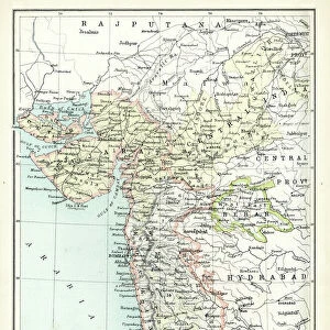
Map of Presidency of Bombay, c1891. Creator: James Grant

![]()
Wall Art and Photo Gifts from Heritage Images
Map of Presidency of Bombay, c1891. Creator: James Grant
Map of Presidency of Bombay, c1891. From " Cassells Illustrated History of India Vol. I.", by James Grant. [Cassell Petter & Galpin, London, Paris and New York]
Heritage Images features heritage image collections
Media ID 25322295
© The Print Collector/Heritage Images
Bombay Maharashtra India British India British Raj Cassell Petter Galpin Cassells Illustrated History Of India Galpin Grant James Imperialism India Asia James Grant Mumbai Maharashtra India Petter And Petter And Galpin The Raj Bombay Presidency British Empire Cassell Hindoostan
FEATURES IN THESE COLLECTIONS
> Arts
> Literature
> Illustration
> Arts
> Literature
> Asia
> India
> Related Images
> Asia
> Related Images
> Europe
> France
> Paris
> Maps
> Historic
> Colonial history
> Colonial art and artists
> Maps and Charts
> British Empire Maps
EDITORS COMMENTS
This print showcases a remarkable piece of history - the "Map of Presidency of Bombay, c1891" created by James Grant. Taken from his renowned work "Cassells Illustrated History of India Vol. I. ", this map offers a fascinating glimpse into the British Raj era. The intricate details and precision with which Grant has depicted the boundaries and landmarks of Bombay Presidency are truly commendable. Every inch of this map tells a story, narrating the colonial legacy that shaped not only Bombay but also the entire Indian subcontinent. As we closely examine this close-up view, we can't help but appreciate how it captures both the grandeur and complexity of British India. The vastness of the empire is evident as we trace our eyes across its borders, stretching from Mumbai in Maharashtra to various regions within Hindoostan. Grant's masterpiece serves as an invaluable resource for scholars and enthusiasts alike, shedding light on a crucial period in Indian history marked by imperialism and colonialism. It transports us back to a time when maps were more than just geographical representations; they were tools used to assert dominance over lands far away from home. This print is not just an artistic creation but also a testament to human curiosity about distant lands and cultures. It reminds us that even in today's interconnected world, there is still much to learn from our pasts - both glorious and controversial.
MADE IN THE USA
Safe Shipping with 30 Day Money Back Guarantee
FREE PERSONALISATION*
We are proud to offer a range of customisation features including Personalised Captions, Color Filters and Picture Zoom Tools
SECURE PAYMENTS
We happily accept a wide range of payment options so you can pay for the things you need in the way that is most convenient for you
* Options may vary by product and licensing agreement. Zoomed Pictures can be adjusted in the Cart.