Home > Animals > Insects > Hemiptera > Rose Scale
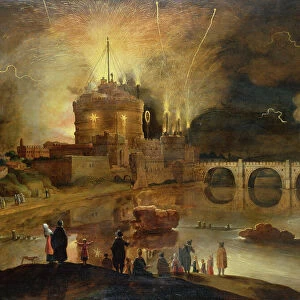
Map of Rosendael Castle, c.1650-before 1722. Creator: Anon

![]()
Wall Art and Photo Gifts from Heritage Images
Map of Rosendael Castle, c.1650-before 1722. Creator: Anon
Map of Rosendael Castle, c.1650-before 1722. Map of the castle and the gardens. Bottom left a compass with a scale: Rijnlande rods
Heritage Images features heritage image collections
Media ID 36330429
© Heritage Art/Heritage Images
Aerial View Birds Eye View Compass Direction Estate Grounds Measurement Measurements Moat North Northern Scale Scale Drawing Compass Rose Fortifications Watercolour Paint
FEATURES IN THESE COLLECTIONS
> Aerial Photography
> Netherlands
> Aerial Photography
> Related Images
> Animals
> Insects
> Hemiptera
> Rose Scale
> Animals
> Insects
> Spiders
> European Garden
> Europe
> Netherlands
> Aerial Views
> Europe
> Netherlands
> Castles
> Europe
> Netherlands
> Maps
> Europe
> Netherlands
> Posters
> Europe
> Netherlands
> Related Images
> Historic
> Medieval architecture
> Castles and fortresses
> Ancient fortifications
EDITORS COMMENTS
This map print, titled "Map of Rosendael Castle," dates back to the 17th century, with possible revisions extending into the early 18th century. The intricately detailed drawing showcases the grandiose Rosendael Castle and its surrounding gardens, offering an aerial view that transports us back in time. The map is rendered in ink and watercolor, with a compass and scale at the bottom left corner, marked as "Rijnlande rods." Rosendael Castle, located in the Netherlands, was a significant fortification in the Low Countries during the late medieval and early modern periods. This map provides a comprehensive view of the castle's layout, including its moat, various buildings, and gardens. The inclusion of the compass rose indicates the map's orientation, with magnetic north pointed towards the top. The meticulous attention to detail in this map is a testament to the artistic and cartographic skills of the anonymous artist. The map's historical significance lies in its ability to provide valuable insights into the architectural and horticultural aspects of Rosendael Castle during this period. Today, this map serves as an essential piece of heritage art, offering a glimpse into the rich history of the Netherlands and its architectural heritage. The map's age and artistic merit make it an invaluable addition to any collection focused on European history, art, or cartography. Its intricate details and historical significance make it a fascinating conversation starter and a beautiful decorative piece. This map is not only a historical document but also a work of art that can be appreciated for its aesthetic qualities.
MADE IN THE USA
Safe Shipping with 30 Day Money Back Guarantee
FREE PERSONALISATION*
We are proud to offer a range of customisation features including Personalised Captions, Color Filters and Picture Zoom Tools
SECURE PAYMENTS
We happily accept a wide range of payment options so you can pay for the things you need in the way that is most convenient for you
* Options may vary by product and licensing agreement. Zoomed Pictures can be adjusted in the Cart.