Home > Europe > France > Canton > Moselle
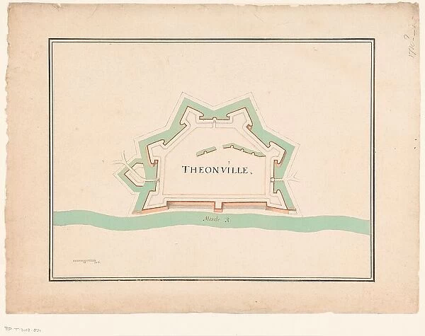
Map of Thionville, c.1710. Creator: Anon
![]()

Wall Art and Photo Gifts from Heritage Images
Map of Thionville, c.1710. Creator: Anon
Map of Thionville, c.1710. Map of the Fortress of Thionville (here spelled Theonville) on the Moselle. A scale at the bottom left
Heritage Images features heritage image collections
Media ID 36330219
© Heritage Art/Heritage Images
City Walls Fortress Measurement Measurements Mosel Moselle River Mosel Scale Scale Drawing Town Wall Walled City Walled Town Watercolour Paint
FEATURES IN THESE COLLECTIONS
> Arts
> Landscape paintings
> Waterfall and river artworks
> River artworks
> Europe
> France
> Canton
> Moselle
> Europe
> Netherlands
> Maps
> Europe
> Netherlands
> Posters
> Europe
> Netherlands
> Related Images
> Europe
> Netherlands
> Rivers
> Maps and Charts
> Early Maps
EDITORS COMMENTS
This exquisite map print, titled "Map of Thionville," dates back to the early 18th century, around 1710. Anonymous in origin, this beautiful work of art showcases the fortified town of Thionville, now known as Theonville, situated on the picturesque Moselle River in present-day Grand Est, France, Europe. The intricate detailing of the map reveals the town's defensive structures, including its city walls and fortress, which protected it from potential invaders. The map is rendered in ink on paper, with subtle watercolor accents adding depth and texture to the geographical features. The scale at the bottom left indicates the measurement of 1 tole (a French unit of length) equaling 76.2 feet, providing a sense of the map's accuracy and meticulousness. Thionville, an essential trading hub during the Dutch and Eighteenth Century, is depicted with a clear layout of its streets and buildings, making it an invaluable historical document. The map's vibrant colors and intricate details offer a glimpse into the past, providing a fascinating insight into the architectural and geographical features of this walled town during that era. This map is a precious addition to any collection of European heritage art, history, or geography. It is a testament to the artistic and cartographic skills of the anonymous artist, whose work continues to captivate and inspire scholars and enthusiasts alike. The map is currently housed in the esteemed Rijksmuseum in the Netherlands, where it is preserved for future generations to appreciate and learn from.
MADE IN THE USA
Safe Shipping with 30 Day Money Back Guarantee
FREE PERSONALISATION*
We are proud to offer a range of customisation features including Personalised Captions, Color Filters and Picture Zoom Tools
SECURE PAYMENTS
We happily accept a wide range of payment options so you can pay for the things you need in the way that is most convenient for you
* Options may vary by product and licensing agreement. Zoomed Pictures can be adjusted in the Cart.

