Home > Europe > United Kingdom > England > London > Sights > New River
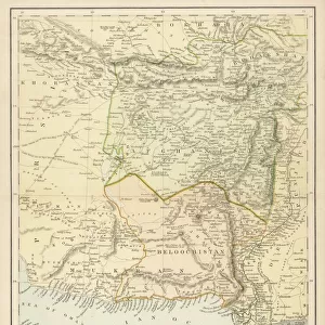
Map of the Tirah Campaign, c1900. Creator: Unknown

![]()
Wall Art and Photo Gifts from Heritage Images
Map of the Tirah Campaign, c1900. Creator: Unknown
Map of the Tirah Campaign, c1900. The Tirah expedition was an Indian frontier campaign from September 1897 to April 1898. Tirah is a mountainous tract of country in what was formally known as Federally Administered Tribal Areas of Pakistan, now Khyber Pakhtunkhwa province. Map showing towns and cities, rivers, forts, mountains and mountain passes, including the Afghan frontier, Surghar Range, Kuram River, Bazar Valley, Bara and Mastura Valleys. From "Cassell's History of England, Vol. IX". [Cassell and Company, Limited, London, Paris, New York & Melbourne]
Heritage Images features heritage image collections
Media ID 36338738
© The Print Collector/Heritage Images
Afghan War Afghanistan Border Borders Cassell And Co Cassell Co Cassell Company Cassells Cassells History Of England Co Cassell Frontier Frontiers Imperialism Mountainous Pakistan Rivers British Empire Cassell And Company Ltd Hindoostan
FEATURES IN THESE COLLECTIONS
> Asia
> Afghanistan
> Maps
> Asia
> Pakistan
> Related Images
> Europe
> France
> Paris
> Maps
> Europe
> United Kingdom
> England
> London
> Sights
> New River
> Europe
> United Kingdom
> England
> Maps
> Europe
> United Kingdom
> England
> Rivers
> Europe
> United Kingdom
> England
> York
> Maps and Charts
> British Empire Maps
EDITORS COMMENTS
This black and white print depicts the 'Map of the Tirah Campaign' from the late 19th century, specifically from around 1900. The Tirah expedition was a significant military campaign in the Indian frontier region, taking place from September 1897 to April 1898. The campaign was conducted in the Tirah area, which is a mountainous region located in what is now known as Khyber Pakhtunkhwa province in Pakistan. The map itself is a detailed representation of the area, highlighting various towns and cities, rivers, forts, mountains, and mountain passes. Notable features include the Afghan frontier, Surghar Range, Kuram River, Bazar Valley, and the Bara and Mastura Valleys. The map serves as an intriguing snapshot of the geography and borders of the region during a time of imperial expansion and conflict. This print was originally published in 'Cassell's History of England, Vol. IX' by Cassell and Company, Limited, a renowned publishing house based in London, Paris, New York, and Melbourne. The map provides a fascinating glimpse into the geopolitical landscape of the region during the British Empire's rule in India, or Hindoostan, as it was then known. The map's intricate details and historical significance make it an essential addition to any collection focused on imperialism, geography, or military history. Its monochromatic aesthetic adds to its timeless appeal, transporting us back to a bygone era of exploration and conquest.
MADE IN THE USA
Safe Shipping with 30 Day Money Back Guarantee
FREE PERSONALISATION*
We are proud to offer a range of customisation features including Personalised Captions, Color Filters and Picture Zoom Tools
SECURE PAYMENTS
We happily accept a wide range of payment options so you can pay for the things you need in the way that is most convenient for you
* Options may vary by product and licensing agreement. Zoomed Pictures can be adjusted in the Cart.