Home > Europe > France > Paris > Maps
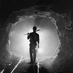
Model of a Battlefield; On the eve of the attack of June 7, 1917...1917 Creator: Unknown

![]()
Wall Art and Photo Gifts from Heritage Images
Model of a Battlefield; On the eve of the attack of June 7, 1917...1917 Creator: Unknown
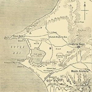
Model of a Battlefield; On the eve of the attack of June 7, 1917, on the German side of Wytschaete-Messines, Australians of the Plumer army study a huge map in relief, made in cement, to allow the men to know all the details of the ground they will cover, 1917. From "L'Album de la Guerre 1914-1919, Volume 2" [L'Illustration, Paris, 1924]
Heritage Images features heritage image collections
Media ID 36366039
© The Print Collector/Heritage Images
Australia Australian Baron Plumer Battle Of Messines Concrete Field Marshal Plumer General Plumer General Sir Herbert Plumer Hco Plumer Herbert Charles Onslow Plumer Herbert Plumer Herbert Plumer 1st Viscount Plumer Intelligence June Lalbum De La Guerre Lillustration Lord Plumer Model Month Perspective Plumer Herbert Plumer Herbert Charles Onslow Preparation Preparations Preparing Relief Sir Herbert Plumer Studying Tactical Tactics Terrain Troops Western Front Armed Services Battlefield Colonel Plumer Relief Map
FEATURES IN THESE COLLECTIONS
> Arts
> Artists
> W
> Charles White
> Arts
> Literature
> Illustration
> Europe
> France
> Paris
> Maps
> Historic
> Battles
> Related Images
> Historic
> World War I and II
> Battlefields
> Historic
> World War I and II
> Generals and leaders
> Historic
> World War I and II
> Soldiers
> Historic
> World War I and II
> World War I
> Historic
> World War I and II
EDITORS COMMENTS
On the eve of the Battle of Messines, June 7, 1917, Australian soldiers of the Plumer Army gathered around a meticulously crafted model of the battlefield on the German side of Wytschaete-Messines. The intricately detailed relief map, made of cement, allowed the men to intimately familiarize themselves with the terrain they were about to cover. This poignant image, taken from "L'Album de la Guerre 1914-1919, Volume 2" published by L'Illustration in Paris in 1924, captures a moment of quiet preparation before the intense and historic clash. The men, led by General Sir Herbert Plumer, studied the model with intense focus, their faces illuminated by the soft glow of lanterns. The map, which was not a commercial production but rather a custom creation for military intelligence purposes, offered a unique perspective on the battlefield, allowing the soldiers to visualize the complex topography and identify key strategic locations. The Battle of Messines, also known as the Capture of Wytschaete, was a significant engagement during the First World War. The Australians, under the command of Field Marshal Plumer, launched a surprise attack on the German lines, resulting in a major victory for the Allied forces. The battle marked the beginning of the end of the Third Battle of Ypres, also known as Passchendaele, and was a turning point in the war. The image serves as a poignant reminder of the meticulous planning and preparation that went into the Battle of Messines, and the dedication of the soldiers who fought in it. The relief map, a testament to the ingenuity of the military intelligence during that era, played a crucial role in the success of the operation.
MADE IN THE USA
Safe Shipping with 30 Day Money Back Guarantee
FREE PERSONALISATION*
We are proud to offer a range of customisation features including Personalised Captions, Color Filters and Picture Zoom Tools
FREE COLORIZATION SERVICE
You can choose advanced AI Colorization for this picture at no extra charge!
SECURE PAYMENTS
We happily accept a wide range of payment options so you can pay for the things you need in the way that is most convenient for you
* Options may vary by product and licensing agreement. Zoomed Pictures can be adjusted in the Cart.