Home > Animals > Mammals > Cricetidae > California Mouse
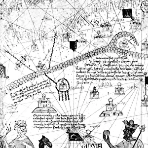
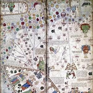
Nautical world map. (Australia is suggested but still unknown territory and, California

![]()
Wall Art and Photo Gifts from Heritage Images
Nautical world map. (Australia is suggested but still unknown territory and, California
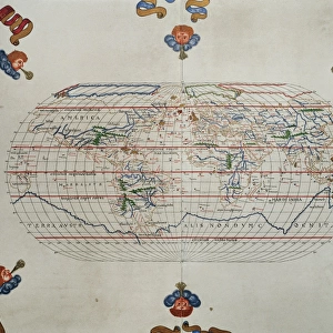
Nautical world map. (Australia is suggested but still unknown territory and, California is shown as an island), 1634. Found in the Collection of Bibliothe que Nationale de France
Heritage Images features heritage image collections
Media ID 15346577
© Cartography / Heritage-Images
Bibliotheque Nationale De France Cartography Chart Guerard Nautical Chart Portolan Portolan Chart Watercolour On Parchment 1634
FEATURES IN THESE COLLECTIONS
> Animals
> Mammals
> Cricetidae
> California Mouse
> Maps and Charts
> Related Images
> Maps and Charts
> World
> Oceania
> Australia
> Related Images
EDITORS COMMENTS
This print showcases a fascinating piece of cartographic history - the Nautical World Map from 1634. The map, found in the esteemed Collection of Bibliotheque Nationale de France, offers a unique perspective on global geography during that era. Australia is depicted as a suggested but still unknown territory, shrouded in mystery and waiting to be explored. One intriguing aspect of this map is the portrayal of California as an island, which was a common misconception at the time. This artistic interpretation adds an element of intrigue and curiosity to the overall composition. The fine art image captures the intricate details and craftsmanship involved in creating such nautical charts. Crafted by Jean Guerard, an active cartographer during the late 16th century and early 17th century, this masterpiece combines watercolor on parchment to create a visually stunning representation of our world's oceans. As we delve into this historical artifact, it serves as a reminder of how our understanding of geography has evolved over time. It sparks contemplation about past explorations and discoveries that have shaped our present knowledge. This photograph print not only preserves an important piece of history but also invites us to embark on a journey through time and space. It reminds us that there are always new frontiers awaiting exploration - both geographically and intellectually.
MADE IN THE USA
Safe Shipping with 30 Day Money Back Guarantee
FREE PERSONALISATION*
We are proud to offer a range of customisation features including Personalised Captions, Color Filters and Picture Zoom Tools
SECURE PAYMENTS
We happily accept a wide range of payment options so you can pay for the things you need in the way that is most convenient for you
* Options may vary by product and licensing agreement. Zoomed Pictures can be adjusted in the Cart.