Home > Africa > Ghana > Accra
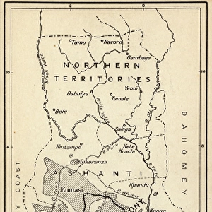
Sketch Map of the Theatre of War in Ashanti, 1900, c1900. Creator: Unknown

![]()
Wall Art and Photo Gifts from Heritage Images
Sketch Map of the Theatre of War in Ashanti, 1900, c1900. Creator: Unknown
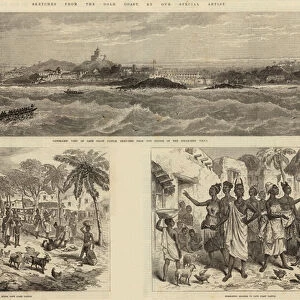
Sketch Map of the Theatre of War in Ashanti, 1900, c1900. Showing Hodgson's line of retreat, line of advance, friendly towns, rivers, roads and sites of battles. The Anglo-Ashanti wars were fought between the Ashanti Empire and the British Empire and its African allies in what became the Gold Coast, and later, Ghana. The British ultimately prevailed, resulting in the complete annexation of the Ashanti Empire by 1900. From "Cassell's History of England, Vol. IX". [Cassell and Company, Limited, London, Paris, New York & Melbourne]
Heritage Images features heritage image collections
Media ID 36339684
© The Print Collector/Heritage Images
Ashanti Campaign Cassell And Co Cassell Co Cassell Company Cassells Cassells History Of England Co Cassell Ghana Gold Coast Imperialism West Africa British Empire Cape Coast Castle Cassell And Company Ltd Fortifications
FEATURES IN THESE COLLECTIONS
> Africa
> Ghana
> Cape Coast
> Africa
> Ghana
> Ghana Heritage Sites
> Forts and Castles, Volta, Greater
> Africa
> Ghana
> Related Images
> Africa
> Related Images
> Arts
> Landscape paintings
> Waterfall and river artworks
> River artworks
> Arts
> Literature
> Europe
> France
> Canton
> Allier
EDITORS COMMENTS
This print depicts a sketch map of the 'Theatre of War in Ashanti, 1900.' The creator of this intricate work remains unknown, but it was published by Cassell and Company, Limited, in London, Paris, New York, and Melbourne around the turn of the 20th century. The map provides a detailed representation of the region that was once the Ashanti Empire in present-day Ghana, during the height of the Anglo-Ashanti Wars. The map illustrates significant features of the conflict, including Hodgson's line of retreat and advance, 'friendly' towns, rivers, roads, and sites of battles. The Anglo-Ashanti Wars were a series of conflicts between the Ashanti Empire and the British Empire and its African allies, which began in the late 19th century and continued into the early 20th century. The British ultimately prevailed, resulting in the complete annexation of the Ashanti Empire by 1900. The map showcases various landmarks, such as the coastal fortresses of Cape Coast Castle and Kumasi, the capital city of the Ashanti Empire. The fortifications, including the castle walls and battlements, are clearly visible, highlighting the strategic importance of these structures during the colonial period. The map also reveals the intricate network of roads and rivers that crisscrossed the region, providing vital transportation routes for both the British and the Ashanti forces. This print offers a unique glimpse into the history of the Gold Coast, providing valuable insights into the geography, politics, and military strategies of the Anglo-Ashanti Wars. It is a testament to the rich cultural and historical heritage of West Africa and the complexities of the colonial era.
MADE IN THE USA
Safe Shipping with 30 Day Money Back Guarantee
FREE PERSONALISATION*
We are proud to offer a range of customisation features including Personalised Captions, Color Filters and Picture Zoom Tools
SECURE PAYMENTS
We happily accept a wide range of payment options so you can pay for the things you need in the way that is most convenient for you
* Options may vary by product and licensing agreement. Zoomed Pictures can be adjusted in the Cart.