Rights Managed > Historic England > Landscapes > Aerial Views
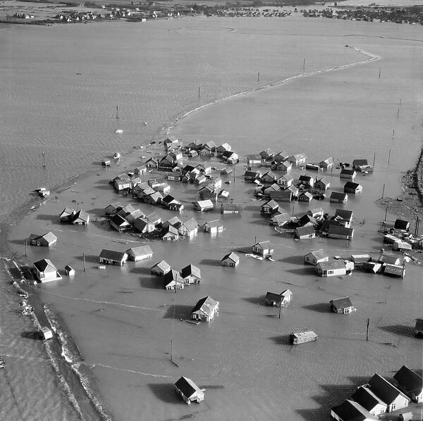
Coastal flooding 1953 EAW048271
Filename: afl03_aerofilms_a48271.jpg
Size: 4320 x 4304 (7.4MB)
Date: 17th July 2009
Source: Historic England
Credit: Historic England Archive Aerofilms C
Source: English Heritage Images
© Historic England
![]()

Wall Art and Photo Gifts from Historic England
Coastal flooding 1953 EAW048271
JAYWICK SANDS, Essex. Aerial photograph taken on 2nd February 1953 showing flooded housing following the great East Coast storm surge which hit the coast overnight on 31st January. At Jaywick, near Clacton, the sea rose a metre in 15 minutes and 35 people drowned. In the photo are the submerged remains of Triumph Avenue, Crossley Avenue, Singer Avenue, Rover Avenue, Standard Avenue and Daimler Avenue. A hexagonal pillbox which is still at the end of Rover Avenue (at OS NGR TM140130) can be made out on the left hand side of the image. The road in the distance is Meadow Way. Aerofilms Collection (see Links)
Historic England is the public body that champions and protects England's historic places
Media ID 1630077
© Historic England
FEATURES IN THESE COLLECTIONS
> More features
> Climate and weather
> Flooding
> Flight
> England from the Air
> East of England from the air
> Historic Images
> Aerofilms Collection (1919-2006)
> Historic Images
> Historic Images 1900s - 1910s
EDITORS COMMENTS
In this evocative aerial photograph taken on February 2nd, 1953, the devastating impact of the Great East Coast storm surge is captured as never before. The scene is Jaywick Sands, Essex, a tranquil coastal community that was mercilessly hit by the relentless sea overnight on January 31st. The once familiar landscape of Triumph Avenue, Crossley Avenue, Singer Avenue, Rover Avenue, and Standard Avenue are now submerged under the churning waters of the North Sea. The photograph reveals a haunting tableau of desolation. Houses, their roofs torn off, lie abandoned and forlorn, their foundations swallowed by the encroaching tide. Thirty-five innocent lives were lost in this catastrophic event, with the sea rising a metre in a mere fifteen minutes. On the left-hand side of the image, a hexagonal pillbox, a relic of a bygone era, can be discerned at the end of Rover Avenue (OS NGR TM140130). This fortification, a testament to the past, stands defiant against the onslaught of the sea, a poignant reminder of a time when the threat of invasion was a very real concern. In the distance, Meadow Way, the road leading to the heart of the community, is barely visible, its continuity broken by the relentless power of the sea. This photograph, a poignant snapshot of history, serves as a stark reminder of the destructive forces of nature and the resilience of the human spirit in the face of adversity. This photograph is part of the extensive Aerofilms Collection, held by Historic England, and provides a unique perspective on the past. It is a testament to the power of aerial photography to capture the essence of history and preserve it for future generations.
MADE IN THE USA
Safe Shipping with 30 Day Money Back Guarantee
FREE PERSONALISATION*
We are proud to offer a range of customisation features including Personalised Captions, Color Filters and Picture Zoom Tools
FREE COLORIZATION SERVICE
You can choose advanced AI Colorization for this picture at no extra charge!
SECURE PAYMENTS
We happily accept a wide range of payment options so you can pay for the things you need in the way that is most convenient for you
* Options may vary by product and licensing agreement. Zoomed Pictures can be adjusted in the Cart.

