Home > Europe > United Kingdom > England > Birmingham > Area > Soho
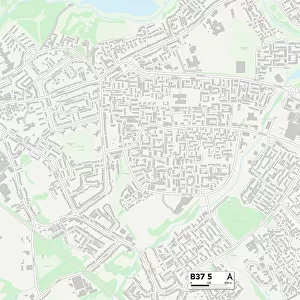
Birmingham B21 9 Map

![]()
Wall Art and Photo Gifts from Map Marketing
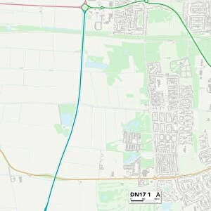
Birmingham B21 9 Map
Postcode Sector Map of Birmingham B21 9
Media ID 19965347
Albert Road Alfred Road Arthur Road Babington Road Baker Street Barn Lane Belgrave Terrace Birmingham Branksome Avenue Brunswick Gardens Brunswick Road Chantry Road Dawson Road Douglas Road Elmhurst Road Grove Lane Herbert Road Highbury Avenue Ivy Road Lansdowne Road Laurel Gardens Laurel Road Linwood Road Maple Close Mervyn Road Montague Road Mostyn Road Mount Pleasant Avenue Murdock Road Oakland Road Orchard Close Osborne Road Park Terrace Rookery Road St Michaels Road Stafford Road Thornhill Road Trafalgar Road Whitehall Road Woodstock Road York Road
FEATURES IN THESE COLLECTIONS
> Arts
> Artists
> D
> Alfred
> Related Images
> Europe
> United Kingdom
> England
> Birmingham
> Area
> Soho
> Europe
> United Kingdom
> England
> London
> Sights
> Golders Hill Park
> Europe
> United Kingdom
> Scotland
> Dumfries and Galloway
> Thornhill
> Map Marketing
> Postcode Sector Maps
> B - Birmingham
> Maps and Charts
> Related Images
MADE IN THE USA
Safe Shipping with 30 Day Money Back Guarantee
FREE PERSONALISATION*
We are proud to offer a range of customisation features including Personalised Captions, Color Filters and Picture Zoom Tools
SECURE PAYMENTS
We happily accept a wide range of payment options so you can pay for the things you need in the way that is most convenient for you
* Options may vary by product and licensing agreement. Zoomed Pictures can be adjusted in the Cart.