Home > Europe > United Kingdom > England > London > Boroughs > Bromley
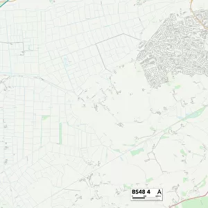
Bath and North East Somerset BS39 4 Map

![]()
Wall Art and Photo Gifts from Map Marketing
Bath and North East Somerset BS39 4 Map
Postcode Sector Map of Bath and North East Somerset BS39 4
Media ID 19966864
Barn Lane Bath And North East Somerset Birchwood Lane Bristol Road Bromley Road Church Lane Church Road Church Street Court Hill High Street Highfields Hillcrest Mill Lane New Road Northwick Road Norton Lane Old Road Parsonage Lane Sandy Lane School Lane Slate Lane Stanton Lane Station Approach The Drive The Orchard Vicarage Lane Wick Lane Blackrock
FEATURES IN THESE COLLECTIONS
> Europe
> United Kingdom
> England
> Bristol
> Bristol
> Europe
> United Kingdom
> England
> London
> Boroughs
> Bromley
> Europe
> United Kingdom
> England
> Somerset
> Bath
> Europe
> United Kingdom
> England
> Somerset
> Related Images
> Europe
> United Kingdom
> England
> Somerset
> Street
> Europe
> United Kingdom
> Scotland
> Highlands
> Wick
> Map Marketing
> Postcode Sector Maps
> BS - Bristol
> Maps and Charts
> Related Images
MADE IN THE USA
Safe Shipping with 30 Day Money Back Guarantee
FREE PERSONALISATION*
We are proud to offer a range of customisation features including Personalised Captions, Color Filters and Picture Zoom Tools
SECURE PAYMENTS
We happily accept a wide range of payment options so you can pay for the things you need in the way that is most convenient for you
* Options may vary by product and licensing agreement. Zoomed Pictures can be adjusted in the Cart.