Home > Maps and Charts > Related Images
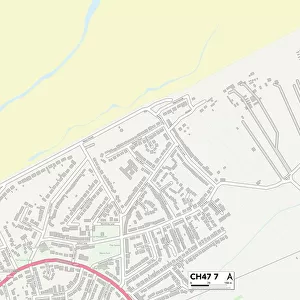
Wirral CH48 2 Map

![]()
Wall Art and Photo Gifts from Map Marketing
Wirral CH48 2 Map
Postcode Sector Map of Wirral CH48 2
Media ID 19968248
Ashmore Close Beatty Close Caldy Road Carisbrooke Close Ch48 Croft Drive Cunningham Close Davenport Close Devonshire Road Jellicoe Close Kings Drive Kirby Close Mount Road Norfolk Drive Shore Lane Shore Road Surrey Drive The Green Warwick Drive Wirral Westward Ho
FEATURES IN THESE COLLECTIONS
> Europe
> United Kingdom
> England
> Norfolk
> Related Images
> Europe
> United Kingdom
> England
> Surrey
> Related Images
> Map Marketing
> Postcode Sector Maps
> CH - Chester
> Maps and Charts
> Related Images
MADE IN THE USA
Safe Shipping with 30 Day Money Back Guarantee
FREE PERSONALISATION*
We are proud to offer a range of customisation features including Personalised Captions, Color Filters and Picture Zoom Tools
SECURE PAYMENTS
We happily accept a wide range of payment options so you can pay for the things you need in the way that is most convenient for you
* Options may vary by product and licensing agreement. Zoomed Pictures can be adjusted in the Cart.