Home > Europe > United Kingdom > England > London > Boroughs > Havering
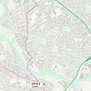
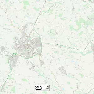
Brentwood CM13 1 Map

![]()
Wall Art and Photo Gifts from Map Marketing
Brentwood CM13 1 Map
Postcode Sector Map of Brentwood CM13 1
Media ID 19967766
Alpha Road Beaumont Gardens Birkbeck Road Boundary Drive Brentwood Burnthouse Lane Cedar Close Cedar Road Church Lane Church Road Cotswold Gardens Delta Road Edwards Close Fairview Avenue Farm Close Goodwood Avenue Graham Close Harrison Close Hatfield Close Haywards Close Hunters Chase Hutton Drive Lambourne Drive Laurel Close Lodge Close Lonsdale Avenue Marsh Lane Mount Pleasant Avenue Nethergate Newlands Close North Drive Oakbank Oakwood Avenue Old Church Lane Old Church Road Pine Crescent Poplar Drive Prospect Way Queenswood Avenue Rayleigh Close Rayleigh Road Shaw Crescent Shelley Road Springfield Avenue The Retreat The Spinney Waltham Close Walton Gardens Whittington Road Willow Close Woodland Avenue Woodland Close Woodside Close Yew Tree Close Normanhurst
FEATURES IN THESE COLLECTIONS
> Europe
> United Kingdom
> England
> London
> Boroughs
> Havering
> Map Marketing
> Postcode Sector Maps
> CM - Chelmsford
> Maps and Charts
> Related Images
MADE IN THE USA
Safe Shipping with 30 Day Money Back Guarantee
FREE PERSONALISATION*
We are proud to offer a range of customisation features including Personalised Captions, Color Filters and Picture Zoom Tools
SECURE PAYMENTS
We happily accept a wide range of payment options so you can pay for the things you need in the way that is most convenient for you
* Options may vary by product and licensing agreement. Zoomed Pictures can be adjusted in the Cart.