Home > Europe > United Kingdom > Scotland > Aberdeenshire > Stonehaven
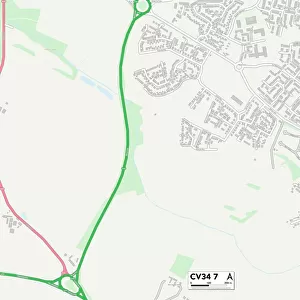
Coventry CV3 6 Map

![]()
Wall Art and Photo Gifts from Map Marketing
Coventry CV3 6 Map
Postcode Sector Map of Coventry CV3 6
Media ID 19968067
A429 Alfriston Road Brentwood Avenue Canford Close Cotswold Drive Coventry Delaware Road Easedale Close Frobisher Road Grange Avenue Grasmere Avenue Green Lane Gregory Avenue Hadleigh Road Kenilworth Road Leamington Road Leigh Avenue Magnolia Close Mill Hill Norwich Drive Oak Tree Avenue Orchard Crescent Peveril Drive Regency Drive Roman Way St Martins Road Stoney Road Thirsk Road Townsend Road Underhill Close Wade Avenue Warwick Road
FEATURES IN THESE COLLECTIONS
> Arts
> Artists
> R
> Roman Roman
> Europe
> United Kingdom
> Scotland
> Aberdeenshire
> Stonehaven
> Europe
> United Kingdom
> Scotland
> Dumfries and Galloway
> Gretna
> Europe
> United Kingdom
> Scotland
> Scottish Borders
> Jedburgh
> Map Marketing
> Postcode Sector Maps
> CV - Coventry
> Maps and Charts
> Related Images
> North America
> Saint Martin
> Maps
MADE IN THE USA
Safe Shipping with 30 Day Money Back Guarantee
FREE PERSONALISATION*
We are proud to offer a range of customisation features including Personalised Captions, Color Filters and Picture Zoom Tools
SECURE PAYMENTS
We happily accept a wide range of payment options so you can pay for the things you need in the way that is most convenient for you
* Options may vary by product and licensing agreement. Zoomed Pictures can be adjusted in the Cart.