Home > Europe > United Kingdom > Wales > South Glamorgan > Barry
Leicester LE9 2 Map

![]()
Wall Art and Photo Gifts from Map Marketing
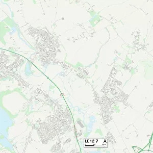
Leicester LE9 2 Map
Postcode Sector Map of Leicester LE9 2
Media ID 19973452
Abbot Close Barns Close Barons Close Barry Close Bluebell Close Castle Road Cherry Tree Avenue Church Road Court Close Ellis Drive Forest Drive Forest Rise Fox Lane Hastings Road Hawthorn Close Hedgerow Lane Highland Avenue Hinckley Road Holt Drive Kirby Lane Ladysmith Road Leicester Lime Grove Links Road Main Street Martin Avenue Maytree Close Portland Road Pretoria Road Primrose Way Princess Drive Roman Avenue Rosedene Close Shepherd Close Stamford Road Station Close Station Drive Station Road The Croft The Fairway The Keep Towers Close Vicarage Close Walton Close Woodlands Lane
FEATURES IN THESE COLLECTIONS
> Architecture
> Towers
> Castles
> Architecture
> Towers
> Churches
> Arts
> Artists
> R
> Roman Roman
> Arts
> Landscape paintings
> Forest and woodland scenes
> Forest artwork
> Europe
> United Kingdom
> Wales
> South Glamorgan
> Barry
> Map Marketing
> Postcode Sector Maps
> LE - Leicester
> Maps and Charts
> Related Images
MADE IN THE USA
Safe Shipping with 30 Day Money Back Guarantee
FREE PERSONALISATION*
We are proud to offer a range of customisation features including Personalised Captions, Color Filters and Picture Zoom Tools
SECURE PAYMENTS
We happily accept a wide range of payment options so you can pay for the things you need in the way that is most convenient for you
* Options may vary by product and licensing agreement. Zoomed Pictures can be adjusted in the Cart.