Home > Europe > United Kingdom > England > London > Boroughs > Haringey
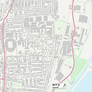
Haringey N17 8 Map

![]()
Wall Art and Photo Gifts from Map Marketing
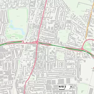
Haringey N17 8 Map
Postcode Sector Map of Haringey N17 8
Media ID 19976182
Acacia Avenue Birkbeck Road Brereton Road Cedar Road Cemetery Road Church Road College Road Durban Road Gretton Road Haringey Headcorn Road James Place King Street Kings Road Laburnum Avenue Love Lane New Road Nursery Court Nursery Street Oak Avenue Orchard Place Pembury Road Penshurst Road Pretoria Road Princes Street Queen Street Ruskin Road Selby Road Tenterden Road Trafalgar Avenue White Hart Lane Whitehall Street William Street
FEATURES IN THESE COLLECTIONS
> Arts
> Artists
> H
> William Hart
> Arts
> Artists
> J
> William James
> Arts
> Artists
> W
> William White
> Europe
> United Kingdom
> England
> London
> Boroughs
> Haringey
> Map Marketing
> Postcode Sector Maps
> N - London N
> Maps and Charts
> Related Images
MADE IN THE USA
Safe Shipping with 30 Day Money Back Guarantee
FREE PERSONALISATION*
We are proud to offer a range of customisation features including Personalised Captions, Color Filters and Picture Zoom Tools
SECURE PAYMENTS
We happily accept a wide range of payment options so you can pay for the things you need in the way that is most convenient for you
* Options may vary by product and licensing agreement. Zoomed Pictures can be adjusted in the Cart.