Home > Animals > Mammals > Muridae > Ling
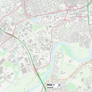
South Kesteven NG32 1 Map

![]()
Wall Art and Photo Gifts from Map Marketing
South Kesteven NG32 1 Map
Postcode Sector Map of South Kesteven NG32 1
Media ID 19975986
Back Lane Belvoir Road Butt Lane Chapel Hill Chapel Lane Chapel Street Charnwood Close Church Hill Church Lane Church Street Cliff Road Craven Close Denton Eaton Elm Lane Gregory Close Heath Lane High Road High Street Highfield Crescent Highfields Hillside Road Leys Close Longmoor Lane Low Road Main Street Manor Drive Manor Road Middle Street Mill Lane Mill Row Nether Lane Nursery Lane Old Orchard Park Lane Parklands Drive Pasture Lane Pond Street Rectory Close Rectory Lane School Lane South Kesteven The Drift The Nook The Rock The Square Top Road Vicarage Lane Village Street Walkers Way Waltham Road Walton Way West End Belvoir Harston
FEATURES IN THESE COLLECTIONS
> Animals
> Mammals
> Muridae
> Heath Mouse
> Animals
> Mammals
> Muridae
> Ling
> Map Marketing
> Postcode Sector Maps
> NG - Nottingham
> Maps and Charts
> Related Images
MADE IN THE USA
Safe Shipping with 30 Day Money Back Guarantee
FREE PERSONALISATION*
We are proud to offer a range of customisation features including Personalised Captions, Color Filters and Picture Zoom Tools
SECURE PAYMENTS
We happily accept a wide range of payment options so you can pay for the things you need in the way that is most convenient for you
* Options may vary by product and licensing agreement. Zoomed Pictures can be adjusted in the Cart.