Home > Europe > United Kingdom > England > London > Towns > Woodside Park
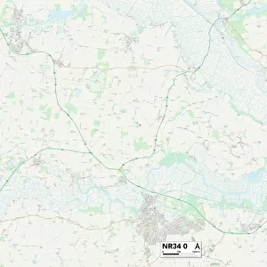
Suffolk NR34 8 Map

![]()
Wall Art and Photo Gifts from Map Marketing
Suffolk NR34 8 Map
Postcode Sector Map of Suffolk NR34 8
Media ID 19976868
Blacksmith Close Brampton Bungay Road Castle Road Chapel Road Church Close Church Lane Church Road Church Street Clarkes Lane Cromwell Road Elms Lane Green Lane Halesworth Road Hall Road High Street Hill Road Kiln Road Kings Lane Locks Lane London Road Love Lane Low Road Manor Farm Road Mill Lane Millfields Norfolk Road Old School Close Primrose Lane Sandy Lane School Road School View Southwell Road Southwold Road Station Road Suffolk The Hill The Orchard The Street Top Road Wash Lane Weston Woodfield Close Woodside Hog Lane Sotherton Spring Park The City
FEATURES IN THESE COLLECTIONS
> Arts
> Artists
> R
> Andrew Russell
> Europe
> United Kingdom
> England
> London
> Sights
> Green Park
> Europe
> United Kingdom
> England
> London
> Towns
> Clay Hill
> Europe
> United Kingdom
> England
> London
> Towns
> Elm Park
> Europe
> United Kingdom
> England
> London
> Towns
> Mill Hill
> Europe
> United Kingdom
> England
> London
> Towns
> Primrose Hill
> Europe
> United Kingdom
> England
> London
> Towns
> Woodside Park
> Europe
> United Kingdom
> England
> London
> Towns
> Woodside
> Europe
> United Kingdom
> England
> Norfolk
> Brampton
> Europe
> United Kingdom
> England
> Norfolk
> Bungay
> Map Marketing
> Postcode Sector Maps
> NR - Norwich
MADE IN THE USA
Safe Shipping with 30 Day Money Back Guarantee
FREE PERSONALISATION*
We are proud to offer a range of customisation features including Personalised Captions, Color Filters and Picture Zoom Tools
SECURE PAYMENTS
We happily accept a wide range of payment options so you can pay for the things you need in the way that is most convenient for you
* Options may vary by product and licensing agreement. Zoomed Pictures can be adjusted in the Cart.