Home > Europe > United Kingdom > Wales > Ceredigion > Cardigan
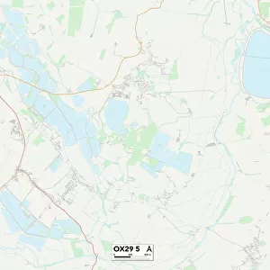
Oxford OX2 6 Map

![]()
Wall Art and Photo Gifts from Map Marketing
Oxford OX2 6 Map
Postcode Sector Map of Oxford OX2 6
Media ID 19977152
Adelaide Street Albert Street Brindley Close Canal Street Canterbury Road Cardigan Street Church Walk Combe Road Crick Road Dawson Place Farndon Road Fyfield Road Hart Street Hayfield Road King Street Kingston Road Linton Road Longworth Road Mount Street Navigation Way Nelson Street Oxford Plantation Road Rawlinson Road School Court Southmoor Road St Bernards Road St Margarets Road Stable Close Victor Street Walton Street Wellington Street Winchester Road Jericho Park Town
FEATURES IN THESE COLLECTIONS
> Arts
> Artists
> H
> William Hart
> Arts
> Artists
> L
> William Linton
> Arts
> Artists
> P
> Linton Park
> Europe
> United Kingdom
> Wales
> Ceredigion
> Cardigan
> Map Marketing
> Postcode Sector Maps
> OX - Oxford
> Maps and Charts
> Related Images
> Popular Themes
> King Arthur
MADE IN THE USA
Safe Shipping with 30 Day Money Back Guarantee
FREE PERSONALISATION*
We are proud to offer a range of customisation features including Personalised Captions, Color Filters and Picture Zoom Tools
SECURE PAYMENTS
We happily accept a wide range of payment options so you can pay for the things you need in the way that is most convenient for you
* Options may vary by product and licensing agreement. Zoomed Pictures can be adjusted in the Cart.