Home > Animals > Birds > Passerines > Crows And Jays > Rook
South Oxfordshire OX9 2 Map

![]()
Wall Art and Photo Gifts from Map Marketing
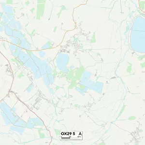
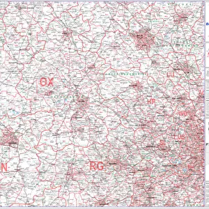
South Oxfordshire OX9 2 Map
Postcode Sector Map of South Oxfordshire OX9 2
Media ID 19977229
Beech Road Brook Lane Brookside Close Causeway Close Cedar Crescent Chestnut Avenue College Close Elms Road Fernhill Close Hawthorn Avenue Hazel Avenue Highfield Close Jubilee Gardens London Road Manor Farm Close Maple Road Mitchell Close Moreton Moreton Lane Moreton Road Nelson Street North Close Old London Road Oxford Road Roman Way Sandy Lane South Oxfordshire Southern Road Station Yard Sycamore Drive Thame Road The Homestead Town Farm Close Weston Lane Windmill Road Albury
FEATURES IN THESE COLLECTIONS
> Animals
> Birds
> Passerines
> Crows And Jays
> Rook
> Animals
> Fishes
> Related Images
> Arts
> Artists
> B
> John Brooks
> Arts
> Artists
> H
> John Hillers
> Arts
> Artists
> H
> John Hills
> Arts
> Artists
> M
> John Milton
> Arts
> Artists
> R
> Roman Roman
> Europe
> United Kingdom
> England
> Oxfordshire
> Dorchester
> Europe
> United Kingdom
> England
> Oxfordshire
> Milton Hill
> Europe
> United Kingdom
> England
> Oxfordshire
> Milton
> Map Marketing
> Postcode Sector Maps
> OX - Oxford
MADE IN THE USA
Safe Shipping with 30 Day Money Back Guarantee
FREE PERSONALISATION*
We are proud to offer a range of customisation features including Personalised Captions, Color Filters and Picture Zoom Tools
SECURE PAYMENTS
We happily accept a wide range of payment options so you can pay for the things you need in the way that is most convenient for you
* Options may vary by product and licensing agreement. Zoomed Pictures can be adjusted in the Cart.