Home > Animals > Birds > Passerines > Crows And Jays > Related Images
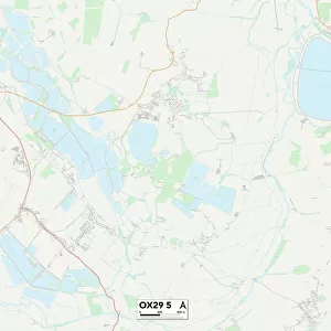
West Oxfordshire OX20 1 Map

![]()
Wall Art and Photo Gifts from Map Marketing
West Oxfordshire OX20 1 Map
Postcode Sector Map of West Oxfordshire OX20 1
Media ID 19977341
Ashford Close Banbury Road Blackberry Way Boundary Close Brook Hill Browns Lane Castle Road Chapel Hill Church Street Churchill Close Crow Lane Glovers Close Green Lane Grove Road Heath Lane High Street Hill Rise Home Farm Close Horseshoe Lane Lamb Lane Lambs Lane Lincoln Grove Main Road Manor Court Manor Road Market Place Market Street Marlborough Crescent Marriott Close Meadow Walk Mill Lane New Road Oxford Road Oxford Street Park Close Park Lane Park Road Park Side Park Street Recreation Road Rectory Lane Shipton Road Spencer Close St Andrews Square The Causeway The Covert The Green The Homestead The Quadrangle The Row Top Lane Union Street Walnut Close West End West Oxfordshire Woodstock Wootton Bladon Hedge End
FEATURES IN THESE COLLECTIONS
> Animals
> Birds
> Passerines
> Crows And Jays
> Related Images
> Animals
> Mammals
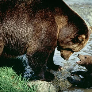
> Brown Bear
> Animals
> Mammals
> Muridae
> Heath Mouse
> Animals
> Mammals
> Ursidae
> Brown bear
> Animals
> Wild
> Bears
> Brown Bear
> Europe
> United Kingdom
> England
> Oxfordshire
> Banbury
> Europe
> United Kingdom
> England
> Oxfordshire
> Bladon
> Europe
> United Kingdom
> England
> Oxfordshire
> Churchill
> Europe
> United Kingdom
> England
> Oxfordshire
> Grove
> Europe
> United Kingdom
> England
> Oxfordshire
> Kiddington
> Map Marketing
> Postcode Sector Maps
> OX - Oxford
MADE IN THE USA
Safe Shipping with 30 Day Money Back Guarantee
FREE PERSONALISATION*
We are proud to offer a range of customisation features including Personalised Captions, Color Filters and Picture Zoom Tools
SECURE PAYMENTS
We happily accept a wide range of payment options so you can pay for the things you need in the way that is most convenient for you
* Options may vary by product and licensing agreement. Zoomed Pictures can be adjusted in the Cart.