Home > Arts > Artists > B > John Burr
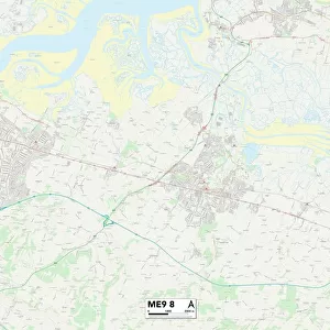
Swale ME10 4 Map

![]()
Wall Art and Photo Gifts from Map Marketing
Swale ME10 4 Map
Postcode Sector Map of Swale ME10 4
Media ID 19975105
Albany Road Arundel Avenue Bell Road Blenheim Road Bluebell Drive Cambridge Road Canterbury Road Capel Road Cedar Close Central Avenue Clarendon Close Cromer Road Crossways East Street Fairview Road Fallowfield Glebe Lane Greenways Hanover Close Harrier Drive Harvey Drive Heather Close High Street Kestrel Close Kiln Close Longridge Merlin Close Middle Way Millfield Muddy Lane Northwood Drive Orchard Place Penn Close Peregrine Drive Primrose Avenue Prince Charles Avenue Rectory Road School Road South Avenue St Johns Avenue Stanhope Avenue Swale Temple Gardens The Fairway The Fieldings The Finches The Meadows The Mews The Roundel Warren Close Whitehall Road Woodlands Road Woodstock Road Sittingbourne
FEATURES IN THESE COLLECTIONS
> Animals
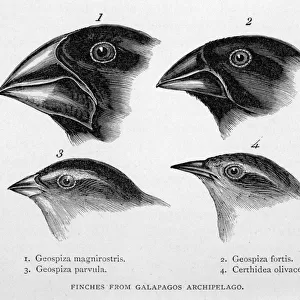
> Birds
> Passerines
> Finches
> Related Images
> Arts
> Artists
> B
> Charles Bell
> Arts
> Artists
> B
> John Burr
> Arts
> Artists
> F
> John Field
> Arts
> Artists
> G
> John Glover
> Arts
> Artists
> H
> John Hillers
> Arts
> Artists
> H
> John Hills
> Arts
> Artists
> R
> Roman Roman
> Map Marketing
> Postcode Sector Maps
> ME - Rochester
> Maps and Charts
> Related Images
MADE IN THE USA
Safe Shipping with 30 Day Money Back Guarantee
FREE PERSONALISATION*
We are proud to offer a range of customisation features including Personalised Captions, Color Filters and Picture Zoom Tools
SECURE PAYMENTS
We happily accept a wide range of payment options so you can pay for the things you need in the way that is most convenient for you
* Options may vary by product and licensing agreement. Zoomed Pictures can be adjusted in the Cart.