Home > Europe > United Kingdom > England > London > Boroughs > Greenwich
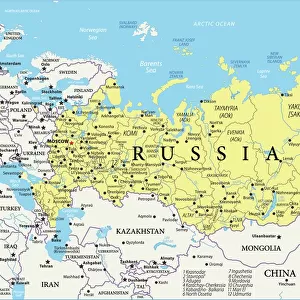
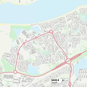
Greenwich SE18 5 Map

![]()
Wall Art and Photo Gifts from Map Marketing
Greenwich SE18 5 Map
Postcode Sector Map of Greenwich SE18 5
Media ID 19981768
Church Hill Dairy Lane Frances Street Godfrey Road Greenwich Lamport Close Marine Drive Mulgrave Road Rectory Place Richard Close Samuel Close Samuel Street Spindle Close St Mary Street Swan Road Westfield Street Whitby Road Willow Lane Woodhill Woodrow Se18 Tivoli Gardens Woolwich Dockyard
FEATURES IN THESE COLLECTIONS
> Animals
> Insects
> Spiders
> European Garden
> Arts
> Artists
> G
> Charles Green
> Arts
> Artists
> L
> Samuel Lane
> Europe
> Italy
> Lazio
> Tivoli
> Europe
> United Kingdom
> England
> London
> Boroughs
> Greenwich
> Europe
> United Kingdom
> Scotland
> Aberdeenshire
> Maud
> Europe
> United Kingdom
> Scotland
> Scottish Borders
> Greenlaw
> Map Marketing
> Postcode Sector Maps
> SE - London SE
> Maps and Charts
> Related Images
MADE IN THE USA
Safe Shipping with 30 Day Money Back Guarantee
FREE PERSONALISATION*
We are proud to offer a range of customisation features including Personalised Captions, Color Filters and Picture Zoom Tools
SECURE PAYMENTS
We happily accept a wide range of payment options so you can pay for the things you need in the way that is most convenient for you
* Options may vary by product and licensing agreement. Zoomed Pictures can be adjusted in the Cart.