Home > Europe > United Kingdom > England > Devon > Eastleigh
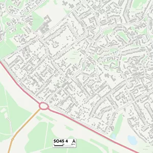
Eastleigh SO53 3 Map

![]()
Wall Art and Photo Gifts from Map Marketing
Eastleigh SO53 3 Map
Postcode Sector Map of Eastleigh SO53 3
Media ID 19978706
Belmont Road Bournemouth Road Brecon Close Brickfield Lane Brook Close Cambridge Drive Chestnut Avenue Chestnut Close Conway Close Cornwall Road Devon Close Devon Drive Dorset Road Eastleigh Falkland Road Ford Avenue Holland Close Howard Close Hurst Close Keble Close Keble Road Kent Road Leigh Road Lulworth Close Meadow Grove Montgomery Way Netley Close Nursery Gardens Pennine Way Rowlands Close Shaftesbury Avenue Skipton Road Suffolk Close Suffolk Drive Surrey Road Sussex Road Templars Way The Croft The Crossways The Oaklands Tollgate Westfield Crescent Westfield Road Wiltshire Road Red Lodge
FEATURES IN THESE COLLECTIONS
> Europe
> United Kingdom
> England
> Cornwall
> Lane-end
> Europe
> United Kingdom
> England
> Cornwall
> Related Images
> Europe
> United Kingdom
> England
> Cornwall
> Row
> Europe
> United Kingdom
> England
> Devon
> Eastleigh
> Europe
> United Kingdom
> England
> Devon
> Ford
> Europe
> United Kingdom
> England
> Devon
> Related Images
> Europe
> United Kingdom
> England
> Dorset
> Bournemouth
> Europe
> United Kingdom
> England
> Dorset
> Grove
> Europe
> United Kingdom
> England
> Dorset
> Lane End
> Europe
> United Kingdom
> England
> Dorset
> Leigh
> Map Marketing
> Postcode Sector Maps
> SO - Southampton
MADE IN THE USA
Safe Shipping with 30 Day Money Back Guarantee
FREE PERSONALISATION*
We are proud to offer a range of customisation features including Personalised Captions, Color Filters and Picture Zoom Tools
SECURE PAYMENTS
We happily accept a wide range of payment options so you can pay for the things you need in the way that is most convenient for you
* Options may vary by product and licensing agreement. Zoomed Pictures can be adjusted in the Cart.