Home > Arts > Artists > H > Jodocus Hondius
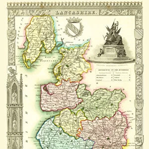
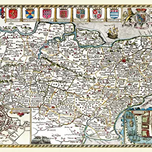
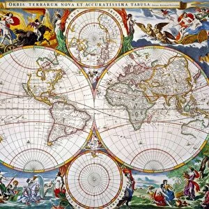
Old County Map of Lancashire 1648 by Johan Blaeu from the Atlas Novus

![]()
Wall Art and Photo Gifts from MapSeeker
Old County Map of Lancashire 1648 by Johan Blaeu from the Atlas Novus
This detailed and most attractive reproduction map of Lancashire has been carefully art worked from a scan of an antique original. The famous firm of Dutch cartographers and publishers was established in the late 16th century by Willem Janszoon Blaeu in Amsterdam. Blaeu was a maker of globes and scientific instruments and purchased some of his early map plates from Jodocus Hondius. From this small beginning was to emerge one of the largest and most prolific map publishing houses of the seventeenth century
Welcome to the Mapseeker Image library and enter an historic gateway to one of the largest on-line collections of Historic Maps, Nostalgic Views, Vista's and Panorama's from a World gone by.
Media ID 20347850
Blaeu Blaeu Family Blaue Map County Map County Map Of England English County Map Historic Map Johan Blaeu Johan Blaeu Map Old Blaue Map Old County Map Old English County Map Lancashire
FEATURES IN THESE COLLECTIONS
> Arts
> Artists
> B
> Willem Blaeu
> Arts
> Artists
> H
> Jodocus Hondius
> Arts
> Photorealistic artworks
> Detailed art pieces
> Masterful detailing in art
> Europe
> United Kingdom
> England
> Lancashire
> Related Images
> Europe
> United Kingdom
> England
> Maps
> Maps and Charts
> Early Maps
> Maps and Charts
> Related Images
> Maps and Charts
> Willem Janszoon Blaeu
> MapSeeker
> Maps from the British Isles
> England and Counties PORTFOLIO
EDITORS COMMENTS
This stunning print features an Old County Map of Lancashire from 1648, created by the renowned Dutch cartographer Johan Blaeu. Carefully reproduced from an antique original, this detailed and visually captivating map showcases the rich history of Lancashire. The Blaeu family's legacy in cartography began with Willem Janszoon Blaeu, who established their prestigious firm in Amsterdam during the late 16th century. Initially known for crafting globes and scientific instruments, they soon expanded into map publishing. Acquiring some of their early map plates from Jodocus Hondius, the Blaeu family would go on to become one of the largest and most prolific map publishers of the seventeenth century. This particular reproduction highlights Lancashire's significance within England's historical landscape. Its intricate details offer a glimpse into centuries past, capturing both geographical features and important landmarks that shaped the county's identity. Whether you are a lover of old English county maps or a historian seeking to explore Lancashire's heritage, this authentic piece will undoubtedly captivate your imagination. Let it transport you back in time as you delve into its fascinating intricacies – a true testament to Johan Blaeu's skillful craftsmanship and dedication to preserving our collective history.
MADE IN THE USA
Safe Shipping with 30 Day Money Back Guarantee
FREE PERSONALISATION*
We are proud to offer a range of customisation features including Personalised Captions, Color Filters and Picture Zoom Tools
SECURE PAYMENTS
We happily accept a wide range of payment options so you can pay for the things you need in the way that is most convenient for you
* Options may vary by product and licensing agreement. Zoomed Pictures can be adjusted in the Cart.